
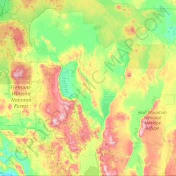
Lake County topographic map
Interactive map
Click on the map to display elevation.
About this map
Name: Lake County topographic map, elevation, terrain.
Location: Lake County, Oregon, United States (41.99301 -121.35122 43.61761 -119.35940)
Average elevation: 5,052 ft
Minimum elevation: 4,045 ft
Maximum elevation: 8,301 ft
Lake County ranges in elevation from 4,130 to 8,446 feet (1,259 to 2,574 m). The highest point in Lake County is Crane Mountain. The mountain is located 6 miles (9.7 km) north of the California border. Lake County has six other peaks with elevations above 8,000 feet (2,400 m), all located in the southern half of the county. Hager Mountain is the highest peak in the northern part of the county.
Other topographic maps
Click on a map to view its topography, its elevation and its terrain.
Portland
United States > Oregon > Multnomah County
Portland, Multnomah County, Oregon, United States
Average elevation: 253 ft
Eugene
United States > Oregon > Lane County
Eugene, Lane County, Oregon, United States
Average elevation: 535 ft
Salem
United States > Oregon > Marion County
Salem, Marion County, Oregon, United States
Average elevation: 315 ft
Bend
United States > Oregon > Deschutes County
Bend, Deschutes County, Oregon, United States
Average elevation: 3,678 ft
Klamath Falls
United States > Oregon > Klamath County
Klamath Falls, Klamath County, Oregon, 97601, United States
Average elevation: 4,304 ft
Corvallis
United States > Oregon > Benton County
Corvallis, Benton County, Oregon, United States
Average elevation: 266 ft
Redmond
United States > Oregon > Deschutes County
Redmond, Deschutes County, Oregon, 91156, United States
Average elevation: 3,028 ft
La Pine
United States > Oregon > Deschutes County
La Pine, Deschutes County, Oregon, 97739, United States
Average elevation: 4,232 ft
McMinnville
United States > Oregon > Yamhill County
McMinnville, Yamhill County, Oregon, 97128, United States
Average elevation: 164 ft
Newport
United States > Oregon > Lincoln County
Newport, Lincoln County, Oregon, United States
Average elevation: 108 ft
Ashland
United States > Oregon > Jackson County
Ashland, Jackson County, Oregon, United States
Average elevation: 2,539 ft
Lincoln City
United States > Oregon > Lincoln County
Lincoln City, Lincoln County, Oregon, United States
Average elevation: 154 ft
Grants Pass
United States > Oregon > Josephine County
Grants Pass, Josephine County, Oregon, United States
Average elevation: 1,227 ft
Astoria
United States > Oregon > Clatsop County
Astoria, Clatsop County, Oregon, 97103, United States
Average elevation: 49 ft
Washington County
Washington County, Oregon, United States
Average elevation: 699 ft
Newberg
United States > Oregon > Yamhill County
Newberg, Yamhill County, Oregon, United States
Average elevation: 200 ft
Oregon City
United States > Oregon > Clackamas County
Oregon City, Clackamas County, Oregon, 97045, United States
Average elevation: 325 ft
Albany
United States > Oregon > Linn County
Albany, Linn County, Oregon, United States
Average elevation: 233 ft
Hood River
United States > Oregon > Hood River County
Hood River, Hood River County, Oregon, United States
Average elevation: 367 ft
Lake Oswego
United States > Oregon > Clackamas County
Lake Oswego, Clackamas County, Oregon, United States
Average elevation: 285 ft
Roseburg
United States > Oregon > Douglas County
Roseburg, Douglas County, Oregon, United States
Average elevation: 784 ft
Anns Butte
United States > Oregon > Deschutes County
Anns Butte, Deschutes County, Oregon, United States
Average elevation: 4,304 ft
Florence
United States > Oregon > Lane County
Florence, Lane County, Oregon, United States
Average elevation: 72 ft
Hillsboro
United States > Oregon > Washington County
Hillsboro, Washington County, Oregon, United States
Average elevation: 174 ft
Gresham
United States > Oregon > Multnomah County
Gresham, Multnomah County, Oregon, United States
Average elevation: 295 ft
Bandon
United States > Oregon > Coos County
Bandon, Coos County, Oregon, United States
Average elevation: 72 ft
Prineville
United States > Oregon > Crook County
Prineville, Crook County, Oregon, United States
Average elevation: 3,045 ft
Dairy
United States > Oregon > Klamath County
Dairy, Klamath County, Oregon, 97625, United States
Average elevation: 4,265 ft
Pine Grove
United States > Oregon > Wasco County
Pine Grove, Wasco County, Oregon, United States
Average elevation: 2,339 ft
Silver Falls State Park
United States > Oregon > Marion County
Silver Falls State Park, Marion County, Oregon, United States
Average elevation: 1,808 ft
Douglas County
Douglas County, Oregon, United States
Average elevation: 2,283 ft
Willamette River
United States > Oregon > Polk County
Willamette River, Polk County, Oregon, United States
Average elevation: 236 ft
Silverton
United States > Oregon > Marion County
Silverton, Marion County, Oregon, 97381, United States
Average elevation: 338 ft
West Linn
United States > Oregon > Clackamas County
West Linn, Clackamas County, Oregon, 97068, United States
Average elevation: 243 ft
Estacada
United States > Oregon > Clackamas County
Estacada, Clackamas County, Oregon, 97023, United States
Average elevation: 577 ft
Tigard
United States > Oregon > Washington County
Tigard, Washington County, Oregon, United States
Average elevation: 272 ft
Brookings
United States > Oregon > Curry County
Brookings, Curry County, Oregon, 97415, United States
Average elevation: 430 ft
Sunriver
United States > Oregon > Deschutes County
Sunriver, Deschutes County, Oregon, 97707, United States
Average elevation: 4,304 ft
Pendleton
United States > Oregon > Umatilla County
Pendleton, Umatilla County, Oregon, 97801, United States
Average elevation: 1,319 ft
Trail
United States > Oregon > Jackson County
Trail, Jackson County, Oregon, 97539, United States
Average elevation: 1,752 ft
Mount Hood National Forest
Mount Hood National Forest, Oregon, United States
Average elevation: 2,605 ft
Neahkahnie Beach
United States > Oregon > Tillamook County
Neahkahnie Beach, Tillamook County, Oregon, United States
Average elevation: 331 ft
Saint Helens
United States > Oregon > Columbia County
Saint Helens, Columbia County, Oregon, 97051, United States
Average elevation: 89 ft
Milwaukie
United States > Oregon > Clackamas County
Milwaukie, Clackamas County, Oregon, 97222, United States
Average elevation: 161 ft
Sheridan
United States > Oregon > Yamhill County
Sheridan, Yamhill County, Oregon, United States
Average elevation: 279 ft
Graveyard Point
United States > Oregon > Curry County > Port Orford
Graveyard Point, Port Orford, Curry County, Oregon, 97465, United States
Average elevation: 56 ft
Chickahominy Reservoir
United States > Oregon > Harney County
Chickahominy Reservoir, Harney County, Oregon, United States
Average elevation: 4,298 ft