Geolocate

Lamoille County topographic map

Interactive map

Click on the map to display elevation.

About this map

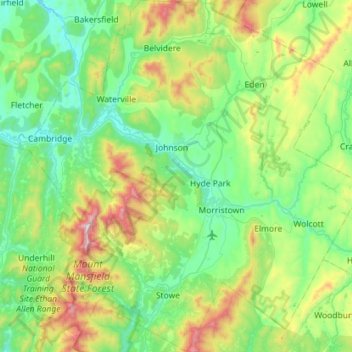
Name: Lamoille County topographic map, elevation, terrain.

Location: Lamoille County, Vermont, United States (44.39831 -72.92728 44.80404 -72.36838)

Average elevation: 1,306 ft

Minimum elevation: 364 ft

Maximum elevation: 4,344 ft

Vermont trails, hiking, mountain biking, running and outdoor activities

Other topographic maps

Click on a map to view its topography, its elevation and its terrain.

Delta Park

United States > Vermont > Chittenden County

Average elevation: 105 ft

Gaysville

United States > Vermont > Windsor County

Average elevation: 1,181 ft

Greenbush

United States > Vermont > Windsor County > Weathersfield

Average elevation: 912 ft

Cady Hill

United States > Vermont > Lamoille County > Stowe

Average elevation: 837 ft

Gore Mountain

United States > Vermont > Essex County > Avery's Gore

Average elevation: 2,648 ft

Mount Philo

United States > Vermont > Chittenden County > Charlotte

Average elevation: 387 ft

Pompanoosuc

United States > Vermont > Windsor County > Norwich

Average elevation: 584 ft

Mount Snow

United States > Vermont > Windham County

Average elevation: 2,838 ft

Essex Center

United States > Vermont > Chittenden County > Essex

Average elevation: 502 ft

Burke Mountain

United States > Vermont > Caledonia County > Burke

Average elevation: 2,159 ft

Gorge

United States > Vermont > Lamoille County > Stowe

Average elevation: 1,732 ft

Cookville

United States > Vermont > Orange County > Corinth

Average elevation: 1,191 ft

New Boston

United States > Vermont > Windsor County > Norwich

Average elevation: 1,056 ft

Wilcox Peak

United States > Vermont > Rutland County > Pittsfield

Average elevation: 1,893 ft

Mill Village

United States > Vermont > Orange County > Vershire

Average elevation: 1,407 ft

Tarbellville

United States > Vermont > Rutland County > Mount Holly

Average elevation: 1,827 ft

Monkton Boro

United States > Vermont > Addison County > Monkton

Average elevation: 591 ft

South Dorset

United States > Vermont > Bennington County

Average elevation: 1,237 ft

Mud Pond

United States > Vermont > Chittenden County > Williston

Average elevation: 745 ft

Millbrook

United States > Vermont > Windsor County > Pomfret

Average elevation: 948 ft

Reedville

United States > Vermont > Windsor County > Chester

Average elevation: 1,178 ft

Braintree Hill

United States > Vermont > Orange County > Braintree

Average elevation: 1,250 ft

Fairfax Falls

United States > Vermont > Franklin County > Fairfax

Average elevation: 492 ft

West Charleston

United States > Vermont > Orleans County > Charleston

Average elevation: 1,266 ft

East Calais

United States > Vermont > Washington County > Calais

Average elevation: 1,102 ft

Folsom

United States > Vermont > Caledonia County > Lyndon

Average elevation: 965 ft

Bald Mountain

United States > Vermont > Essex County > Maidstone

Average elevation: 1,309 ft

Campbell Corner

United States > Vermont > Orange County > Thetford

Average elevation: 1,020 ft

Essex Center

United States > Vermont > Chittenden County > Essex

Average elevation: 502 ft

Packer Corner

United States > Vermont > Windham County > Guilford

Average elevation: 1,001 ft

Morrisville

United States > Vermont > Lamoille County > Morristown

Average elevation: 889 ft

Stevens Mills

United States > Vermont > Franklin County > Richford

Average elevation: 810 ft

Huntsville

United States > Vermont > Franklin County > Fairfax

Average elevation: 617 ft

South Newfane

United States > Vermont > Windham County > Newfane

Average elevation: 1,053 ft

The Alps

United States > Vermont > Windsor County > Reading

Average elevation: 1,808 ft

Annis Hill

United States > Vermont > Orange County > Chelsea

Average elevation: 1,677 ft

South Ryegate

United States > Vermont > Caledonia County > Ryegate

Average elevation: 978 ft

South Cambridge

United States > Vermont > Lamoille County > Cambridge

Average elevation: 1,119 ft

Smuggler's Notch

United States > Vermont > Lamoille County > Cambridge

Average elevation: 2,726 ft

Dutch Hill

United States > Vermont > Rutland County > Danby

Average elevation: 1,732 ft

South Royalton

United States > Vermont > Windsor County

Average elevation: 784 ft

East Burke

United States > Vermont > Caledonia County > Burke

Average elevation: 1,066 ft

Hortonville

United States > Vermont > Rutland County > Mount Holly

Average elevation: 1,631 ft

West Townshend

United States > Vermont > Windham County > Townshend

Average elevation: 968 ft

Sherwood Forest

United States > Vermont > Windham County > Londonderry

Average elevation: 1,371 ft

Corinth Corners

United States > Vermont > Orange County > Corinth

Average elevation: 1,647 ft

Mount Mansfield

United States > Vermont > Chittenden County > Underhill

Mount Mansfield is the highest mountain in Vermont, reaching an elevation of 4,393 feet (1,339 m) above sea level. Located in the northwest of the state, it is also the highest peak in the Green Mountains. Its summit is located within the town of Underhill in Chittenden County; the ridgeline, including some…

Average elevation: 2,999 ft

Caspian Lake

United States > Vermont > Orleans County > Greensboro

Average elevation: 1,444 ft

Thetford

United States > Vermont > Orange County > Thetford

Average elevation: 879 ft

Hanksville

United States > Vermont > Chittenden County > Huntington

Average elevation: 1,398 ft

Williamsville

United States > Vermont > Windham County > Newfane

Average elevation: 886 ft

Jay Peak

United States > Vermont > Orleans County > Westfield

Average elevation: 2,749 ft

Mount Snow

United States > Vermont > Windham County

Average elevation: 2,838 ft

Ascutney

United States > Vermont > Windsor County > Weathersfield > Ascutney

Average elevation: 548 ft

Fernville

United States > Vermont > Addison County > Leicester > Fernville

Average elevation: 794 ft

Lewis Mountain

United States > Vermont > Essex County > Lewis

Average elevation: 2,172 ft

Wilmington

United States > Vermont > Windham County > Wilmington > Wilmington

Wilmington experiences a humid continental climate (Koppen Dfb) with warm, humid summers and cold (sometimes severely cold) winters. While snowfall can vary greatly from year to year in nearby towns like Bennington and Brattleboro, Wilmington's snowfall is consistently heavy each year because of its elevation…

Average elevation: 1,690 ft

Camels Hump

United States > Vermont > Chittenden County > Huntington

The summit of Camel's Hump is home to 10 acres (4 ha) of alpine tundra vegetation. Common plants found in this area include: Bigelow's sedge (Carex bigelowii), alpine bilberry (Vaccinium uliginosum), mountain sandwort (Minuartia groenlandica), crowberry (Empetrum nigrum), mountain cranberry (Vaccinium…

Average elevation: 2,766 ft

Winona Lake

United States > Vermont > Addison County > Bristol

Average elevation: 617 ft

Quechee

United States > Vermont > Windsor County > Hartford

Average elevation: 758 ft

Rutland

United States > Vermont > Rutland County > Rutland

Average elevation: 1,345 ft

Mackville

United States > Vermont > Caledonia County > Hardwick

Average elevation: 1,102 ft

Jay Peak

United States > Vermont > Orleans County > Westfield

Average elevation: 2,749 ft

North Landgrove

United States > Vermont > Landgrove > North Landgrove

Average elevation: 1,509 ft

East Hubbardton

United States > Vermont > Hubbardton > East Hubbardton

Average elevation: 1,099 ft

South Cabot

United States > Vermont > Washington County > Cabot > South Cabot

Average elevation: 1,575 ft

Chester

United States > Vermont > Windsor County > Chester > Chester

Average elevation: 778 ft

Coombs Hill

United States > Vermont > Franklin County > Fletcher

Average elevation: 1,220 ft