
Monroe County topographic map
Interactive map
Click on the map to display elevation.
Monroe County
According to the Trewartha climate classification system, the higher elevation Pocono Plateau Region of Monroe County has a Temperate Continental climate (Dc) with warm summers (b), cold winters (o) and year-around precipitation (Dcbo). Dcbo climates are characterized by at least one month having an average mean temperature ≤ 32.0 °F (0.0 °C), four to seven months with an average mean temperature ≥ 50.0 °F (10.0 °C), all months with an average mean temperature < 72.0 °F (22.2 °C) and no significant precipitation difference between seasons. Although most summer days are comfortably humid on the Pocono Plateau, episodes of heat and high humidity can occur with heat index values > 92 °F (33 °C). Since 1981, the highest air temperature was 93.0 °F (33.9 °C) on 07/15/1995, and the highest daily average mean dew point was 70.8 °F (21.6 °C) on 08/01/2006. July is the peak month for thunderstorm activity which correlates with the average warmest month of the year. Since 1981, the wettest calendar day was 6.43 inches (163 mm) on 09/30/2010. During the winter months, the plant hardiness zone is 5b with an average annual extreme minimum air temperature of −11.2 °F (−24.0 °C). Since 1981, the coldest air temperature was −22.9 °F (−30.5 °C) on 01/21/1994. Episodes of extreme cold and wind can occur with wind chill values < −24 °F (−31 °C). The average snowiest month is January which correlates with the average coldest month of the year. Ice storms and large snowstorms depositing ≥ 12 inches (30 cm) of snow occur nearly every year, particularly during nor’easters from December through March.
About this map
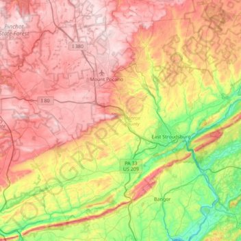
Name: Monroe County topographic map, elevation, terrain.
Location: Monroe County, Pennsylvania, United States (40.81484 -75.64929 41.25213 -74.96660)
Average elevation: 1,184 ft
Minimum elevation: 184 ft
Maximum elevation: 2,244 ft
Pennsylvania trails, hiking, mountain biking, running and outdoor activities
Other topographic maps
Click on a map to view its topography, its elevation and its terrain.
East Texas
United States > Pennsylvania > Lehigh County > Lower Macungie Township
Average elevation: 413 ft
Chadds Ford Township
United States > Pennsylvania > Delaware County > Chadds Ford Township
Average elevation: 331 ft
Strawberry Mansion
United States > Pennsylvania > Philadelphia County > Philadelphia
Average elevation: 102 ft
South Mountain
United States > Pennsylvania > Lehigh County > Upper Saucon
Unlike Blue Mountain to its north, South Mountain does not follow a straight geographic line. The mountain ranges in elevation between 500 and 1,300 feet (150 and 400 m) above sea level. The ridge is made of metamorphic rocks and gneiss, which date to the Precambrian era and range from about 570 million to…
Average elevation: 502 ft
Elk Grove
United States > Pennsylvania > Columbia County > Sugarloaf Township
Average elevation: 1,752 ft
Muncy Valley
United States > Pennsylvania > Sullivan County > Davidson Township
Average elevation: 1,240 ft
Pleasureville
United States > Pennsylvania > York County > Springettsbury Township
Average elevation: 476 ft
Dingmans Ferry
United States > Pennsylvania > Pike County > Delaware Township
Average elevation: 630 ft
Linden
United States > Pennsylvania > Washington County > North Strabane Township
Average elevation: 1,086 ft
Twin Lakes Park
United States > Pennsylvania > Westmoreland County > Hempfield Township > Luxor > Georges Station
Average elevation: 1,204 ft
Circleville
United States > Pennsylvania > Westmoreland County > North Huntingdon Township
Average elevation: 1,093 ft
Baumgardner
United States > Pennsylvania > Lancaster County > Pequea Township
Average elevation: 413 ft
Coopersville
United States > Pennsylvania > Lancaster County > Sadsbury Township
Average elevation: 600 ft
Observatory Hill
United States > Pennsylvania > Allegheny County > Pittsburgh
Average elevation: 1,047 ft
Irving
United States > Pennsylvania > Schuylkill County > Pine Grove Township
Average elevation: 653 ft
Lakeside
United States > Pennsylvania > Susquehanna County > New Milford Township
Average elevation: 1,568 ft
Baptism Creek Spring
United States > Pennsylvania > Chester County > North Coventry Township
Average elevation: 748 ft
Woodhouse
United States > Pennsylvania > Susquehanna County > Dimock Township
Average elevation: 1,365 ft
11th and Pike Playground
United States > Pennsylvania > Berks County > Reading
Average elevation: 433 ft
Roaring Brook
United States > Pennsylvania > Luzerne County > Hunlock Township
Average elevation: 1,106 ft
Mount Zion
United States > Pennsylvania > Cumberland County > South Middleton Township
Average elevation: 587 ft
Nottingham County Park
United States > Pennsylvania > Chester County > West Nottingham Township
Average elevation: 449 ft
Marble Hall
United States > Pennsylvania > Montgomery County > Whitemarsh Township
Average elevation: 210 ft
Parkers Glen
United States > Pennsylvania > Pike County > Shohola Township
Average elevation: 1,007 ft
Mustard
United States > Pennsylvania > Allegheny County > Elizabeth Township
Average elevation: 1,017 ft
Franklinville
United States > Pennsylvania > Montgomery County > Whitpain Township
Average elevation: 308 ft
Allegheny River Lock and Dam No. 2
United States > Pennsylvania > Allegheny County > O'Hara Township
Average elevation: 879 ft
Longwood Gardens
United States > Pennsylvania > Chester County > East Marlborough Township
Average elevation: 410 ft
Blue Mountain
United States > Pennsylvania > Schuylkill County > Washington Township
The ridge of Blue Mountain runs for 150 miles (240 km) through Pennsylvania, reaching an elevation of 2,270 feet (690 m) above sea level just north of the Pennsylvania Turnpike, near the borough of Newburg. Most of the ridgecrest, however, only reaches between 1,400 and 1,700 feet (430 and 520 m) in elevation.…
Average elevation: 741 ft
Gladwyne
United States > Pennsylvania > Montgomery County > Lower Merion Township
Average elevation: 302 ft
Williamsburg
United States > Pennsylvania > Armstrong County > East Franklin Township
Average elevation: 1,047 ft
Stoneybrooke Woods
United States > Pennsylvania > Allegheny County > Cheswick
Average elevation: 928 ft
Blue Ridge
United States > Pennsylvania > Bucks County > Bristol Township > Levittown
Average elevation: 52 ft
Buttonwood
United States > Pennsylvania > Lycoming County > Jackson Township
Average elevation: 1,788 ft
Highland Park Reservoir No. 2
United States > Pennsylvania > Allegheny County > Pittsburgh
Average elevation: 902 ft
Madisonville
United States > Pennsylvania > Lackawanna County > Madison Township
Average elevation: 1,680 ft
Ashmead Village
United States > Pennsylvania > Montgomery County > Cheltenham Township > Cheltenham
Average elevation: 167 ft
Stevens Point
United States > Pennsylvania > Susquehanna County > Harmony Township
Average elevation: 1,424 ft
Pendle Hill
United States > Pennsylvania > Delaware County > Nether Providence Township
Average elevation: 200 ft
Southampton
United States > Pennsylvania > Bucks County > Upper Southampton Township
Average elevation: 246 ft
Atlas
United States > Pennsylvania > Northumberland County > Mount Carmel Township
Average elevation: 1,263 ft
Alverton
United States > Pennsylvania > Westmoreland County > East Huntingdon Township
Average elevation: 1,184 ft
Chestnut Crossroads
United States > Pennsylvania > Cumberland County > Southampton Township
Average elevation: 840 ft
Sunset
United States > Pennsylvania > Lebanon County > North Lebanon Township
Average elevation: 591 ft
Saint Boniface
United States > Pennsylvania > Cambria County > Elder Township
Average elevation: 1,946 ft
Blue Mountain
United States > Pennsylvania > Monroe County > Eldred Township
The ridge of Blue Mountain runs for 150 miles (240 km) through Pennsylvania, reaching an elevation of 2,270 feet (690 m) above sea level just north of the Pennsylvania Turnpike, near the borough of Newburg. Most of the ridgecrest, however, only reaches between 1,400 and 1,700 feet (430 and 520 m) in elevation.…
Average elevation: 794 ft
Horningford
United States > Pennsylvania > Mifflin County > Bratton Township
Average elevation: 663 ft
Park Place
United States > Pennsylvania > Schuylkill County > Mahanoy Township
Average elevation: 1,690 ft
Portlamd Waterfront Park
United States > Pennsylvania > Northampton County > Portland
Average elevation: 387 ft
Atlasburg
United States > Pennsylvania > Washington County > Smith Township
Average elevation: 1,165 ft
Cedars
United States > Pennsylvania > Montgomery County > Worcester Township
Average elevation: 230 ft
Hamburg Reservoir
United States > Pennsylvania > Berks County > Windsor Township
Average elevation: 1,112 ft
Jeffersonville
United States > Pennsylvania > Montgomery County > West Norriton Township
Average elevation: 184 ft
North Springfield
United States > Pennsylvania > Erie County > Springfield Township
Average elevation: 653 ft
Brier Hill
United States > Pennsylvania > Fayette County > Redstone Township
Average elevation: 1,135 ft
Millwood
United States > Pennsylvania > Westmoreland County > Derry Township
Average elevation: 1,335 ft
Millburn
United States > Pennsylvania > Mercer County > Springfield Township
Average elevation: 1,168 ft
Buffington
United States > Pennsylvania > Fayette County > Menallen Township
Average elevation: 1,086 ft
Fort Hunter
United States > Pennsylvania > Dauphin County > Middle Paxton Township
Average elevation: 489 ft
Faylor Lake
United States > Pennsylvania > Snyder County > Spring Township > Beaver Springs
Average elevation: 646 ft
Elders Ridge
United States > Pennsylvania > Indiana County > Young Township
Average elevation: 1,201 ft
Moorestown
United States > Pennsylvania > Northampton County > Moore Township
Average elevation: 719 ft
Elimsport
United States > Pennsylvania > Lycoming County > Washington Township
Average elevation: 630 ft
Grassmere Park
United States > Pennsylvania > Columbia County > Sugarloaf Township
Average elevation: 1,165 ft
Beaver Valley
United States > Pennsylvania > Cambria County > Clearfield Township
Average elevation: 1,614 ft
Bastress
United States > Pennsylvania > Lycoming County > Bastress Township
Average elevation: 1,237 ft
Faylor Lake
United States > Pennsylvania > Snyder County > Spring Township > Beaver Springs
Average elevation: 646 ft
East Waterford
United States > Pennsylvania > Juniata County > Tuscarora Township
Average elevation: 843 ft
Montage Mountain
United States > Pennsylvania > Lackawanna County > Scranton
Average elevation: 1,585 ft
Springtown
United States > Pennsylvania > Luzerne County > Dorrance Township
Average elevation: 1,299 ft
Hickory Run State Park
United States > Pennsylvania > Carbon County > Kidder Township
Average elevation: 1,545 ft