
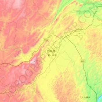
罗平县 topographic map
Interactive map
Click on the map to display elevation.
About this map
Name: 罗平县 topographic map, elevation, terrain.
Location: 罗平县, 曲靖市, 云南省, 中国 (24.72876 104.14535 25.04876 104.46535)
Average elevation: 5,394 ft
Minimum elevation: 2,733 ft
Maximum elevation: 7,982 ft
罗平县境东西宽75公里,南北长99公里,总面积3018平方千米,山区面积占78%,坝区面积占22%,千亩以上的坝子40个。最高点为罗雄镇与九龙镇交界的白腊山,县城罗雄街道,海拔1480米,距省会昆明240公里,距曲靖市区113公里。[2] 南盘江流经南部。 羅平氣候溫和濕潤,夏無酷暑,冬無嚴寒。
Other topographic maps
Click on a map to view its topography, its elevation and its terrain.