
Make a donation
Gear up for your next adventure:
As an Amazon Associate, this site earns from qualifying purchases at no extra cost to you.
Hongyuan County topographic map
Click on the map to display elevation.
Make a donation
Gear up for your next adventure:
As an Amazon Associate, this site earns from qualifying purchases at no extra cost to you.
Hongyuan County
This is the only county under the Prefecture with entirely yak herding pastoralists. The average altitude above the sea level is 3,600 m (11,800 ft). About 8,398 square meter and about 40,000 people reside (2004) mostly Amdo Tibetan. The language is spoken is one of the most conservative dialect among the Amdo Tibetan varieties. The county seat is Kyungqu [zh] (a.k.a. Khyungchu).
Make a donation
Gear up for your next adventure:
As an Amazon Associate, this site earns from qualifying purchases at no extra cost to you.
About this map
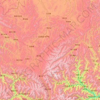
Name: Hongyuan County topographic map, elevation, terrain.
Average elevation: 12,159 ft
Minimum elevation: 5,988 ft
Maximum elevation: 16,857 ft
Make a donation
Gear up for your next adventure:
As an Amazon Associate, this site earns from qualifying purchases at no extra cost to you.
Other topographic maps
Click on a map to view its topography, its elevation and its terrain.
Batang
It is warmer here than most of Tibet (because of the lower altitude) and is reported to be a friendly, easy-going place, surrounded by barley fields. The plain surrounding the town is unusually fertile and produces two harvests a year. The main products include: rice, maize, barley, wheat, peas, cabbages,…
Average elevation: 12,822 ft
Make a donation
Gear up for your next adventure:
As an Amazon Associate, this site earns from qualifying purchases at no extra cost to you.
Make a donation
Gear up for your next adventure:
As an Amazon Associate, this site earns from qualifying purchases at no extra cost to you.
Make a donation
Gear up for your next adventure:
As an Amazon Associate, this site earns from qualifying purchases at no extra cost to you.
Make a donation
Gear up for your next adventure:
As an Amazon Associate, this site earns from qualifying purchases at no extra cost to you.
Mount Gongga
China > Sichuan > Luding County
Mount Gongga (simplified Chinese: 贡嘎山; traditional Chinese: 貢嘎山; pinyin: Gònggá Shān), also known as Minya Konka (Khams Tibetan pinyin: Mi'nyâg Gong'ga Riwo) and colloquially as "The King of Sichuan Mountains", is the highest mountain in Sichuan province, China. It has an elevation of 7,556 m…
Average elevation: 21,342 ft
Garzê Tibetan Autonomous Prefecture
China > Sichuan > Garzê Tibetan Autonomous Prefecture
Average elevation: 12,792 ft
Garze
China > Sichuan > Garzê County
Due to its elevation, Garzê County has a monsoon-influenced humid continental climate (Köppen Dwb) and subarctic climate, with cold but very dry winters, and warm summers with frequent rain. The monthly 24-hour average temperature ranges from −3.9 °C (25.0 °F) in January to 14.2 °C (57.6 °F) in July,…
Average elevation: 13,688 ft
Make a donation
Gear up for your next adventure:
As an Amazon Associate, this site earns from qualifying purchases at no extra cost to you.
Make a donation
Gear up for your next adventure:
As an Amazon Associate, this site earns from qualifying purchases at no extra cost to you.