Geolocate

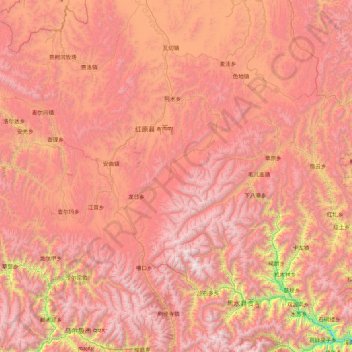
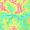
Hongyuan County topographic map

Click on the map to display elevation.

Hongyuan County

This is the only county under the Prefecture with entirely yak herding pastoralists. The average altitude above the sea level is 3,600 m (11,800 ft). About 8,398 square meter and about 40,000 people reside (2004) mostly Amdo Tibetan. The language is spoken is one of the most conservative dialect among the Amdo Tibetan varieties. The county seat is Kyungqu [zh] (a.k.a. Khyungchu).

Wikipedia (CC-BY-SA 3.0)

About this map

Name: Hongyuan County topographic map, elevation, terrain.

Location: Hongyuan County, Ngawa Tibetan and Qiang Autonomous Prefecture, Sichuan, 624400, China (31.85259 101.85188 33.32188 103.34519)

Average elevation: 12,159 ft

Minimum elevation: 5,988 ft

Maximum elevation: 16,857 ft

Other topographic maps

Click on a map to view its topography, its elevation and its terrain.
Hengduan Mountains

China > Sichuan > Kangding

Average elevation: 20,709 ft

Siguniangshan

China > Sichuan > Xiaojin County

Average elevation: 12,369 ft

Batang

China > Sichuan

It is warmer here than most of Tibet (because of the lower altitude) and is reported to be a friendly, easy-going place, surrounded by barley fields. The plain surrounding the town is unusually fertile and produces two harvests a year. The main products include: rice, maize, barley, wheat, peas, cabbages,…

Average elevation: 12,822 ft

Guanyin

China > Sichuan

Average elevation: 1,083 ft

Luzhou

China > Sichuan > Dashanping Subdistrict

Average elevation: 1,037 ft

Mount Gongga

China > Sichuan > Luding County

Mount Gongga (simplified Chinese: 贡嘎山; traditional Chinese: 貢嘎山; pinyin: Gònggá Shān), also known as Minya Konka (Khams Tibetan pinyin: Mi'nyâg Gong'ga Riwo) and colloquially as "The King of Sichuan Mountains", is the highest mountain in Sichuan province, China. It has an elevation of 7,556 m…

Average elevation: 21,342 ft
Ziyang

China > Sichuan > Lianhua Subdistrict

Average elevation: 1,325 ft

Xiqu District

China > Sichuan

Average elevation: 5,230 ft

Golden Peak

China > Sichuan > Emeishan City

Average elevation: 8,045 ft

Mt.Tai

China > Sichuan > Kangding

Average elevation: 18,323 ft

Kanggar

China > Sichuan > Kangding

Average elevation: 13,527 ft

Shambala

China > Sichuan > Xiangcheng County > Shambala

Average elevation: 11,086 ft

Dongda

China > Sichuan > Dêgê County

Average elevation: 12,785 ft

Bölkhül

China > Sichuan

Average elevation: 8,835 ft

Xinglong

China > Sichuan > Chengdu

Average elevation: 1,591 ft

Xiaojin River

China > Sichuan > Danba County > Hongwuyue

Average elevation: 10,095 ft

Yiti

China > Sichuan > Ebian Yi Autonomous County

Average elevation: 6,014 ft

Xuzhou

China > Sichuan > Xuzhou

Average elevation: 1,398 ft

Pingshan

China > Sichuan > Pingshan County > Pingshan > Pingshan

Average elevation: 1,706 ft

Gear up for your next adventure:

🥘Titanium Cookware - Durable, featherlight pots and pans for backpacking
📚Navigation Handbooks - Master the art of reading topographic maps and using a compass
🔥Fast-Boil Camping Stoves - Efficient cooking systems for quick trail meals
⌚Solar GPS Watches - Advanced multisport watches with built-in topographic maps
🚗GPS Dash Cams - Record your scenic drives through mountain passes and canyons

As an Amazon Associate, this site earns from qualifying purchases at no extra cost to you.