
Make a donation
Gear up for your next adventure:
As an Amazon Associate, this site earns from qualifying purchases at no extra cost to you.
Westport topographic map
Click on the map to display elevation.
Make a donation
Gear up for your next adventure:
As an Amazon Associate, this site earns from qualifying purchases at no extra cost to you.
About this map
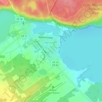
Name: Westport topographic map, elevation, terrain.
Average elevation: 479 ft
Minimum elevation: 384 ft
Maximum elevation: 663 ft
Make a donation
Gear up for your next adventure:
As an Amazon Associate, this site earns from qualifying purchases at no extra cost to you.
Other topographic maps
Click on a map to view its topography, its elevation and its terrain.
Kemptville
Canada > Ontario > Leeds and Grenville Counties > North Grenville
Average elevation: 318 ft
Make a donation
Gear up for your next adventure:
As an Amazon Associate, this site earns from qualifying purchases at no extra cost to you.
Rideau River
Canada > Ontario > Leeds and Grenville Counties > Merrickville > Merrickville-Wolford
Average elevation: 358 ft
Make a donation
Gear up for your next adventure:
As an Amazon Associate, this site earns from qualifying purchases at no extra cost to you.
Elizabethtown
Canada > Ontario > Leeds and Grenville Counties > Elizabethtown-Kitley
Average elevation: 361 ft
Mallorytown Landing
Canada > Ontario > Leeds and Grenville Counties > Front of Yonge
Average elevation: 282 ft
Groveton
Canada > Ontario > Leeds and Grenville Counties > Edwardsburgh/Cardinal
Average elevation: 325 ft
Opinicon Lake
Canada > Ontario > Leeds and Grenville Counties > Rideau Lakes
Average elevation: 436 ft
Make a donation
Gear up for your next adventure:
As an Amazon Associate, this site earns from qualifying purchases at no extra cost to you.
Leeds and the Thousand Islands
Canada > Ontario > Leeds and Grenville Counties
Average elevation: 335 ft
Seeleys Bay
Canada > Ontario > Leeds and Grenville Counties > Leeds and the Thousand Islands > Seeley's Bay
Average elevation: 344 ft
Make a donation
Gear up for your next adventure:
As an Amazon Associate, this site earns from qualifying purchases at no extra cost to you.
Whitefish Lake
Canada > Ontario > Leeds and Grenville Counties > Rideau Lakes
Average elevation: 400 ft
Johnstown
Canada > Ontario > Leeds and Grenville Counties > Edwardsburgh/Cardinal
Average elevation: 272 ft
Make a donation
Gear up for your next adventure:
As an Amazon Associate, this site earns from qualifying purchases at no extra cost to you.
Edwardsburgh
Canada > Ontario > Leeds and Grenville Counties > Edwardsburgh/Cardinal
Average elevation: 302 ft
Lansdowne
Canada > Ontario > Leeds and Grenville Counties > Leeds and the Thousand Islands
Average elevation: 331 ft
Wolford
Canada > Ontario > Leeds and Grenville Counties > Merrickville-Wolford
Average elevation: 371 ft
Make a donation
Gear up for your next adventure:
As an Amazon Associate, this site earns from qualifying purchases at no extra cost to you.
Harvey Island
Canada > Ontario > Leeds and Grenville Counties > Elizabethtown-Kitley
Average elevation: 364 ft
Cardinal
Canada > Ontario > Leeds and Grenville Counties > Edwardsburgh/Cardinal
Average elevation: 269 ft
Make a donation
Gear up for your next adventure:
As an Amazon Associate, this site earns from qualifying purchases at no extra cost to you.
Tincap
Canada > Ontario > Leeds and Grenville Counties > Elizabethtown-Kitley
Average elevation: 371 ft
Actons Corners
Canada > Ontario > Leeds and Grenville Counties > North Grenville
Average elevation: 318 ft
Charleston Lake
Canada > Ontario > Leeds and Grenville Counties > Leeds and the Thousand Islands > Outlet
Average elevation: 338 ft
Frankville
Canada > Ontario > Leeds and Grenville Counties > Elizabethtown-Kitley
Average elevation: 387 ft
Make a donation
Gear up for your next adventure:
As an Amazon Associate, this site earns from qualifying purchases at no extra cost to you.
Merrickville
Canada > Ontario > Leeds and Grenville Counties > Merrickville-Wolford
Average elevation: 374 ft
Oxford-on-Rideau
Canada > Ontario > Leeds and Grenville Counties > North Grenville
Average elevation: 338 ft
South Gower
Canada > Ontario > Leeds and Grenville Counties > North Grenville
Average elevation: 305 ft
Make a donation
Gear up for your next adventure:
As an Amazon Associate, this site earns from qualifying purchases at no extra cost to you.
Upper Rideau Lake
Canada > Ontario > Leeds and Grenville Counties > Rideau Lakes > Newboro
Average elevation: 486 ft
Thousand Islands National Park
Canada > Ontario > Leeds and Grenville Counties > Leeds and the Thousand Islands > Rockport
Average elevation: 381 ft
Gananoque Lake
Canada > Ontario > Leeds and Grenville Counties > Leeds and the Thousand Islands
Average elevation: 302 ft
Make a donation
Gear up for your next adventure:
As an Amazon Associate, this site earns from qualifying purchases at no extra cost to you.
Spencerville
Canada > Ontario > Leeds and Grenville Counties > Edwardsburgh/Cardinal
Average elevation: 325 ft
Oxford Mills
Canada > Ontario > Leeds and Grenville Counties > North Grenville
Average elevation: 338 ft
Toledo
Canada > Ontario > Leeds and Grenville Counties > Elizabethtown-Kitley
Average elevation: 397 ft
Make a donation
Gear up for your next adventure:
As an Amazon Associate, this site earns from qualifying purchases at no extra cost to you.
Waterton
Canada > Ontario > Leeds and Grenville Counties > Leeds and the Thousand Islands > Waterton
Average elevation: 318 ft
Seeley's Bay
Canada > Ontario > Leeds and Grenville Counties > Leeds and the Thousand Islands
Average elevation: 348 ft
Crosby
Canada > Ontario > Leeds and Grenville Counties > Rideau Lakes > Crosby
Average elevation: 420 ft
Leeds
Canada > Ontario > Leeds and Grenville Counties > Leeds and the Thousand Islands
Average elevation: 341 ft
Make a donation
Gear up for your next adventure:
As an Amazon Associate, this site earns from qualifying purchases at no extra cost to you.
Greenbush
Canada > Ontario > Leeds and Grenville Counties > Elizabethtown-Kitley > Greenbush
Average elevation: 394 ft
Motts Mills
Canada > Ontario > Leeds and Grenville Counties > Elizabethtown-Kitley
Average elevation: 413 ft
Make a donation
Gear up for your next adventure:
As an Amazon Associate, this site earns from qualifying purchases at no extra cost to you.
Leeds
Canada > Ontario > Leeds and Grenville Counties > Leeds and the Thousand Islands
Average elevation: 341 ft
Seeleys Bay
Canada > Ontario > Leeds and Grenville Counties > Leeds and the Thousand Islands > Seeley's Bay
Average elevation: 344 ft
Outlet
Canada > Ontario > Leeds and Grenville Counties > Leeds and the Thousand Islands
Average elevation: 318 ft
Make a donation
Gear up for your next adventure:
As an Amazon Associate, this site earns from qualifying purchases at no extra cost to you.
Glen Buell
Canada > Ontario > Leeds and Grenville Counties > Elizabethtown-Kitley
Average elevation: 394 ft
Cardinal
Canada > Ontario > Leeds and Grenville Counties > Edwardsburgh/Cardinal
Average elevation: 269 ft
Make a donation
Gear up for your next adventure:
As an Amazon Associate, this site earns from qualifying purchases at no extra cost to you.