
Zaporizhia Oblast topographic map
Interactive map
Click on the map to display elevation.
Zaporizhia Oblast
The territory of Zaporizhzhia Oblast as a whole has a flat topography, but there are markedly elevated and depressed areas, which differ in shape, origin, and age.
About this map
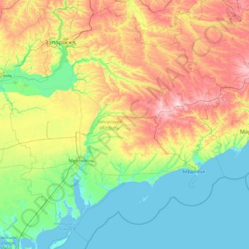
Name: Zaporizhia Oblast topographic map, elevation, terrain.
Location: Zaporizhia Oblast, Ukraine (46.14649 34.13946 48.14493 37.24863)
Average elevation: 246 ft
Minimum elevation: -13 ft
Maximum elevation: 1,037 ft
Other topographic maps
Click on a map to view its topography, its elevation and its terrain.
Dnipro
The source of the Dnieper is the sedge bogs (Akseninsky Mokh) of the Valdai Hills in central Russia, at an elevation of 220 m (720 ft). For 115 km (71 mi) of its length, it serves as the border between Belarus and Ukraine. Its estuary, or liman, used to be defended by the strong fortress of Ochakiv.
Average elevation: 354 ft
Lineinoe
Ukraine > Autonomous Republic of Crimea > Yalta city municipality
Liniine is located on Crimea's southern shore at an elevation of 216 metres (709 ft). The settlement is located 5 km (3.1 mi) southwest from Hurzuf, which it is administratively subordinate to. Its population was 31 in the 2001 Ukrainian census. Current population: 30 (2014 Census).
Average elevation: 797 ft
Kyiv
Originally on the west bank, today Kyiv is on both sides of the Dnieper, which flows southwards through the city towards the Black Sea. The older and higher western part of the city sits on numerous wooded hills (Kyiv Hills), with ravines and small rivers. Kyiv's geographical relief contributed to its…
Average elevation: 430 ft
Bukovel
Ukraine > Ivano-Frankivsk Oblast > Polianytsia
Bukovel (Ukrainian: Буковель) is the largest ski resort in Eastern Europe situated in Ukraine, in Nadvirna Raion, Ivano-Frankivsk Oblast (province) of western Ukraine. A part of it is in state property. The resort is located almost on the ridge-lines of the Carpathian Mountains at elevation of 900 m…
Average elevation: 3,343 ft