
Dundalk topographic map
Interactive map
Click on the map to display elevation.
About this map
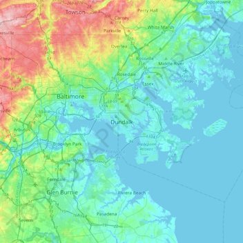
Name: Dundalk topographic map, elevation, terrain.
Location: Dundalk, Baltimore County, Maryland, 21222, United States (39.09741 -76.68367 39.41741 -76.36367)
Average elevation: 108 ft
Minimum elevation: -10 ft
Maximum elevation: 568 ft
Most of Dundalk is flat and very near sea level, with a few small hills close to the city of Baltimore to the west. Dundalk is part of the Atlantic Coastal Plain. Elevations range from sea level on the shore of the Chesapeake Bay to approximately 40 feet (12 m) above sea level along the northern reaches of Dundalk Avenue and North Point Boulevard.
Other topographic maps
Click on a map to view its topography, its elevation and its terrain.
Catonsville
United States > Maryland > Baltimore County
Catonsville, Baltimore County, Maryland, 21228, United States
Average elevation: 341 ft
Hereford
United States > Maryland > Baltimore County
Hereford, Baltimore County, Maryland, United States
Average elevation: 558 ft
Perry Hall
United States > Maryland > Baltimore County
Perry Hall, Baltimore County, Maryland, 21236, United States
Average elevation: 236 ft
Cockeysville
United States > Maryland > Baltimore County
Cockeysville, Baltimore County, Maryland, 21031, United States
Average elevation: 430 ft
Kingsville
United States > Maryland > Baltimore County
Kingsville, Baltimore County, Maryland, 21087, United States
Average elevation: 272 ft
Hydes
United States > Maryland > Baltimore County > Towson
Hydes, Towson, Baltimore County, Maryland, 21013, United States
Average elevation: 404 ft
Jacksonville
United States > Maryland > Baltimore County
Jacksonville, Baltimore County, Maryland, 21131, United States
Average elevation: 558 ft
Upperco
United States > Maryland > Baltimore County
Upperco, Baltimore County, Maryland, 21155, United States
Average elevation: 715 ft
Edgemere
United States > Maryland > Baltimore County
Edgemere, Baltimore County, Maryland, 21219, United States
Average elevation: 13 ft
Maryland Line
United States > Maryland > Baltimore County
Maryland Line, Baltimore County, Maryland, 21105, United States
Average elevation: 801 ft
Oregon
United States > Maryland > Baltimore County
Oregon, Baltimore County, Maryland, 21031, United States
Average elevation: 446 ft
Randallstown
United States > Maryland > Baltimore County
Randallstown, Baltimore County, Maryland, 21133, United States
Average elevation: 495 ft
Honeygo
United States > Maryland > Baltimore County
Honeygo, Baltimore County, Maryland, 21162, United States
Average elevation: 154 ft
Riderwood
United States > Maryland > Baltimore County
Riderwood, Baltimore County, Maryland, 21139, United States
Average elevation: 348 ft
Lutherville
United States > Maryland > Baltimore County
Lutherville, Baltimore County, Maryland, 21204, United States
Average elevation: 384 ft
Milford Mill
United States > Maryland > Baltimore County
Milford Mill, Baltimore County, Maryland, 21244, United States
Average elevation: 456 ft
Boring
United States > Maryland > Baltimore County
Boring, Baltimore County, Maryland, 21020, United States
Average elevation: 633 ft
Butler
United States > Maryland > Baltimore County
Butler, Baltimore County, Maryland, 21023, United States
Average elevation: 440 ft
Shepperd
United States > Maryland > Baltimore County
Shepperd, Baltimore County, Maryland, 21111, United States
Average elevation: 574 ft
Relay
United States > Maryland > Baltimore County
Relay, Baltimore County, Maryland, 21227, United States
Average elevation: 131 ft
White Hall
United States > Maryland > Baltimore County
White Hall, Baltimore County, Maryland, 21161, United States
Average elevation: 479 ft
Arbutus
United States > Maryland > Baltimore County
Arbutus, Baltimore County, Maryland, 21227, United States
Average elevation: 187 ft
Fork
United States > Maryland > Baltimore County > Kingsville
Fork, Kingsville, Baltimore County, Maryland, 21051, United States
Average elevation: 394 ft
Hart-Miller Island State Park
United States > Maryland > Baltimore County
Hart-Miller Island State Park, Baltimore County, Maryland, United States
Average elevation: 3 ft
Overlea
United States > Maryland > Baltimore County
Overlea, Baltimore County, Maryland, 21026, United States
Average elevation: 210 ft
Hampton
United States > Maryland > Baltimore County
Hampton, Baltimore County, Maryland, 21286, United States
Average elevation: 387 ft
Brooklandville
United States > Maryland > Baltimore County > Towson
Brooklandville, Towson, Baltimore County, Maryland, 21022, United States
Average elevation: 400 ft
Soldiers Delight Natural Environment Area
United States > Maryland > Baltimore County > Owings Mills
Soldiers Delight Natural Environment Area, Red Run Boulevard, Belltown, Owings Mills, Baltimore County, Maryland, 21117, United States
Average elevation: 614 ft
Rossville
United States > Maryland > Baltimore County > Rossville
Rossville, Baltimore County, Maryland, 21326, United States
Average elevation: 108 ft
Marshy Point
United States > Maryland > Baltimore County
Marshy Point, Baltimore County, Maryland, 21027, United States
Average elevation: 3 ft
Middle River
United States > Maryland > Baltimore County > Middle River
Middle River, Baltimore County, Maryland, 21220, United States
Average elevation: 43 ft
Cockeysville
United States > Maryland > Baltimore County > Cockeysville
Cockeysville, Baltimore County, Maryland, United States
Average elevation: 394 ft
Lutherville
United States > Maryland > Baltimore County > Lutherville
Lutherville, Baltimore County, Maryland, United States
Average elevation: 381 ft
Reisterstown
United States > Maryland > Baltimore County
Reisterstown, Baltimore County, Maryland, 21136, United States
Average elevation: 600 ft
Parkville
United States > Maryland > Baltimore County > Parkville
Parkville, Baltimore County, Maryland, 21234, United States
Average elevation: 364 ft
Parkton
United States > Maryland > Baltimore County
Parkton, Baltimore County, Maryland, 21120, United States
Average elevation: 545 ft
Pikesville
United States > Maryland > Baltimore County > Pikesville
Pikesville, Baltimore County, Maryland, United States
Average elevation: 443 ft
Carney
United States > Maryland > Baltimore County > Oakleigh
Carney, Oakleigh, Baltimore County, Maryland, United States
Average elevation: 338 ft
Essex
United States > Maryland > Baltimore County
Essex, Baltimore County, Maryland, 21221, United States
Average elevation: 46 ft
Dundalk
United States > Maryland > Baltimore County > North Point Village
Dundalk, North Point Village, Baltimore County, Maryland, 21222, United States
Average elevation: 20 ft
Baldwin
United States > Maryland > Baltimore County
Baldwin, Baltimore County, Maryland, 21082, United States
Average elevation: 427 ft
Yeoho
United States > Maryland > Baltimore County
Yeoho, Baltimore County, Maryland, 21023, United States
Average elevation: 591 ft
Kingsville
United States > Maryland > Baltimore County > Kingsville
Kingsville, Baltimore County, Maryland, 21087, United States
Average elevation: 279 ft
Arbutus
United States > Maryland > Baltimore County > Relay
Arbutus, Relay, Baltimore County, Maryland, United States
Average elevation: 138 ft
Hoffmanville
United States > Maryland > Baltimore County > Hoffmanville
Hoffmanville, Baltimore County, Maryland, 21088, United States
Average elevation: 732 ft
Timonium
United States > Maryland > Baltimore County > Timonium
Timonium, Baltimore County, Maryland, United States
Average elevation: 371 ft
White Marsh
United States > Maryland > Baltimore County > White Marsh
White Marsh, Baltimore County, Maryland, United States
Average elevation: 128 ft
Pikesville
United States > Maryland > Baltimore County
Pikesville, Baltimore County, Maryland, 21208, United States
Average elevation: 463 ft
Bowleys Quarters
United States > Maryland > Baltimore County > Bowleys Quarters
Bowleys Quarters, Baltimore County, Maryland, United States
Average elevation: 7 ft
Phoenix
United States > Maryland > Baltimore County
Phoenix, Baltimore County, Maryland, 21030, United States
Average elevation: 404 ft