Geolocate

Phoenix topographic map

Click on the map to display elevation.

About this map

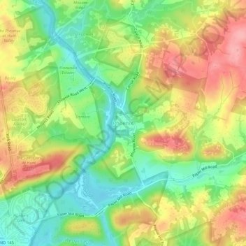
Name: Phoenix topographic map, elevation, terrain.

Location: Phoenix, Baltimore County, Maryland, 21030, United States (39.49639 -76.63778 39.53639 -76.59778)

Average elevation: 404 ft

Minimum elevation: 233 ft

Maximum elevation: 594 ft

Baltimore County trails, hiking, mountain biking, running and outdoor activities

Other topographic maps

Click on a map to view its topography, its elevation and its terrain.

Lansdowne

United States > Maryland > Baltimore County > Lansdowne

Average elevation: 79 ft

Arbutus

United States > Maryland > Baltimore County > Arbutus

Average elevation: 138 ft

Mingo Branch

United States > Maryland > Baltimore County

Average elevation: 535 ft

Overlea

United States > Maryland > Baltimore County > Overlea

Average elevation: 207 ft

Kingsville

United States > Maryland > Baltimore County > Kingsville

Average elevation: 279 ft

Carney

United States > Maryland > Baltimore County > Carney

Average elevation: 338 ft

Gear up for your next adventure:

🔥Fast-Boil Camping Stoves - Efficient cooking systems for quick trail meals
🎁Geography Themed Gifts - Unique gift ideas for map lovers and geography enthusiasts
🔥Plasma Lighters - Windproof lighters that work in any weather condition
🛠️Backpacking Tool Kit - Essential toolkit for outdoor repairs
🔦Compact Flashlight - Reliable flashlight for emergencies

As an Amazon Associate, this site earns from qualifying purchases at no extra cost to you.