
Kgatleng District topographic map
Interactive map
Click on the map to display elevation.
About this map
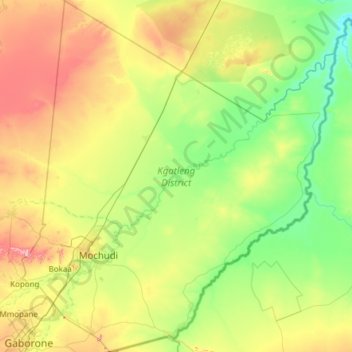
Name: Kgatleng District topographic map, elevation, terrain.
Location: Kgatleng District, Botswana (-24.68678 25.88393 -23.58114 26.96549)
Average elevation: 3,156 ft
Minimum elevation: 2,740 ft
Maximum elevation: 4,295 ft
Kgatleng borders the North West Province of South Africa in the south, and to the east it borders South Africa's Limpopo Province. Domestically, it borders South-East District in southwest, Kweneng District in the west, Central District in north. Most part of Botswana has tableland slopes sliding from east to west. The region has an average elevation of around 915 m (3,002 ft) above the mean sea level. The vegetation type is Savannah, with tall grasses, bushes and trees. The annual precipitation is around 55 cm (22 in), most of which is received during the summer season from November to May. Most of the rivers in the region are seasonal which are prone to flash floods, being the most prominent. The tourist and game reserves in the region are Oodi Weavers and Matsieng footprints.
Other topographic maps
Click on a map to view its topography, its elevation and its terrain.
Gaborone
Botswana > South-East District
Gaborone, South-East District, Botswana
Average elevation: 3,386 ft
Kalahari Desert
Kalahari Desert, Ghanzi District, Botswana
Average elevation: 3,832 ft
Segoditshane River
Botswana > South-East District > Gaborone
Segoditshane River, Gaborone, South-East District, Botswana
Average elevation: 3,241 ft
Goshwe
Botswana > Central District > Goshwe
Goshwe, Central District, Botswana
Average elevation: 3,845 ft
Francistown
Botswana > North-East District
Francistown, North-East District, Botswana
Average elevation: 3,304 ft
Pandamatenga
Botswana > Chobe District > Pandamatenga
Pandamatenga, Chobe District, Botswana
Average elevation: 3,524 ft
Okavango Delta
Botswana > North-West District
Okavango Delta, North-West District, Botswana
Average elevation: 3,133 ft
Gaborone Dam
Botswana > South-East District > Gaborone
Gaborone Dam, Gaborone, South-East District, Botswana
Average elevation: 3,255 ft