
Kgalagadi District topographic map
Interactive map
Click on the map to display elevation.
About this map
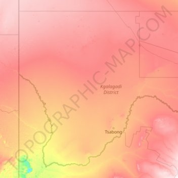
Name: Kgalagadi District topographic map, elevation, terrain.
Location: Kgalagadi District, Botswana (-26.90701 19.99865 -23.31852 24.50817)
Average elevation: 3,481 ft
Minimum elevation: 2,582 ft
Maximum elevation: 4,587 ft
Kgalagadi borders Omaheke Region, Namibia in the northwest, Hardap Region, Namibia in the southwest, Northern Cape Province, South Africa in the south, North West Province, South Africa in the southeast and domestically, Ghanzi District in the north, Kweneng District in the northeast, and Southern District in the east. Kgalagadi means "land of the thirst". The largest settlement in the district is Tsabong, which had a population of 8939 in 2011 census while Hukuntsi and Kang had 4654 and 5985, respectively. Most part of Botswana has tableland slopes sliding from east to west. The region has an average elevation of around 915 m (3,002 ft) above the mean sea level. The vegetation type is Savannah, with tall grasses, bushes and trees. The annual precipitation is around 25 cm (9.8 in), most of which is received during the summer season from November to May. Most of the rivers in the region are seasonal, with Limpopo River, which are prone to flash floods, being the most prominent. The tourist and game reserves in the region are Ghanzi, Central Kalahari Game Reserve, Deception Valley, Ghanzi Craft, Kgalagadi Transfrontier Park, Khutse Game Reserve and Kuru Museum and Cultural Centre.
Other topographic maps
Click on a map to view its topography, its elevation and its terrain.
Gaborone
Botswana > South-East District
Gaborone, South-East District, Botswana
Average elevation: 3,386 ft
Kalahari Desert
Kalahari Desert, Ghanzi District, Botswana
Average elevation: 3,832 ft
Segoditshane River
Botswana > South-East District > Gaborone
Segoditshane River, Gaborone, South-East District, Botswana
Average elevation: 3,241 ft
Goshwe
Botswana > Central District > Goshwe
Goshwe, Central District, Botswana
Average elevation: 3,845 ft
Francistown
Botswana > North-East District
Francistown, North-East District, Botswana
Average elevation: 3,304 ft
Pandamatenga
Botswana > Chobe District > Pandamatenga
Pandamatenga, Chobe District, Botswana
Average elevation: 3,524 ft
Okavango Delta
Botswana > North-West District
Okavango Delta, North-West District, Botswana
Average elevation: 3,133 ft
Gaborone Dam
Botswana > South-East District > Gaborone
Gaborone Dam, Gaborone, South-East District, Botswana
Average elevation: 3,255 ft