
Make a donation
Gear up for your next adventure:
As an Amazon Associate, this site earns from qualifying purchases at no extra cost to you.
Al Ardiyat topographic map
Click on the map to display elevation.
Make a donation
Gear up for your next adventure:
As an Amazon Associate, this site earns from qualifying purchases at no extra cost to you.
About this map
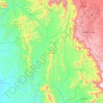
Name: Al Ardiyat topographic map, elevation, terrain.
Location: Al Ardiyat, Makkah Region, Saudi Arabia (19.10172 41.51216 19.76905 41.95269)
Average elevation: 2,631 ft
Minimum elevation: 292 ft
Maximum elevation: 8,862 ft
Make a donation
Gear up for your next adventure:
As an Amazon Associate, this site earns from qualifying purchases at no extra cost to you.
Other topographic maps
Click on a map to view its topography, its elevation and its terrain.
Mecca
Saudi Arabia > Makkah Region > Makkah Al Mukarramah > Mecca
Mecca is at an elevation of 277 m (909 ft) above sea level, and approximately 80 km (50 mi) inland from the Red Sea. Central Mecca lies in a corridor between mountains, which is often called the "Hollow of Mecca". The area contains the valley of Al Taneem, the Valley of Bakkah and the valley of Abqar. This…
Average elevation: 1,027 ft
Make a donation
Gear up for your next adventure:
As an Amazon Associate, this site earns from qualifying purchases at no extra cost to you.
Turabah
Turabah (Arabic: تربة, also spelled turaba, turba or tarba) is a city in Najd in Saudi Arabia, located in the valley of the same name. Turubah is located south of the mountain of Hadhn ("Jebel Hadhn"), to the southeast of Mecca. It is therefore considered on the border between the topographic regions of…
Average elevation: 3,809 ft
Make a donation
Gear up for your next adventure:
As an Amazon Associate, this site earns from qualifying purchases at no extra cost to you.
Make a donation
Gear up for your next adventure:
As an Amazon Associate, this site earns from qualifying purchases at no extra cost to you.