
Culleredo topographic map
Click on the map to display elevation.
Culleredo
El relieve del municipio está fuertemente marcado por la ría del Burgo, en la desembocadura del río Mero, y por la sierra que cierra el municipio al sur, que incluye el monte do Castro (436 m) y los montes do Xalo (514 m), aunque el monte da Zapateira (236 m), situado al noroeste, también marca un contraste geográfico. Una sucesión de arroyos salpican el pueblo y vierten sus aguas en los ríos principales, el río Mero y el río Valiñas, afluente del anterior. El aeropuerto de La Coruña se ubica en el territorio municipal. La altitud oscila entre los 515 m (Montes do Xalo) y el nivel del mar en la ría del Burgo. El pueblo se alza a 80 m sobre el nivel del mar.
About this map
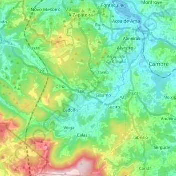
Name: Culleredo topographic map, elevation, terrain.
Location: Culleredo, La Coruña, Galicia, España (43.22511 -8.47002 43.33055 -8.35328)
Average elevation: 456 ft
Minimum elevation: 0 ft
Maximum elevation: 1,703 ft
Other topographic maps
Click on a map to view its topography, its elevation and its terrain.