
Somerset topographic map
Interactive map
Click on the map to display elevation.
About this map
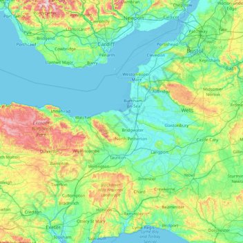
Name: Somerset topographic map, elevation, terrain.
Location: Somerset, England, United Kingdom (50.82084 -3.83980 51.50269 -2.24440)
Average elevation: 315 ft
Minimum elevation: -13 ft
Maximum elevation: 1,844 ft
Many settlements developed because of their strategic importance in relation to geographical features, such as river crossings or valleys in ranges of hills. Examples include Axbridge on the River Axe, Castle Cary on the River Cary, North Petherton on the River Parrett, and Ilminster, where there was a crossing point on the River Isle. Midsomer Norton lies on the River Somer; while the Wellow Brook and the Fosse Way Roman road run through Radstock. Chard is the most southerly town in Somerset and one of the highest, though at an altitude of 126 m (413 ft) Wiveliscombe is the highest town in the county.
Other topographic maps
Click on a map to view its topography, its elevation and its terrain.
Water
United Kingdom > England > Devon > Teignbridge
Water, Teignbridge, Devon, England, TQ13 9UE, United Kingdom
Average elevation: 856 ft
City of London
United Kingdom > England > City of London > City of London
City of London, England, EC2V 5AE, United Kingdom
Average elevation: 138 ft
Hanham
United Kingdom > England > South Gloucestershire
Hanham, South Gloucestershire, West of England, England, United Kingdom
Average elevation: 233 ft
Offham
United Kingdom > England > Kent > Tonbridge and Malling
Offham, Tonbridge and Malling, Kent, England, United Kingdom
Average elevation: 315 ft
Woolavington
United Kingdom > England > Somerset
Woolavington, Somerset, England, United Kingdom
Average elevation: 56 ft
Coseley
Coseley, Dudley, West Midlands Combined Authority, England, WV14 9NJ, United Kingdom
Average elevation: 509 ft
Cruwys Morchard
United Kingdom > England > Devon > Mid Devon
Cruwys Morchard, Mid Devon, Devon, England, United Kingdom
Average elevation: 636 ft
Alveley
United Kingdom > England > Shropshire
Alveley, Shropshire, England, WV15 6PQ, United Kingdom
Average elevation: 335 ft
Elsdon
United Kingdom > England > Northumberland
Elsdon, Northumberland, North of Tyne, England, United Kingdom
Average elevation: 807 ft
Landican
United Kingdom > England > Thingwall
Landican, Thingwall, Wirral, Liverpool City Region, England, CH49 5LJ, United Kingdom
Average elevation: 148 ft
Goring-on-Thames
United Kingdom > England > Oxfordshire > South Oxfordshire
Goring-on-Thames, South Oxfordshire, Oxfordshire, England, RG8 0EB, United Kingdom
Average elevation: 276 ft
London
London, Greater London, England, United Kingdom
Average elevation: 217 ft
Codsall
United Kingdom > England > Staffordshire > South Staffordshire
Codsall, South Staffordshire, Staffordshire, England, United Kingdom
Average elevation: 407 ft
Allesley
United Kingdom > England > Coventry
Allesley, Coventry, West Midlands Combined Authority, England, CV5 9GS, United Kingdom
Average elevation: 377 ft
Sunderland
Sunderland, North East, England, United Kingdom
Average elevation: 151 ft
Tetbury
United Kingdom > England > Gloucestershire > Cotswold District
Tetbury, Cotswold District, Gloucestershire, England, United Kingdom
Average elevation: 400 ft
Stonehenge
United Kingdom > England > Larkhill
Stonehenge, The Avenue, Amesbury, Larkhill, Wiltshire, South West England, England, SP3 4DX, United Kingdom
Average elevation: 325 ft
Rotherham
Rotherham, South Yorkshire Mayoral Combined Authority, England, United Kingdom
Average elevation: 331 ft
Carlisle
United Kingdom > England > Cumberland
Carlisle, Cumberland, England, United Kingdom
Average elevation: 102 ft
White Cliffs of Dover
United Kingdom > England > Kent > Dover > St. Margaret's at Cliffe
White Cliffs of Dover, St. Margaret's at Cliffe, Dover, Kent, England, United Kingdom
Average elevation: 161 ft
Shrewsbury
United Kingdom > England > Shrewsbury
Shrewsbury, Shropshire, West Midlands, England, SY1 1SF, United Kingdom
Average elevation: 233 ft
Welford
United Kingdom > England > West Berkshire
Welford, West Berkshire, England, United Kingdom
Average elevation: 407 ft
Northampton
United Kingdom > England > West Northamptonshire > Northampton
Northampton, West Northamptonshire, England, United Kingdom
Average elevation: 292 ft
Olveston
United Kingdom > England > South Gloucestershire
Olveston, South Gloucestershire, West of England, England, United Kingdom
Average elevation: 102 ft
Royal Leamington Spa
United Kingdom > England > Royal Leamington Spa
Royal Leamington Spa, Warwickshire, West Midlands, England, CV32 4DB, United Kingdom
Average elevation: 223 ft
Fenny Bentley CP
United Kingdom > England > Derbyshire > Derbyshire Dales
Fenny Bentley CP, Derbyshire Dales, Derbyshire, England, United Kingdom
Average elevation: 633 ft
Derbyshire Dales
United Kingdom > England > Derbyshire
Derbyshire Dales, Derbyshire, England, United Kingdom
Average elevation: 650 ft
Alfreton Park
United Kingdom > England > Derbyshire > Amber Valley > Alfreton CP > Oakerthorpe
Alfreton Park, Alfreton CP, Oakerthorpe, Amber Valley, Derbyshire, England, DE55 7AL, United Kingdom
Average elevation: 381 ft
Elveden
United Kingdom > England > Suffolk > West Suffolk
Elveden, West Suffolk, Suffolk, England, United Kingdom
Average elevation: 141 ft
Kingsley Holt
United Kingdom > England > Staffordshire > Staffordshire Moorlands
Kingsley Holt, Staffordshire Moorlands, Staffordshire, England, ST10 2BG, United Kingdom
Average elevation: 604 ft
Dalbury
United Kingdom > England > Derbyshire > South Derbyshire
Dalbury, Dalbury Lees CP, South Derbyshire, Derbyshire, England, DE6 5BR, United Kingdom
Average elevation: 249 ft
West Tytherley
United Kingdom > England > Hampshire > Test Valley
West Tytherley, Test Valley, Hampshire, England, United Kingdom
Average elevation: 240 ft
Cusworth
United Kingdom > England > Doncaster
Cusworth, Doncaster, South Yorkshire, England, DN5 8UZ, United Kingdom
Average elevation: 82 ft
Goblin Ledge
United Kingdom > England > South Gloucestershire > Severn Beach > New Passage
Goblin Ledge, Prince of Wales Bridge, New Passage, Pilning and Severn Beach, Severn Beach, South Gloucestershire, West of England, England, BS35 4NQ, United Kingdom
Average elevation: 7 ft
Amport
United Kingdom > England > Hampshire > Test Valley
Amport, Test Valley, Hampshire, England, United Kingdom
Average elevation: 312 ft
Hazelwood CP
United Kingdom > England > Derbyshire > Amber Valley
Hazelwood CP, Amber Valley, Derbyshire, England, United Kingdom
Average elevation: 361 ft
Lew
United Kingdom > England > Oxfordshire > West Oxfordshire
Lew, West Oxfordshire, Oxfordshire, England, United Kingdom
Average elevation: 259 ft
Crediton
United Kingdom > England > Devon > Mid Devon
Crediton, Mid Devon, Devon, England, United Kingdom
Average elevation: 233 ft
Hadfield
United Kingdom > England > Derbyshire > High Peak
Hadfield, High Peak, Derbyshire, England, United Kingdom
Average elevation: 571 ft
Whitby
United Kingdom > England > Whitby
Whitby, North Yorkshire, Yorkshire and the Humber, England, YO21 3QF, United Kingdom
Average elevation: 128 ft
Alvescot
United Kingdom > England > Oxfordshire > West Oxfordshire
Alvescot, West Oxfordshire, Oxfordshire, England, United Kingdom
Average elevation: 285 ft
River Glen
United Kingdom > England > Northumberland > Kirknewton
River Glen, Kirknewton, Northumberland, North of Tyne, England, United Kingdom
Average elevation: 318 ft
Cambourne
United Kingdom > England > Cambridgeshire > South Cambridgeshire
Cambourne, South Cambridgeshire, Cambridgeshire, Cambridgeshire and Peterborough, England, United Kingdom
Average elevation: 207 ft
Yorkshire Dales National Park
Yorkshire Dales National Park, England, United Kingdom
Average elevation: 978 ft
Muckleford
United Kingdom > England > Dorset > Grimstone
Muckleford, Bradford Peverell, Grimstone, Dorset, England, DT2 9SW, United Kingdom
Average elevation: 374 ft
Wool
United Kingdom > England > Dorset > Bovington
Wool, Bovington, Dorset, England, United Kingdom
Average elevation: 121 ft
Great Shefford
United Kingdom > England > West Berkshire
Great Shefford, West Berkshire, England, United Kingdom
Average elevation: 486 ft
Selattyn
United Kingdom > England > Shropshire
Selattyn, Shropshire, England, SY10 7EZ, United Kingdom
Average elevation: 794 ft