Geolocate

Dorset topographic map

Click on the map to display elevation.

About this map

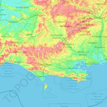
Name: Dorset topographic map, elevation, terrain.

Location: Dorset, England, United Kingdom (50.51272 -2.96159 51.08100 -1.68167)

Average elevation: 184 ft

Minimum elevation: -13 ft

Maximum elevation: 932 ft

Other topographic maps

Click on a map to view its topography, its elevation and its terrain.

London

United Kingdom > England > London

Average elevation: 138 ft

Pilgrims' Hatch

United Kingdom > England > Essex > Brentwood

Average elevation: 285 ft

Brighton

United Kingdom > England > Brighton and Hove

Average elevation: 210 ft

Cambridge

United Kingdom > England > Cambridge

The city, like most of the UK, has a maritime climate highly influenced by the Gulf Stream. Located in the driest region of Britain, Cambridge's rainfall averages around 570 mm (22.44 in) per year, around half the national average, with some years occasionally falling into the semi-arid (under 500 mm (19.69…

Average elevation: 59 ft

York

United Kingdom > England > York

Average elevation: 69 ft

Portsmouth

United Kingdom > England > Hampshire > Portsmouth

By road, Portsmouth lies 73.5 miles (118.3 km) from Central London, 49.5 miles (79.7 km) west of Brighton, and 22.3 miles (35.9 km) east of Southampton. Portsmouth is situated primarily on Portsea Island and is the United Kingdom's only island city, although parts of it have expanded onto the mainland. Gosport…

Average elevation: 92 ft

Telford

United Kingdom > England > Telford and Wrekin

Average elevation: 446 ft

Tonbridge

United Kingdom > England > Kent > Tonbridge and Malling

Average elevation: 171 ft

Lewisham

United Kingdom > England

Average elevation: 92 ft

Enfield

United Kingdom > England > Greater London

Average elevation: 128 ft

Walthamstow

United Kingdom > England

Average elevation: 69 ft

Basingstoke

United Kingdom > England > Hampshire > Basingstoke and Deane

Situated in a valley through the Hampshire Downs at an average elevation of 88 metres (289 ft) Basingstoke is a major interchange between Reading, Newbury, Andover, Winchester, and Alton, and lies on the natural trade route between the southwest of England and London. The area had been something of an…

Average elevation: 361 ft

Folkestone

United Kingdom > England > Folkestone

Average elevation: 151 ft

Reading

United Kingdom > England > Reading

Mary Russell Mitford lived in Reading for a number of years and then spent the rest of her life just outside the town at Three Mile Cross and Swallowfield. The fictional Belford Regis of her eponymous novel, first published in 1835, is largely based on Reading. Described with topographical accuracy, it is…

Average elevation: 184 ft

Swindon

United Kingdom > England > Swindon

Swindon has an oceanic climate (Cfb in the Köppen climate classification), like the vast majority of the British Isles, with cool winters and warm summers. The nearest official weather station is RAF Lyneham, about 10 miles (16 km) west southwest of Swindon town centre. The weather station's elevation is 145…

Average elevation: 354 ft

Plymouth

United Kingdom > England > Devon > Plymouth

The River Plym, which flows off Dartmoor to the north-east, forms a smaller estuary to the east of the city called Cattewater. Plymouth Sound is protected from the sea by the Plymouth Breakwater, in use since 1814. In the Sound is Drake's Island which is seen from Plymouth Hoe, a flat public area on top of…

Average elevation: 266 ft

Malvern

United Kingdom > England > Worcestershire > Malvern Hills

Malvern lies in the Lower Severn/Avon plain affording it a degree of shelter caused by virtue of its nestling in between the Cotswold hills to the east, the Welsh Hills and Mountains to the west, and Birmingham plateau to the north. Although as with all the British Isles it has a maritime climate, the local…

Average elevation: 312 ft

Blackburn

United Kingdom > England > Blackburn with Darwen

Average elevation: 515 ft

Allaleigh

United Kingdom > England > Devon > South Hams

Average elevation: 436 ft

Leeds

United Kingdom > England

Lying in the eastern foothills of the Pennines, there is a significant variation in elevation within the city's built-up area. The district ranges from 1,115 feet (340 m) in the far west on the slopes of Ilkley Moor to about 33 feet (10 m) where the rivers Aire and Wharfe cross the eastern boundary. Land rises…

Average elevation: 308 ft

Bexleyheath

United Kingdom > England

Average elevation: 95 ft

Louth

United Kingdom > England > Louth

Average elevation: 164 ft

Hemel Hempstead

United Kingdom > England > Hertfordshire > Dacorum

Average elevation: 427 ft

Pudsey

United Kingdom > England > Leeds

Average elevation: 420 ft

Keswick

United Kingdom > England > Keswick

Average elevation: 732 ft

Loughborough

United Kingdom > England > Leicestershire > Charnwood

Average elevation: 200 ft

Carlisle

United Kingdom > England > Cumberland

Average elevation: 102 ft

Peterborough

United Kingdom > England > Cambridgeshire

The local topography is flat, and in some places, the land lies below sea level, for example in parts of the Fens to the east and to the south of Peterborough. Human settlement in the area began before the Bronze Age, as can be seen at the Flag Fen archaeological site to the east of the current city centre,…

Average elevation: 56 ft

Nesscliffe

United Kingdom > England > Shropshire

Average elevation: 276 ft

Meopham Green

United Kingdom > England > Kent > Gravesham > Meopham

Average elevation: 427 ft

Taunton

United Kingdom > England > Somerset

Average elevation: 128 ft

Durham

United Kingdom > England > County Durham

Average elevation: 390 ft

Maker

United Kingdom > England > Cornwall > Kingsand

Average elevation: 98 ft

Chipping Barnet

United Kingdom > England > Greater London

Its name is very often abbreviated to just Barnet, which is also the name of the borough of which it forms a part; the town has been part of Greater London since 1965 after the abolition of Barnet Urban District then in Hertfordshire. Chipping Barnet is also the name of the Parliamentary constituency covering…

Average elevation: 312 ft

Denby Common

United Kingdom > England > Derbyshire > Amber Valley > Denby CP

Average elevation: 381 ft

Mellbreak

United Kingdom > England > Cumberland

Average elevation: 735 ft

Isles of Scilly

United Kingdom > England

Average elevation: 7 ft

Richmond Park

United Kingdom > England > Greater London

Average elevation: 85 ft

Bracknell

United Kingdom > England > Bracknell

Average elevation: 249 ft

Belper

United Kingdom > England > Derbyshire > Amber Valley > Belper

Average elevation: 400 ft

Wells

United Kingdom > England > Wells

Average elevation: 292 ft

St Albans

United Kingdom > England > Hertfordshire > St Albans

St Albans was an ancient borough created following the dissolution of the monastery in 1539. It consisted of the ancient parish of St Albans (also known as the Abbey parish) and parts of St Michael and St Peter. The municipal corporation was reformed by the Municipal Corporations Act 1835 and the boundary was…

Average elevation: 328 ft

Skiddaw

United Kingdom > England > Cumberland

Skiddaw is a mountain in the Lake District National Park in England. Its 931-metre (3,054 ft) summit is traditionally considered to be the fourth-highest peak but depending on what topographic prominence is thought to be significant is also variously ranked as the third- and the sixth-highest in England. It…

Average elevation: 2,067 ft

Quarrington Hill

United Kingdom > England > County Durham

Average elevation: 443 ft

Tottenham

United Kingdom > England

Tottenham's elevation is approximately 33 ft (10 m) above sea level.

Average elevation: 82 ft

The Green Park

United Kingdom > England > London

Average elevation: 72 ft

Parkwood Springs

United Kingdom > England > Sheffield

Average elevation: 308 ft

Old Dalby

United Kingdom > England > Leicestershire > Melton

Average elevation: 377 ft

Leatherhead

United Kingdom > England > Surrey > Mole Valley

Average elevation: 266 ft

Droitwich Spa

United Kingdom > England > Worcestershire > Wychavon

Average elevation: 161 ft

Mam Tor

United Kingdom > England > Derbyshire > High Peak

Average elevation: 1,138 ft

Scunthorpe

United Kingdom > England > North Lincolnshire

Average elevation: 92 ft

Harpenden

United Kingdom > England > Harpenden

Average elevation: 394 ft

Stourbridge

United Kingdom > England

Average elevation: 371 ft

Hebden Bridge

United Kingdom > England > Calderdale

Average elevation: 909 ft

Salisbury

United Kingdom > England > Salisbury

Bishop of Salisbury Hubert Walter was instrumental in the negotiations with Saladin during the Third Crusade, but he spent little time in his diocese prior to his elevation to archbishop of Canterbury. The brothers Herbert and Richard Poore succeeded him and began planning the relocation of the cathedral into…

Average elevation: 315 ft

Hull

United Kingdom > England > Kingston upon Hull

Kingston upon Hull is on the northern bank of the Humber Estuary. The city centre is west of the River Hull and close to the Humber. The city is built upon alluvial and glacial deposits which overlie chalk rocks but the underlying chalk has no influence on the topography. The land within the city is generally…

Average elevation: 69 ft

Poole Bay

United Kingdom > England

Average elevation: 0 ft

Bideford Bay

United Kingdom > England

Average elevation: 0 ft

Mount's Bay

United Kingdom > England

Average elevation: 0 ft

Falmouth Bay

United Kingdom > England

Average elevation: 0 ft

Lyme Bay

United Kingdom > England

Average elevation: 0 ft

Liverpool Bay

United Kingdom > England

Average elevation: 0 ft

Gayton

United Kingdom > England

Average elevation: 135 ft

Ebbsfleet

United Kingdom > England > Kent > Thanet

Average elevation: 13 ft

Farnworth

United Kingdom > England

Average elevation: 308 ft

Durham

United Kingdom > England > County Durham

Average elevation: 390 ft

Keston

United Kingdom > England

Average elevation: 341 ft

Harefield

United Kingdom > England

Average elevation: 217 ft

Larkhill

United Kingdom > England > Wiltshire

Average elevation: 364 ft

Eastham Village

United Kingdom > England

Average elevation: 79 ft

Greasby

United Kingdom > England

Average elevation: 105 ft

Middleton

United Kingdom > England

Average elevation: 371 ft

Atherton

United Kingdom > England

There were several ministers of note of Chowbent Chapel including James Wood, the "General" (1672–1759), who distinguished himself at the Battle of Preston in 1715. Thomas Walker Horsfield (1792–1837) was a historian and topographer. Joseph Nightingale (1775–1824), born in Chowbent, was a prolific…

Average elevation: 226 ft

Brighton

United Kingdom > England > Brighton and Hove

Average elevation: 92 ft

Whitefield

United Kingdom > England

Average elevation: 299 ft

Dinnington

United Kingdom > England

Average elevation: 299 ft

Brownhills

United Kingdom > England

Average elevation: 459 ft

Ashton-in-Makerfield

United Kingdom > England

Average elevation: 167 ft

Tyldesley

United Kingdom > England

At 53°30′59″N 2°28′0″W / 53.51639°N 2.46667°W / 53.51639; -2.46667 (53.5166°, −2.4668°), Tyldesley is situated eight miles (13 kilometres) east-southeast of Wigan and nine miles (14 kilometres) west-northwest of Manchester, and at the eastern end of the Metropolitan Borough of Wigan.…

Average elevation: 190 ft

Seahouses

United Kingdom > England > Northumberland

Average elevation: 20 ft

Dovercourt

United Kingdom > England > Essex > Tendring

Average elevation: 13 ft

Dronfield

United Kingdom > England > Dronfield

Average elevation: 522 ft

Saffron Walden

United Kingdom > England > Essex > Uttlesford

Average elevation: 289 ft

Huddersfield

United Kingdom > England > Kirklees

Average elevation: 476 ft

Haverhill

United Kingdom > England > Suffolk > West Suffolk

Average elevation: 305 ft

Portishead

United Kingdom > England > Portishead

Average elevation: 85 ft

Skipton

United Kingdom > England > Skipton

Average elevation: 659 ft

Gear up for your next adventure:

🧭Hiking Compass - Precision compass for reliable navigation in the wilderness
🔥Camping Stove - Portable stove for camping and backcountry cooking
🧷Carabiner Set - Durable clips for gear attachment
🧭Outdoor Navigation Book - Learn advanced navigation skills
🗺️NatGeo Topo Maps - High-quality waterproof printed topographic maps of US Parks

As an Amazon Associate, this site earns from qualifying purchases at no extra cost to you.