
Long Beach Township topographic map
Interactive map
Click on the map to display elevation.
About this map
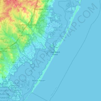
Name: Long Beach Township topographic map, elevation, terrain.
Location: Long Beach Township, Ocean County, New Jersey, United States (39.50822 -74.29612 39.77709 -74.11155)
Average elevation: 16 ft
Minimum elevation: -10 ft
Maximum elevation: 177 ft
Other topographic maps
Click on a map to view its topography, its elevation and its terrain.
Mystic Islands
United States > New Jersey > Ocean County > Little Egg Harbor Township
Mystic Islands, Little Egg Harbor Township, Ocean County, New Jersey, 08087, United States
Average elevation: 3 ft
Whiting
United States > New Jersey > Ocean County > Manchester Township
Whiting, Manchester Township, Ocean County, New Jersey, United States
Average elevation: 154 ft
Toms River
United States > New Jersey > Ocean County
Toms River, Ocean County, New Jersey, United States
Average elevation: 46 ft
Cranberry Hill
United States > New Jersey > Ocean County > Lacey Township > Forked River
Cranberry Hill, Forked River, Lacey Township, Ocean County, New Jersey, 08731, United States
Average elevation: 33 ft
Herbertsville
United States > New Jersey > Ocean County > Brick Township
Herbertsville, Brick Township, Ocean County, New Jersey, 08724, United States
Average elevation: 46 ft
Mystic Island
United States > New Jersey > Ocean County > Little Egg Harbor Township
Mystic Island, Little Egg Harbor Township, Ocean County, New Jersey, United States
Average elevation: 10 ft
Saint Vladimirs
United States > New Jersey > Ocean County > Jackson Township
Saint Vladimirs, Jackson Township, Ocean County, New Jersey, United States
Average elevation: 138 ft
New Egypt
United States > New Jersey > Ocean County > Plumsted Township
New Egypt, Plumsted Township, Ocean County, New Jersey, United States
Average elevation: 102 ft
Beachwood
United States > New Jersey > Ocean County
Beachwood, Ocean County, New Jersey, 08722, United States
Average elevation: 36 ft
Ocean Acres
United States > New Jersey > Ocean County > Stafford Township
Ocean Acres, Stafford Township, Ocean County, New Jersey, United States
Average elevation: 89 ft
Brick Township
United States > New Jersey > Ocean County
Brick Township, Ocean County, New Jersey, United States
Average elevation: 33 ft
Ortley Beach
United States > New Jersey > Ocean County > Toms River
Ortley Beach, Toms River, Ocean County, New Jersey, 08751, United States
Average elevation: 3 ft
Lakewood Township
United States > New Jersey > Ocean County
Lakewood Township, Ocean County, New Jersey, 08701, United States
Average elevation: 72 ft
Cedar Glen West
United States > New Jersey > Ocean County > Manchester Township > Cedar Glen West
Cedar Glen West, Manchester Township, Ocean County, New Jersey, United States
Average elevation: 79 ft
Cedar Glen Lakes
United States > New Jersey > Ocean County > Manchester Township > Cedar Glen Lakes
Cedar Glen Lakes, Manchester Township, Ocean County, New Jersey, United States
Average elevation: 154 ft
Holiday Heights
United States > New Jersey > Ocean County > Berkeley Township
Holiday Heights, Berkeley Township, Ocean County, New Jersey, United States
Average elevation: 52 ft
Little Egg Harbor Township
United States > New Jersey > Ocean County
Little Egg Harbor Township, Ocean County, New Jersey, 08087, United States
Average elevation: 36 ft
Jackson Township
United States > New Jersey > Ocean County
Jackson Township, Ocean County, New Jersey, 08527, United States
Average elevation: 118 ft
Barnegat
United States > New Jersey > Ocean County > Barnegat Township
Barnegat, Barnegat Township, Ocean County, New Jersey, United States
Average elevation: 46 ft
Little Egg Harbor
United States > New Jersey > Ocean County > Little Egg Harbor Township
Little Egg Harbor, Little Egg Harbor Township, Ocean County, New Jersey, United States
Average elevation: 7 ft
Barnegat Township
United States > New Jersey > Ocean County
Barnegat Township, Ocean County, New Jersey, 08005, United States
Average elevation: 46 ft
Tide Creek
United States > New Jersey > Ocean County > Toms River
Tide Creek, Toms River, Ocean County, New Jersey, 08723, United States
Average elevation: 3 ft
Long Beach Island
United States > New Jersey > Ocean County > Long Beach Township
Long Beach Island, Long Beach Township, Ocean County, New Jersey, United States
Average elevation: 13 ft
South Toms River
United States > New Jersey > Ocean County
South Toms River, Ocean County, New Jersey, United States
Average elevation: 33 ft
Manchester Township
United States > New Jersey > Ocean County
Manchester Township, Ocean County, New Jersey, United States
Average elevation: 112 ft
Stafford Township
United States > New Jersey > Ocean County
Stafford Township, Ocean County, New Jersey, 08050, United States
Average elevation: 52 ft
Forked River Beach
United States > New Jersey > Ocean County > Lacey Township
Forked River Beach, Lacey Township, Ocean County, New Jersey, 08731, United States
Average elevation: 7 ft
Bay Head
United States > New Jersey > Ocean County
Bay Head, Ocean County, New Jersey, United States
Average elevation: 7 ft
Keswick Grove
United States > New Jersey > Ocean County > Manchester Township
Keswick Grove, Manchester Township, Ocean County, New Jersey, United States
Average elevation: 115 ft
Toms River
United States > New Jersey > Ocean County > Toms River
Toms River, Ocean County, New Jersey, 08722, United States
Average elevation: 26 ft
Tuckerton
United States > New Jersey > Ocean County
Tuckerton, Ocean County, New Jersey, United States
Average elevation: 10 ft
Ship Bottom
United States > New Jersey > Ocean County
Ship Bottom, Ocean County, New Jersey, United States
Average elevation: 3 ft
Island Beach State Park
United States > New Jersey > Ocean County > Berkeley Township
Island Beach State Park, Berkeley Township, Ocean County, New Jersey, United States
Average elevation: 3 ft
Jacques Cousteau National Estuarine Research Reserve
United States > New Jersey > Ocean County
Jacques Cousteau National Estuarine Research Reserve, Ocean County, New Jersey, United States
Average elevation: 16 ft
Arrowhead Village
United States > New Jersey > Ocean County > Brick Township
Arrowhead Village, Brick Township, Ocean County, New Jersey, 08724, United States
Average elevation: 20 ft
Lavallette
United States > New Jersey > Ocean County
Lavallette, Ocean County, New Jersey, United States
Average elevation: 3 ft
Plumsted Township
United States > New Jersey > Ocean County
Plumsted Township, Ocean County, New Jersey, 08533, United States
Average elevation: 121 ft
Mantoloking Estates
United States > New Jersey > Ocean County > Brick Township
Mantoloking Estates, Brick Township, Ocean County, New Jersey, 08739, United States
Average elevation: 0 ft
Lakewood
United States > New Jersey > Ocean County > Lakewood
Lakewood, Ocean County, New Jersey, 08701, United States
Average elevation: 82 ft
Berkeley Township
United States > New Jersey > Ocean County
Berkeley Township, Ocean County, New Jersey, 09721, United States
Average elevation: 33 ft
Lacey Township
United States > New Jersey > Ocean County > Lacey Township
Lacey Township, Ocean County, New Jersey, United States
Average elevation: 85 ft
Point Pleasant Beach
United States > New Jersey > Ocean County
Point Pleasant Beach, Ocean County, New Jersey, United States
Average elevation: 10 ft
Deer Lake Park
United States > New Jersey > Ocean County > Stafford Township
Deer Lake Park, Stafford Township, Ocean County, New Jersey, 08050, United States
Average elevation: 43 ft
Lakehurst
United States > New Jersey > Ocean County
Lakehurst, Ocean County, New Jersey, United States
Average elevation: 69 ft
Barnegat Beach
United States > New Jersey > Ocean County > Waretown
Barnegat Beach, Waretown, Ocean Township, Ocean County, New Jersey, 08758, United States
Average elevation: 13 ft
Mantoloking
United States > New Jersey > Ocean County
Mantoloking, Ocean County, New Jersey, United States
Average elevation: 0 ft
Breton Woods
United States > New Jersey > Ocean County > Brick Township
Breton Woods, Brick Township, Ocean County, New Jersey, 08723, United States
Average elevation: 10 ft
Chadwick
United States > New Jersey > Ocean County > Toms River
Chadwick, Toms River, Ocean County, New Jersey, 07835, United States
Average elevation: 0 ft
Surf City
United States > New Jersey > Ocean County > Surf City
Surf City, Ocean County, New Jersey, United States
Average elevation: 3 ft
West Tuckerton Landing
United States > New Jersey > Ocean County > Tuckerton > West Tuckerton Landing
West Tuckerton Landing, Tuckerton, Ocean County, New Jersey, 08087, United States
Average elevation: 16 ft