Geolocate

Vossavangen topographic map

Click on the map to display elevation.

About this map

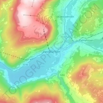
Name: Vossavangen topographic map, elevation, terrain.

Location: Vossavangen, Voss, Vestland, 5704, Norway (60.58869 6.37474 60.66869 6.45474)

Average elevation: 1,155 ft

Minimum elevation: 128 ft

Maximum elevation: 3,028 ft

Other topographic maps

Click on a map to view its topography, its elevation and its terrain.

Tysnes

Norway > Vestland

Average elevation: 318 ft

Lærdal

Norway > Vestland

Average elevation: 3,789 ft

Voss

Norway > Vestland

Average elevation: 2,510 ft

Austevoll

Norway > Vestland

Average elevation: 20 ft

Sveio

Norway > Vestland

Average elevation: 187 ft

Kvam herad

Norway > Vestland

Average elevation: 1,677 ft

Vik

Norway > Vestland

Average elevation: 2,425 ft

Bjørnafjorden

Norway > Vestland

Average elevation: 30 ft

Høyanger

Norway > Vestland

Average elevation: 1,732 ft

Sogndal

Norway > Vestland

Average elevation: 2,379 ft

Gear up for your next adventure:

🛡️Insect Repellent - Protection against bugs during outdoor activities
🧭Pro Hiking Compasses - High-accuracy liquid-filled compasses for topographic orientation
🔌USB Car Charger - Car charger for on‑the‑go power needs
🛌Ultralight Sleeping Bags - Compact down bags for cold nights in the wilderness
🖼️Topo Map Wall Art - Decorative topographic prints of famous peaks and regions

As an Amazon Associate, this site earns from qualifying purchases at no extra cost to you.