Geolocate

Tysnes topographic map

Click on the map to display elevation.

About this map

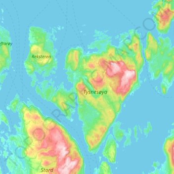
Name: Tysnes topographic map, elevation, terrain.

Location: Tysnes, Vestland, Norway (59.85823 5.32212 60.12440 5.76973)

Average elevation: 318 ft

Minimum elevation: -13 ft

Maximum elevation: 2,418 ft

Other topographic maps

Click on a map to view its topography, its elevation and its terrain.

Flåm

Norway > Vestland

Average elevation: 1,509 ft

Sogndal

Norway > Vestland

Average elevation: 1,033 ft

Storen

Norway > Vestland

Average elevation: 5,722 ft

Høgalmane

Norway > Vestland

Average elevation: 1,772 ft

Rognaldsvåg

Norway > Vestland

Average elevation: 46 ft

Svelgen

Norway > Vestland

Average elevation: 705 ft

Bjørnafjorden

Norway > Vestland

Average elevation: 30 ft

Undredal

Norway > Vestland

Average elevation: 1,335 ft

Vossavangen

Norway > Vestland

Average elevation: 1,155 ft

Florø

Norway > Vestland

Average elevation: 46 ft

Vinjane

Norway > Vestland > Aurlandsvangen

Average elevation: 758 ft

Flåm

Norway > Vestland > Flåm

Average elevation: 1,601 ft

Borgund

Norway > Vestland > Borgund

Average elevation: 2,539 ft

Heidi

Norway > Vestland > Lonevåg

Average elevation: 344 ft

Prest

Norway > Vestland

Average elevation: 3,996 ft

Preikestolen

Norway > Vestland

Average elevation: 860 ft

Olden

Norway > Vestland > Olden

Average elevation: 1,289 ft

Ortnevik

Norway > Vestland

Average elevation: 735 ft

Maurstad

Norway > Vestland

Average elevation: 427 ft

Gear up for your next adventure:

🧭Orienteering Set - Complete compass and map reading kit
🎁Geography Themed Gifts - Unique gift ideas for map lovers and geography enthusiasts
🧭Hiking Compass - Precision compass for reliable navigation in the wilderness
📻Weather Alert Radios - Stay informed of storm risks while off-the-grid
☀️Outdoor Sunscreen - High protection sunscreen for outdoor activities

As an Amazon Associate, this site earns from qualifying purchases at no extra cost to you.