Geolocate

Lærdal topographic map

Click on the map to display elevation.

About this map

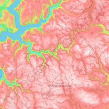
Name: Lærdal topographic map, elevation, terrain.

Location: Lærdal, Vestland, Norway (60.84171 6.99881 61.23550 8.28266)

Average elevation: 3,789 ft

Minimum elevation: 0 ft

Maximum elevation: 6,286 ft

Other topographic maps

Click on a map to view its topography, its elevation and its terrain.

Vossavangen

Norway > Vestland

Average elevation: 1,155 ft

Svelgen

Norway > Vestland

Average elevation: 705 ft

Sogndal

Norway > Vestland

Average elevation: 1,033 ft

Flåm

Norway > Vestland

Average elevation: 1,509 ft

Storen

Norway > Vestland

Average elevation: 5,722 ft

Undredal

Norway > Vestland

Average elevation: 1,335 ft

Høgalmane

Norway > Vestland

Average elevation: 1,772 ft

Vinjane

Norway > Vestland > Aurlandsvangen

Average elevation: 758 ft

Rognaldsvåg

Norway > Vestland

Average elevation: 46 ft

Bjørnafjorden

Norway > Vestland

Average elevation: 30 ft

Florø

Norway > Vestland

Average elevation: 46 ft

Flåm

Norway > Vestland > Flåm

Average elevation: 1,601 ft

Borgund

Norway > Vestland > Borgund

Average elevation: 2,539 ft

Preikestolen

Norway > Vestland

Average elevation: 860 ft

Maurstad

Norway > Vestland

Average elevation: 427 ft

Olden

Norway > Vestland > Olden

Average elevation: 1,289 ft

Heidi

Norway > Vestland > Lonevåg

Average elevation: 344 ft

Prest

Norway > Vestland

Average elevation: 3,996 ft

Ortnevik

Norway > Vestland

Average elevation: 735 ft

Gear up for your next adventure:

🌎3D Topographic Globes - Raised relief globes for a tactile understanding of geography
🥇GPS Hiking Watch - Multi‑sport GPS watch with navigation and trail tracking
🥤Water Filter Bottle - All‑in‑one filter bottle for safe hydration
🥄Camping Utensil Set - Lightweight utensils for outdoor meals
🔥Camping Stove - Portable stove for camping and backcountry cooking

As an Amazon Associate, this site earns from qualifying purchases at no extra cost to you.