
Make a donation
Gear up for your next adventure:
As an Amazon Associate, this site earns from qualifying purchases at no extra cost to you.
Kigali City topographic map
Click on the map to display elevation.
Make a donation
Gear up for your next adventure:
As an Amazon Associate, this site earns from qualifying purchases at no extra cost to you.
Kigali City
Kigali is located in the centre of Rwanda, at 1°57′S 30°4′E. Like the rest of Rwanda it uses Central Africa Time, and is two hours ahead of Coordinated Universal Time (UTC+02:00) throughout the year. The city is coterminous with the province of Kigali, one of the five provinces of Rwanda introduced in 2006 as part of a restructuring of local government in the country. The city has boundaries with the Northern, Eastern and Southern provinces. It is divided into three administrative districts—Nyarugenge in the south west, Kicukiro in the south east, and Gasabo, which occupies the northern half of the city's territory. The built-up urban area covers about 70 per cent of the municipal boundaries. Kigali lies in a region of rolling hills, with a series of valleys and ridges joined by steep slopes. It is situated between Mount Kigali and Mount Jali, both of which have elevations of more than 1,800 m (5,906 ft) above sea level, while the lowest areas of the city have an altitude of 1,300 m (4,265 ft). Geologically, Kigali is in a granitic and metasedimentary region, with lateritic soils on the hills and alluvial soils in the valleys.
Make a donation
Gear up for your next adventure:
As an Amazon Associate, this site earns from qualifying purchases at no extra cost to you.
About this map
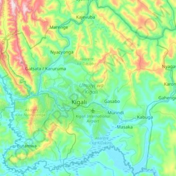
Name: Kigali City topographic map, elevation, terrain.
Location: Kigali City, Rwanda (-2.07982 29.97953 -1.77958 30.27987)
Average elevation: 5,007 ft
Minimum elevation: 4,370 ft
Maximum elevation: 7,100 ft
Make a donation
Gear up for your next adventure:
As an Amazon Associate, this site earns from qualifying purchases at no extra cost to you.
Other topographic maps
Click on a map to view its topography, its elevation and its terrain.
Kigali
Rwanda > Kigali City > Nyarugenge District
Kigali is located in the centre of Rwanda, at 1°57′S 30°4′E. Like the rest of Rwanda it uses Central Africa Time, and is two hours ahead of Coordinated Universal Time (UTC+02:00) throughout the year. The city is coterminous with the province of Kigali, one of the five provinces of Rwanda introduced in…
Average elevation: 5,020 ft
Make a donation
Gear up for your next adventure:
As an Amazon Associate, this site earns from qualifying purchases at no extra cost to you.
Make a donation
Gear up for your next adventure:
As an Amazon Associate, this site earns from qualifying purchases at no extra cost to you.
Make a donation
Gear up for your next adventure:
As an Amazon Associate, this site earns from qualifying purchases at no extra cost to you.
Make a donation
Gear up for your next adventure:
As an Amazon Associate, this site earns from qualifying purchases at no extra cost to you.
Make a donation
Gear up for your next adventure:
As an Amazon Associate, this site earns from qualifying purchases at no extra cost to you.
Kabgayi
Rwanda > Southern Province > Muhanga District > Nyamabuye
Kabgayi lies in the middle of Rwanda's central plateau at an elevation of about 6,000 feet (1,800 m) above sea level. Located in Kamazuru Village of Gahogo Cell in Nyamabuye Sector, it is a 5 minutes’ drive from Muhanga City. The community is just south of Gitarama, the second-largest city in Rwanda, and…
Average elevation: 6,020 ft
Make a donation
Gear up for your next adventure:
As an Amazon Associate, this site earns from qualifying purchases at no extra cost to you.
Make a donation
Gear up for your next adventure:
As an Amazon Associate, this site earns from qualifying purchases at no extra cost to you.
Make a donation
Gear up for your next adventure:
As an Amazon Associate, this site earns from qualifying purchases at no extra cost to you.
Make a donation
Gear up for your next adventure:
As an Amazon Associate, this site earns from qualifying purchases at no extra cost to you.