
Make a donation
Gear up for your next adventure:
As an Amazon Associate, this site earns from qualifying purchases at no extra cost to you.
Montrock topographic map
Click on the map to display elevation.
Make a donation
Gear up for your next adventure:
As an Amazon Associate, this site earns from qualifying purchases at no extra cost to you.
About this map
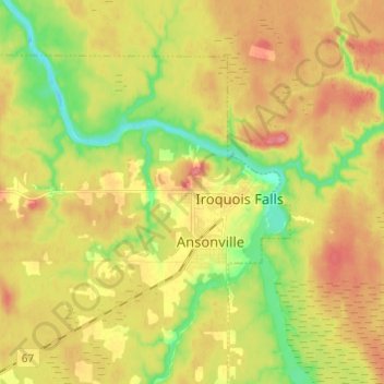
Name: Montrock topographic map, elevation, terrain.
Average elevation: 896 ft
Minimum elevation: 764 ft
Maximum elevation: 1,014 ft
Make a donation
Gear up for your next adventure:
As an Amazon Associate, this site earns from qualifying purchases at no extra cost to you.
Other topographic maps
Click on a map to view its topography, its elevation and its terrain.
Wadsworth Lake
Canada > Ontario > Cochrane District > Unorganized North Cochrane
Average elevation: 1,060 ft
Cochrane
Canada > Ontario > Cochrane District
Until 1977, Timmins was used as the source for all weather readings attributed to Cochrane except for exceptional extremes, due to the overall similar climate due to proximity and topography. However, in December 1977, Cochrane temperature readings began to be taken from downtown after a noticeable difference…
Average elevation: 860 ft
Make a donation
Gear up for your next adventure:
As an Amazon Associate, this site earns from qualifying purchases at no extra cost to you.
Painkiller Lake
Canada > Ontario > Cochrane District > Black River-Matheson Township
Average elevation: 991 ft
Borgford Lake
Canada > Ontario > Cochrane District > Black River-Matheson Township
Average elevation: 1,135 ft
Kapuskasing
Canada > Ontario > Cochrane District
Kapuskasing lies in the heart of the Great Clay Belt. The topography of the region is very flat, dotted with numerous small lakes and muskeg bogs. Also in the heart of Canada's boreal forest, the region is drained by rivers running north to James Bay. The district is heavily forested, mostly by thick stands of…
Average elevation: 745 ft
Make a donation
Gear up for your next adventure:
As an Amazon Associate, this site earns from qualifying purchases at no extra cost to you.
Arrow Lake
Canada > Ontario > Cochrane District > Unorganized South West Cochrane
Average elevation: 974 ft
Make a donation
Gear up for your next adventure:
As an Amazon Associate, this site earns from qualifying purchases at no extra cost to you.
Watersnake Lake
Canada > Ontario > Cochrane District > Fauquier-Strickland Township
Average elevation: 764 ft
Make a donation
Gear up for your next adventure:
As an Amazon Associate, this site earns from qualifying purchases at no extra cost to you.
Snare Lake
Canada > Ontario > Cochrane District > Unorganized North Cochrane
Average elevation: 984 ft
Ptarmigan Lake
Canada > Ontario > Cochrane District > Unorganized North Cochrane
Average elevation: 738 ft
Make a donation
Gear up for your next adventure:
As an Amazon Associate, this site earns from qualifying purchases at no extra cost to you.
Lady Lake
Canada > Ontario > Cochrane District > Unorganized North Cochrane
Average elevation: 1,017 ft
Make a donation
Gear up for your next adventure:
As an Amazon Associate, this site earns from qualifying purchases at no extra cost to you.
Joseph Lake
Canada > Ontario > Cochrane District > Unorganized North Cochrane
Average elevation: 889 ft
Moose Factory Island
Canada > Ontario > Cochrane District > Unorganized North Cochrane
Average elevation: 13 ft
Make a donation
Gear up for your next adventure:
As an Amazon Associate, this site earns from qualifying purchases at no extra cost to you.
Ghost River
Canada > Ontario > Cochrane District > Unorganized North Cochrane
Average elevation: 942 ft
Make a donation
Gear up for your next adventure:
As an Amazon Associate, this site earns from qualifying purchases at no extra cost to you.
Kabinakagami River
Canada > Ontario > Cochrane District > Unorganized North Cochrane
Average elevation: 820 ft
Make a donation
Gear up for your next adventure:
As an Amazon Associate, this site earns from qualifying purchases at no extra cost to you.
Teal Creek
Canada > Ontario > Cochrane District > Unorganized North Cochrane
Average elevation: 666 ft
Ghost Lake;Pearce Creek
Canada > Ontario > Cochrane District > Unorganized North Cochrane
Average elevation: 699 ft
Unorganized South West Cochrane
Canada > Ontario > Cochrane District > Unorganized South West Cochrane
Average elevation: 1,024 ft
Watabeag River
Canada > Ontario > Cochrane District > Black River-Matheson Township
Average elevation: 856 ft
Make a donation
Gear up for your next adventure:
As an Amazon Associate, this site earns from qualifying purchases at no extra cost to you.
Sheen Lake
Canada > Ontario > Cochrane District > Unorganized North Cochrane
Average elevation: 925 ft
Moose Factory Island
Canada > Ontario > Cochrane District > Unorganized North Cochrane
Average elevation: 13 ft
Kapuskasing
Canada > Ontario > Cochrane District
Kapuskasing lies in the heart of the Great Clay Belt. The topography of the region is very flat, dotted with numerous small lakes and muskeg bogs. Also in the heart of Canada's boreal forest, the region is drained by rivers running north to James Bay. The district is heavily forested, mostly by thick stands of…
Average elevation: 745 ft
Make a donation
Gear up for your next adventure:
As an Amazon Associate, this site earns from qualifying purchases at no extra cost to you.
Big Cedar Creek
Canada > Ontario > Cochrane District > Unorganized North Cochrane
Average elevation: 161 ft
Make a donation
Gear up for your next adventure:
As an Amazon Associate, this site earns from qualifying purchases at no extra cost to you.
Make a donation
Gear up for your next adventure:
As an Amazon Associate, this site earns from qualifying purchases at no extra cost to you.
Make a donation
Gear up for your next adventure:
As an Amazon Associate, this site earns from qualifying purchases at no extra cost to you.