
Moosonee topographic map
Click on the map to display elevation.
About this map
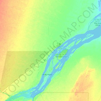
Name: Moosonee topographic map, elevation, terrain.
Average elevation: 43 ft
Minimum elevation: -16 ft
Maximum elevation: 102 ft
Other topographic maps
Click on a map to view its topography, its elevation and its terrain.
Painkiller Lake
Canada > Ontario > Cochrane District > Black River-Matheson Township
Average elevation: 991 ft
Borgford Lake
Canada > Ontario > Cochrane District > Black River-Matheson Township
Average elevation: 1,135 ft
Arrow Lake
Canada > Ontario > Cochrane District > Unorganized South West Cochrane
Average elevation: 974 ft
Watersnake Lake
Canada > Ontario > Cochrane District > Fauquier-Strickland Township
Average elevation: 764 ft
Kabinakagami River
Canada > Ontario > Cochrane District > Unorganized North Cochrane
Average elevation: 820 ft
Snare Lake
Canada > Ontario > Cochrane District > Unorganized North Cochrane
Average elevation: 984 ft
Watabeag River
Canada > Ontario > Cochrane District > Black River-Matheson Township
Average elevation: 856 ft
Ptarmigan Lake
Canada > Ontario > Cochrane District > Unorganized North Cochrane
Average elevation: 738 ft
Lady Lake
Canada > Ontario > Cochrane District > Unorganized North Cochrane
Average elevation: 1,017 ft
Joseph Lake
Canada > Ontario > Cochrane District > Unorganized North Cochrane
Average elevation: 889 ft
Moose Factory Island
Canada > Ontario > Cochrane District > Unorganized North Cochrane
Average elevation: 13 ft
Wadsworth Lake
Canada > Ontario > Cochrane District > Unorganized North Cochrane
Average elevation: 1,060 ft
Ghost River
Canada > Ontario > Cochrane District > Unorganized North Cochrane
Average elevation: 942 ft
Moonbeam
Canada > Ontario > Cochrane District > Moonbeam Township > Moonbeam
Average elevation: 781 ft
Teal Creek
Canada > Ontario > Cochrane District > Unorganized North Cochrane
Average elevation: 666 ft
Nipin Lake
Canada > Ontario > Cochrane District > Unorganized North Cochrane
Average elevation: 863 ft
Sheen Lake
Canada > Ontario > Cochrane District > Unorganized North Cochrane
Average elevation: 925 ft
Moose Factory Island
Canada > Ontario > Cochrane District > Unorganized North Cochrane
Average elevation: 13 ft
Big Cedar Creek
Canada > Ontario > Cochrane District > Unorganized North Cochrane
Average elevation: 161 ft
The Canyon
Canada > Ontario > Cochrane District > Unorganized North Cochrane
Average elevation: 827 ft