Geolocate

Middle River topographic map

Click on the map to display elevation.

About this map

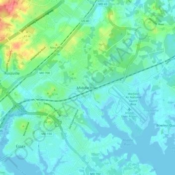
Name: Middle River topographic map, elevation, terrain.

Location: Middle River, Baltimore County, Maryland, 21220, United States (39.29427 -76.47941 39.37427 -76.39941)

Average elevation: 46 ft

Minimum elevation: -33 ft

Maximum elevation: 246 ft

Baltimore County trails, hiking, mountain biking, running and outdoor activities

Other topographic maps

Click on a map to view its topography, its elevation and its terrain.

Towson

United States > Maryland > Baltimore County > Towson

Average elevation: 374 ft

Lochearn

United States > Maryland > Baltimore County > Lochearn

Average elevation: 443 ft

Hampton

United States > Maryland > Baltimore County > Hampton

Average elevation: 354 ft

Woodlawn

United States > Maryland > Baltimore County > Woodlawn

Average elevation: 417 ft

Parkville

United States > Maryland > Baltimore County > Parkville

Average elevation: 364 ft

Rosedale

United States > Maryland > Baltimore County > Rosedale

Average elevation: 92 ft

Woodlawn

United States > Maryland > Baltimore County > Woodlawn

Average elevation: 417 ft

Lake Roland

United States > Maryland > Baltimore County > Towson > Ruxton

Average elevation: 325 ft

Essex

United States > Maryland > Baltimore County > Essex

Average elevation: 20 ft

Lansdowne

United States > Maryland > Baltimore County > Lansdowne

Average elevation: 79 ft

Lochearn

United States > Maryland > Baltimore County > Lochearn

Average elevation: 443 ft

Perry Hall

United States > Maryland > Baltimore County > Perry Hall

Average elevation: 240 ft

Lutherville

United States > Maryland > Baltimore County > Riderwood

Average elevation: 381 ft

Overlea

United States > Maryland > Baltimore County > Overlea

Average elevation: 207 ft

Woodlawn

United States > Maryland > Baltimore County > Woodlawn

Average elevation: 417 ft

Kingsville

United States > Maryland > Baltimore County > Kingsville

Average elevation: 279 ft

West Wind

United States > Maryland > Baltimore County

Average elevation: 482 ft

Parkville

United States > Maryland > Baltimore County > Parkville

Average elevation: 364 ft

Lutherville

United States > Maryland > Baltimore County > Riderwood

Average elevation: 381 ft

Lochearn

United States > Maryland > Baltimore County > Lochearn

Average elevation: 443 ft

Perry Hall

United States > Maryland > Baltimore County > Perry Hall

Average elevation: 240 ft

Mays Chapel

United States > Maryland > Baltimore County > Riderwood

Average elevation: 423 ft

Parkville

United States > Maryland > Baltimore County > Parkville

Average elevation: 364 ft

Rossville

United States > Maryland > Baltimore County > Rossville

Average elevation: 108 ft

Wetherfield

United States > Maryland > Baltimore County

Average elevation: 315 ft

Hampton

United States > Maryland > Baltimore County > Hampton

Average elevation: 354 ft

Lutherville

United States > Maryland > Baltimore County > Riderwood

Average elevation: 381 ft

Rosedale

United States > Maryland > Baltimore County > Rosedale

Average elevation: 92 ft

Timonium

United States > Maryland > Baltimore County > Timonium

Average elevation: 371 ft

Pikesville

United States > Maryland > Baltimore County > Pikesville

Average elevation: 443 ft

Lansdowne

United States > Maryland > Baltimore County > Lansdowne

Average elevation: 79 ft

Pikesville

United States > Maryland > Baltimore County > Pikesville

Average elevation: 443 ft

Parkville

United States > Maryland > Baltimore County > Parkville

Average elevation: 364 ft

Towson

United States > Maryland > Baltimore County > Towson

Average elevation: 374 ft

Towson

United States > Maryland > Baltimore County > Towson

Average elevation: 374 ft

Arbutus

United States > Maryland > Baltimore County > Relay

Average elevation: 138 ft

Essex

United States > Maryland > Baltimore County > Essex

Average elevation: 20 ft

Carney

United States > Maryland > Baltimore County > Oakleigh

Average elevation: 338 ft

Gear up for your next adventure:

🌲Outdoor Survival Books - Best books on survival skills
🔭Compact Binoculars - HD vision for scouting terrain and identifying distant landmarks
🪶Camp Gear Gift Set - Perfect gift bundle for outdoor fans
🦶Carbon Trekking Poles - Reduce knee impact on steep descents with ultra-light poles
🗺️Topographic Maps - Detailed topo maps for hiking, exploring and outdoor navigation

As an Amazon Associate, this site earns from qualifying purchases at no extra cost to you.