Geolocate

Stirling topographic map

Click on the map to display elevation.

About this map

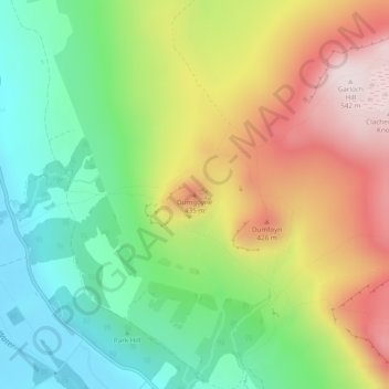
Name: Stirling topographic map, elevation, terrain.

Location: Stirling, Scotland, G63 9AJ, United Kingdom, Dumgoyne (56.01554 -4.34124 56.01564 -4.34114)

Average elevation: 797 ft

Minimum elevation: 75 ft

Maximum elevation: 1,781 ft

Other topographic maps

Click on a map to view its topography, its elevation and its terrain.

Out Skerries

United Kingdom > Scotland > Shetland

Being so close to Norway, the islands were of strategic importance in World War II and were a regular landfall for Norwegian boats carrying escapees from the Nazi occupation. The local coastguard were responsible for the refugees and at one point during the war were issued with a tommy gun, although initially…

Average elevation: 3 ft

Tarbert

United Kingdom > Scotland > Argyll and Bute

Average elevation: 226 ft

Eilean Donan

United Kingdom > Scotland > Highland > Dornie > Totaig

In 1689, King James VII of the House of Stuart was declared to have to forfeit the throne, and the crown was offered to William of Orange, in the so-called "Glorious Revolution". The revolution also established Presbyterianism in Scotland, although the Highlands generally remained Roman Catholic and loyal to…

Average elevation: 269 ft

Torsa

United Kingdom > Scotland > Argyll and Bute > Cuan > Silver Moon

Average elevation: 39 ft

Loch Katrine

United Kingdom > Scotland > Stirling

Average elevation: 1,145 ft

Easdale

United Kingdom > Scotland > Argyll and Bute > Easdale

Average elevation: 26 ft

Island

United Kingdom > Scotland > Shetland > Mid Yell

Average elevation: 66 ft

Texa

United Kingdom > Scotland > Argyll and Bute

Average elevation: 3 ft

Ailsa Craig

United Kingdom > Scotland

In a small glen above Ailsa Castle, a small freshwater body known as the Garry Loch is located at an altitude of 247 m (810 ft), with a depth of at least 17 feet.

Average elevation: 46 ft

Forgue

United Kingdom > Scotland > Aberdeenshire

Average elevation: 371 ft

Bute

United Kingdom > Scotland > Argyll and Bute > Townhead

Average elevation: 135 ft

Rosyth

United Kingdom > Scotland > Fife

Average elevation: 75 ft

Scapa Bay

United Kingdom > Scotland > Orkney Islands > Kirkwall

Average elevation: 66 ft

Hoy

United Kingdom > Scotland > Orkney Islands > Rackwick

Average elevation: 190 ft

Scarba

United Kingdom > Scotland > Argyll and Bute

Average elevation: 299 ft

Lamb Holm

United Kingdom > Scotland > Orkney Islands

Average elevation: 10 ft

Hebrides

United Kingdom > Scotland

Average elevation: 233 ft

Àird

United Kingdom > Scotland > Western Isles

There is a dense cluster of lochs across almost the entire island, and almost all of the island is below 20 metres (70 feet) in elevation.

Average elevation: 16 ft

Western Isles

United Kingdom > Scotland

Average elevation: 16 ft

Western Isles

United Kingdom > Scotland

Average elevation: 138 ft

Sea of the Hebrides

United Kingdom > Scotland

Average elevation: 59 ft

Auchtertool

United Kingdom > Scotland > Fife

Average elevation: 371 ft

Lerwick

United Kingdom > Scotland > Shetland

Lerwick has transitioned from a subpolar oceanic climate (Cfc) to a maritime climate (Cfb) with cool to cold temperatures all year long. The lack of trees reflects the latter type. This is particularly pronounced by virtue of Lerwick being on the coast of an island, so even extreme temperature records are…

Average elevation: 112 ft

Fair Isle

United Kingdom > Scotland > Shetland > Stonybreck

Average elevation: 72 ft

Mingulay

United Kingdom > Scotland

Average elevation: 141 ft

Thurso

United Kingdom > Scotland > Highland

Average elevation: 82 ft

Shetland

United Kingdom > Scotland > Shetland

Average elevation: 36 ft

Dubh Artach

United Kingdom > Scotland > Dubh Artach

Average elevation: 0 ft

Applecross

United Kingdom > Scotland > Highland

Average elevation: 489 ft

East Dunbartonshire

United Kingdom > Scotland

Average elevation: 528 ft

Cairnhill Woods

United Kingdom > Scotland > Glasgow City > Glasgow

Average elevation: 128 ft

Loch Toll an Lochain

United Kingdom > Scotland > Highland

Average elevation: 2,090 ft

Coll

United Kingdom > Scotland > Argyll and Bute > Arinagour

Average elevation: 23 ft

Vaila

United Kingdom > Scotland

Average elevation: 39 ft

The Taing

United Kingdom > Scotland > Shetland > Saxa Vord > Norwick

Average elevation: 167 ft

Ardrishaig

United Kingdom > Scotland > Argyll and Bute

Average elevation: 217 ft

South Lanarkshire

United Kingdom > Scotland

Average elevation: 948 ft

East Ayrshire

United Kingdom > Scotland

East Ayrshire is located on the west coat of Scotland, sharing borders with the following neighbouring council areas; North Ayrshire, South Ayrshire, Dumfries and Galloway, East Renfrewshire and South Lanarkshire. Blackcraig Hill reaches an elevation of 2,298 feet (700 metres), the highest peak in East…

Average elevation: 738 ft

Inverclyde

United Kingdom > Scotland

Average elevation: 463 ft

North Lanarkshire

United Kingdom > Scotland

Average elevation: 489 ft

East Renfrewshire

United Kingdom > Scotland

Average elevation: 535 ft

Clackmannanshire

United Kingdom > Scotland

Average elevation: 574 ft

Vatersay

United Kingdom > Scotland > Western Isles > Vatersay

Average elevation: 62 ft

Gear up for your next adventure:

📖Nature Tracking Books - Learn to track wildlife and terrain
Camping Coffee Makers - Enjoy premium coffee at the summit or campsite
🧦Hiking Socks - Comfortable socks to prevent blisters on long hikes
🖼️Topo Map Wall Art - Decorative topographic prints of famous peaks and regions
💧Water Purification System - Clean water on the trail with reliable purifiers

As an Amazon Associate, this site earns from qualifying purchases at no extra cost to you.