
Make a donation
Gear up for your next adventure:
As an Amazon Associate, this site earns from qualifying purchases at no extra cost to you.
Glenn County topographic map
Click on the map to display elevation.
Make a donation
Gear up for your next adventure:
As an Amazon Associate, this site earns from qualifying purchases at no extra cost to you.
About this map
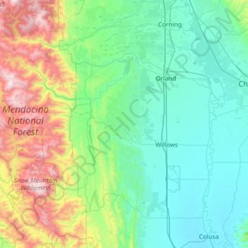
Name: Glenn County topographic map, elevation, terrain.
Location: Glenn County, California, United States (39.38298 -122.93825 39.80062 -121.85665)
Average elevation: 1,421 ft
Minimum elevation: 39 ft
Maximum elevation: 7,313 ft
California trails, hiking, mountain biking, running and outdoor activities
Make a donation
Gear up for your next adventure:
As an Amazon Associate, this site earns from qualifying purchases at no extra cost to you.
Other topographic maps
Click on a map to view its topography, its elevation and its terrain.
San Francisco Bay Area
United States > California > San Francisco
The San Francisco Bay Area is characterized by a diverse and dynamic topography shaped by geological processes over millions of years. This region features a combination of coastal plains, steep hills, and rugged mountains, all influenced by the tectonic activity associated with the nearby San Andreas Fault…
Average elevation: 371 ft
San Diego
United States > California > San Diego County > San Diego
The climate in San Diego, like most of Southern California, often varies significantly over short geographical distances, resulting in microclimates. In San Diego, this is mostly because of the city's topography (the Bay, and the numerous hills, mountains, and canyons). Frequently, particularly during the "May…
Average elevation: 187 ft
Make a donation
Gear up for your next adventure:
As an Amazon Associate, this site earns from qualifying purchases at no extra cost to you.
Oak Hill
United States > California > Los Angeles County > Unincorporated Santa Monica Mountains
Average elevation: 1,568 ft
Make a donation
Gear up for your next adventure:
As an Amazon Associate, this site earns from qualifying purchases at no extra cost to you.
El Dorado Hills
United States > California > El Dorado County > Cameron Park
El Dorado Hills (EDH), as defined by the 2010 census-designated place (CDP), is at the western border of El Dorado County, between the City of Folsom and the unincorporated community of Cameron Park. The northern limits of the CDP are Folsom Lake and the South Fork of the American River, where river rafters…
Average elevation: 833 ft
Coyote Hills Regional Park
United States > California > Alameda County > Fremont
Average elevation: 16 ft
Make a donation
Gear up for your next adventure:
As an Amazon Associate, this site earns from qualifying purchases at no extra cost to you.
Santa Cruz Mountains
United States > California > Santa Clara County
The Santa Cruz Mountains are a region of great biological diversity, encompassing cool, moist coastal ecosystems as well as warm, dry chaparral. Much of the area in the Santa Cruz mountains is considered temperate rainforest. In valleys and moist ocean-facing slopes some of the southernmost coast redwoods…
Average elevation: 755 ft
Murphys
United States > California > Calaveras County
"MURPHY'S CAMP is a curious old mining-town in Calaveras County, at an elevation of 2,400 feet (730 m) above the sea, situated like a nest in the center of a rough, gravelly region, rich in gold. Granites, slates, lavas, limestone, iron ores, quartz veins, auriferous gravels, remnants of dead fire-rivers and…
Average elevation: 2,303 ft
Make a donation
Gear up for your next adventure:
As an Amazon Associate, this site earns from qualifying purchases at no extra cost to you.
Yosemite Valley
United States > California > Mariposa County > Yosemite Village
Average elevation: 6,614 ft
Make a donation
Gear up for your next adventure:
As an Amazon Associate, this site earns from qualifying purchases at no extra cost to you.
Moonridge
United States > California > San Bernardino County > Big Bear Lake
Average elevation: 7,254 ft
Make a donation
Gear up for your next adventure:
As an Amazon Associate, this site earns from qualifying purchases at no extra cost to you.
Rancho Peñasquitos
United States > California > San Diego County > San Diego
The highest point in the community is Black Mountain, which rises to an elevation of 1,500 feet (460 m).
Average elevation: 515 ft
Make a donation
Gear up for your next adventure:
As an Amazon Associate, this site earns from qualifying purchases at no extra cost to you.
Golden Gate Park
United States > California > San Francisco
In the 1860s, San Franciscans began to feel the need for a spacious public park similar to Central Park, which was then taking shape in New York City. Golden Gate Park was carved out of unpromising sand and shore dunes that were known as the Outside Lands, in an unincorporated area west of San Francisco's…
Average elevation: 233 ft
Coachella Valley
United States > California > Riverside County > Palm Desert
The area is surrounded on the southwest by the Santa Rosa Mountains, by the San Jacinto Mountains to the west, the Little San Bernardino Mountains to the east and San Gorgonio Mountain to the north. These mountains peak at around 11,000 feet (3,400 m) and tend to average between 5,000 and 7,000 feet (1,500 and…
Average elevation: 236 ft
Make a donation
Gear up for your next adventure:
As an Amazon Associate, this site earns from qualifying purchases at no extra cost to you.
Mount Shasta
United States > California > Siskiyou County
Mount Shasta (/ˈʃæstə/ SHASS-tə; Shasta: Waka-nunee-Tuki-wuki; Karuk: Úytaahkoo) is a potentially active volcano at the southern end of the Cascade Range in Siskiyou County, California. At an elevation of 14,179 feet (4,321.8 meters), it is the second-highest peak in the Cascades and the fifth-highest in…
Average elevation: 12,195 ft
Make a donation
Gear up for your next adventure:
As an Amazon Associate, this site earns from qualifying purchases at no extra cost to you.
Dorrington
United States > California > Calaveras County
According to the United States Census Bureau, the CDP has a total area of 3.7 square miles (9.6 km2), 99.86% of it land. The elevation is 4,800 feet ASL.
Average elevation: 4,803 ft
Twain Harte
United States > California > Tuolumne County
Twain Harte is situated in Tuolumne County along Highway 108 at an elevation of 3,640 feet (1,110 m).
Average elevation: 3,684 ft
Make a donation
Gear up for your next adventure:
As an Amazon Associate, this site earns from qualifying purchases at no extra cost to you.
Santa Monica Mountains
United States > California > Los Angeles County
On January 17, 2007, an unusually cold storm brought snow in the Santa Monica Mountains. The hills above Malibu picked up three inches (eight centimeters) of snow - the first measurable snow in fifty years. Snow was reported on Boney Peak in the winter of 2005; and in March 2006, snow also fell on the summit…
Average elevation: 659 ft
Boonville
United States > California > Mendocino County
Boonville (formerly The Corners and Kendall's City) is a census-designated place (CDP) in Mendocino County, California, United States. It is located 12.5 miles (20 km) southwest of Ukiah, at an elevation of 381 feet (116 m). The population was 1,018 at the 2020 census.
Average elevation: 551 ft
Frazier Park
United States > California > Kern County
Frazier Park is an unincorporated community in Kern County, California. It is 5 miles (8 km) west of Lebec, at an elevation of 4,639 feet (1,414 m). It is one of the Mountain Communities of the Tejon Pass. The population was 2,691 in the 2010 census, up from 2,348 in 2000.
Average elevation: 5,030 ft
Make a donation
Gear up for your next adventure:
As an Amazon Associate, this site earns from qualifying purchases at no extra cost to you.
Make a donation
Gear up for your next adventure:
As an Amazon Associate, this site earns from qualifying purchases at no extra cost to you.
Lucerne
United States > California > Lake County > Lucerne
Lucerne (formerly Clear Lake Beach, located in the area called Sikom by the Eastern Pomo) is a census-designated place (CDP) in Lake County, California, United States. Lucerne is located 7.25 miles (12 km) east-northeast of Lakeport, at an elevation of 1329 feet (405 m). The population was 235 in 1871, 2,870…
Average elevation: 1,703 ft
Make a donation
Gear up for your next adventure:
As an Amazon Associate, this site earns from qualifying purchases at no extra cost to you.
Likely
United States > California > Modoc County
Likely (formerly, South Fork) is a census-designated place in Modoc County, California. It is located near the South Fork of the Pit River, 18 miles (29 km) south of the county seat of Alturas, at an elevation of 4,449 feet (1,356 m). Its population is 53 as of the 2020 census, down from 63 at the time of the…
Average elevation: 4,472 ft
Make a donation
Gear up for your next adventure:
As an Amazon Associate, this site earns from qualifying purchases at no extra cost to you.
San Jacinto Peak
United States > California > Riverside County
San Jacinto Peak is one of the most topographically prominent peaks in the United States, and is ranked the sixth most prominent peak in the 48 contiguous states. According to John W. Robinson and Bruce D. Risher, authors of The San Jacintos, "No Southern California hiker worth his salt would miss climbing…
Average elevation: 9,449 ft
Make a donation
Gear up for your next adventure:
As an Amazon Associate, this site earns from qualifying purchases at no extra cost to you.
Mount Shasta
United States > California > Siskiyou County
Mount Shasta (Shasta: Waka-nunee-Tuki-wuki; Karuk: Úytaahkoo) is a potentially active volcano at the southern end of the Cascade Range in Siskiyou County, California. At an elevation of 14,179 feet (4,321.8 meters), it is the second-highest peak in the Cascades and the fifth-highest in the state. Mount Shasta…
Average elevation: 12,195 ft
Make a donation
Gear up for your next adventure:
As an Amazon Associate, this site earns from qualifying purchases at no extra cost to you.
Diamond Springs
United States > California > El Dorado County
Diamond Springs (formerly, Diamond Spring and Diamond) is a census-designated place (CDP) in El Dorado County, California, United States. It is part of the Sacramento–Arden-Arcade–Roseville Metropolitan Statistical Area. The population was 11,037 at the 2010 census, up from 4,888 at the 2000 census. The…
Average elevation: 1,778 ft
Make a donation
Gear up for your next adventure:
As an Amazon Associate, this site earns from qualifying purchases at no extra cost to you.
Hilmar
United States > California > Merced County
Hilmar is an unincorporated community in Merced County, California, United States. It is located 4.25 miles (6.8 km) west-southwest of Delhi, spanning 3.9 sq mi (10 km2) and at an elevation of 92 ft (28 m) above sea level. For census purposes, Hilmar is aggregated with a nearby community into the Hilmar-Irwin…
Average elevation: 98 ft
Markleeville
United States > California > Alpine County
Markleeville hosts an annual bicycle ride called the Death Ride - Tour of the California Alps. The route goes over five passes for a total distance of 129 miles and over 15,000 feet of elevation gain. In 2010 3,500 riders participated and 2,417 completed the full course of 5 mountain passes.
Average elevation: 5,866 ft
Bodie
United States > California > Mono County
Bodie (/ˈboʊdiː/ BOH-dee) is a ghost town in the Bodie Hills east of the Sierra Nevada mountain range in Mono County, California, United States. It is about 75 miles (121 km) southeast of Lake Tahoe, and 12 mi (19 km) east-southeast of Bridgeport, at an elevation of 8,379 feet (2554 m). Bodie became a boom…
Average elevation: 8,619 ft
Make a donation
Gear up for your next adventure:
As an Amazon Associate, this site earns from qualifying purchases at no extra cost to you.
Make a donation
Gear up for your next adventure:
As an Amazon Associate, this site earns from qualifying purchases at no extra cost to you.
Make a donation
Gear up for your next adventure:
As an Amazon Associate, this site earns from qualifying purchases at no extra cost to you.
Contra Costa Centre
United States > California > Contra Costa County
Contra Costa Centre is an unincorporated community and census-designated place in Contra Costa County, California. Contra Costa Centre sits at an elevation of 92 feet (28 m). The 2010 United States census reported Contra Costa Centre's population was 5,364, while the 2020 census figure was 6,808. Contra Costa…
Average elevation: 118 ft
Make a donation
Gear up for your next adventure:
As an Amazon Associate, this site earns from qualifying purchases at no extra cost to you.
Make a donation
Gear up for your next adventure:
As an Amazon Associate, this site earns from qualifying purchases at no extra cost to you.
Make a donation
Gear up for your next adventure:
As an Amazon Associate, this site earns from qualifying purchases at no extra cost to you.
Oakhurst
United States > California > Madera County > Oakhurst
Oakhurst is located on the Fresno River 3 miles (5 km) south-southwest of Yosemite Forks, at an elevation of 2,274 feet (693 m). Its coordinates are 37°19′41″N 119°38′58″W / 37.32806°N 119.64944°W / 37.32806; -119.64944. It is located at the junction of state highways 41 and 49, at the…
Average elevation: 2,746 ft
Make a donation
Gear up for your next adventure:
As an Amazon Associate, this site earns from qualifying purchases at no extra cost to you.
Shaver Lake
United States > California > Fresno County > Shaver Lake
Shaver Lake (formerly, Musick Creek and Musick Creek Heights) is a census-designated place (CDP) in Fresno County, California, United States. The population was 634 at the 2010 census, down from 705 at the 2000 census. Shaver Lake is on the southwest end of the lake of the same name, 10 miles (16 km) east of…
Average elevation: 4,715 ft
Make a donation
Gear up for your next adventure:
As an Amazon Associate, this site earns from qualifying purchases at no extra cost to you.