
Rome topographic map
Click on the map to display elevation.
Rome
Rome's topography is characterized by a series of distinct hills and the winding Tiber River, which has been pivotal to its historical development. The city is famously built on seven hills—Aventine, Caelian, Capitoline, Esquiline, Palatine, Quirinal, and Viminal—each offering unique vantage points and strategic advantages. These hills rise approximately 130 to 300 feet above sea level and provide natural fortification against invaders. The Tiber River, flowing through the city, has historically served as a crucial waterway, supporting both trade and agriculture while also posing challenges like seasonal flooding. The surrounding landscape features fertile plains, which contributed to Rome's ability to sustain its population and expand its influence throughout the Mediterranean.
About this map
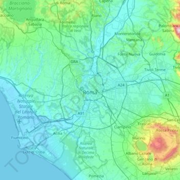
Name: Rome topographic map, elevation, terrain.
Location: Rome, Roma Capitale, Lazio, Italy (41.65564 12.23447 42.14103 12.85576)
Average elevation: 404 ft
Minimum elevation: -10 ft
Maximum elevation: 4,081 ft
Other topographic maps
Click on a map to view its topography, its elevation and its terrain.
Rome
Italy > Lazio > Roma Capitale
Although the city centre is about 24 km (15 mi) inland from the Tyrrhenian Sea, the city territory extends to the shore, where the south-western district of Ostia is located. The altitude of the central part of Rome ranges from 13 m (43 ft) above sea level (at the base of the Pantheon) to 139 m (456 ft) above…
Average elevation: 256 ft
Villa d'Este
Italy > Lazio > Roma Capitale > Tivoli
Tivoli had been a popular summer residence since ancient Roman times due to its altitude, cooler temperatures and its proximity to the Villa Hadriana, the summer residence of the Emperor Hadrian I. The position of Governor of Tivoli came with an official residence located in a former convent of the Benedictine…
Average elevation: 666 ft
Palatine Hill
Italy > Lazio > Roma Capitale > Rome
In 2007 the legendary Lupercal cave was claimed to have been found beneath the remains of the Domus Livia (House of Livia) on the Palatine. Archaeologists came across the 16-metre-deep cavity while restoring the decaying palace, with a richly decorated vault encrusted with mosaics and seashells. The Lupercal…
Average elevation: 131 ft
Area di sosta turistica Info Point Appia Antica X-XI miglio
Italy > Lazio > Roma Capitale > Marino > Poggio delle Mole
Average elevation: 499 ft
Colle Tocciarello
Italy > Lazio > Roma Capitale > Valmontone > Villaggio Rinascita
Average elevation: 912 ft
Monte Gennaro
Italy > Lazio > Roma Capitale > San Polo dei Cavalieri
Monte Gennaro is a peak in the Monti Lucretili, in Lazio, central Italy. It has an elevation of 1,271 metres (4,170 ft) and is the highest peak visible from Rome looking eastwards. It is located in the province of Rome, in the communal territories of Palombara Sabina and San Polo dei Cavalieri.
Average elevation: 3,051 ft