
Pistoia topographic map
Interactive map
Click on the map to display elevation.
About this map
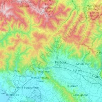
Name: Pistoia topographic map, elevation, terrain.
Location: Pistoia, Tuscany, Italy (43.78810 10.62092 44.16018 11.07148)
Average elevation: 1,739 ft
Minimum elevation: 13 ft
Maximum elevation: 6,339 ft
Other topographic maps
Click on a map to view its topography, its elevation and its terrain.
Principina Terra
Italy > Tuscany > Grosseto > Grosseto
Principina Terra, Grosseto, Tuscany, 58100, Italy
Average elevation: 10 ft
Monte Citerna
Italy > Tuscany > Metropolitan City of Florence > Barberino di Mugello
Monte Citerna, Barberino di Mugello, Metropolitan City of Florence, Tuscany, Italy
Average elevation: 2,405 ft
Le Strade
Italy > Tuscany > Monteverdi Marittimo
Le Strade, Monteverdi Marittimo, Pisa, Tuscany, Italy
Average elevation: 758 ft
Gaiole in Chianti
Italy > Tuscany > Gaiole in Chianti
Gaiole in Chianti, SI, Tuscany, 53013, Italy
Average elevation: 1,421 ft
Pontassieve
Italy > Tuscany > Pontassieve
Pontassieve, Metropolitan City of Florence, Tuscany, Italy
Average elevation: 1,194 ft
Castel del Piano
Italy > Tuscany > Castel del Piano
Castel del Piano, Unione dei Comuni Montani Amiata Grossetana, GR, Tuscany, 58033, Italy
Average elevation: 1,841 ft