
Cambridge topographic map
Click on the map to display elevation.
Cambridge
The city, like most of the UK, has a maritime climate highly influenced by the Gulf Stream. Located in the driest region of Britain, Cambridge's rainfall averages around 570 mm (22.44 in) per year, around half the national average, The driest recent year was in 2011 with 380.4 mm (14.98 in) of rain at the Botanic Garden and 347.2 mm (13.67 in) at the NIAB site. This is just below the semi-arid precipitation threshold for the area, which is 350mm of annual precipitation. Conversely, 2012 was the wettest year on record, with 812.7 mm (32.00 in) reported. Snowfall accumulations are usually small, in part because of Cambridge's low elevation, and low precipitation tendency during transitional snow events.
About this map
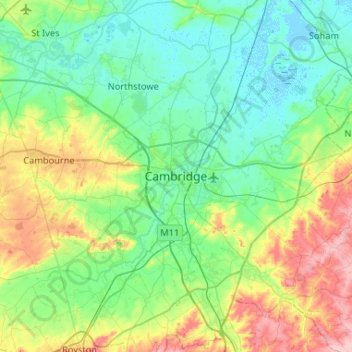
Name: Cambridge topographic map, elevation, terrain.
Average elevation: 108 ft
Minimum elevation: -13 ft
Maximum elevation: 427 ft
Other topographic maps
Click on a map to view its topography, its elevation and its terrain.
Cambridge
United Kingdom > England > Cambridgeshire
The city, like most of the UK, has a maritime climate highly influenced by the Gulf Stream. Located in the driest region of Britain, Cambridge's rainfall averages around 570 mm (22.44 in) per year, around half the national average, The driest recent year was in 2011 with 380.4 mm (14.98 in) of rain at the…
Average elevation: 59 ft
Shingay cum Wendy
United Kingdom > England > Cambridgeshire > South Cambridgeshire > Wendy
Average elevation: 92 ft
River Great Ouse or Ely Ouse
United Kingdom > England > Cambridgeshire > East Cambridgeshire > Soham > Stuntney
Average elevation: 13 ft
Brampton
United Kingdom > England > Cambridgeshire > Huntingdonshire > Brampton
Average elevation: 72 ft
Barway
United Kingdom > England > Cambridgeshire > East Cambridgeshire > Soham
Average elevation: 7 ft
Ely
United Kingdom > England > Cambridgeshire
Ely is built on a 23-square-mile (60 km2) Kimmeridge Clay island which, at 85 feet (26 m), is the highest land in the Fens. It was due to this topography that Ely was not waterlogged like the surrounding Fenland, and was an island separated from the mainland. Major rivers including the Witham, Welland, Nene…
Average elevation: 13 ft
West Wratting
United Kingdom > England > Cambridgeshire > South Cambridgeshire
Average elevation: 302 ft
Westley Waterless
United Kingdom > England > Cambridgeshire > East Cambridgeshire
Average elevation: 302 ft
Hinchingbrooke Country Park
United Kingdom > England > Cambridgeshire > Huntingdonshire > Huntingdon > Brampton
Average elevation: 52 ft
Kimbolton
United Kingdom > England > Cambridgeshire > Huntingdonshire > Kimbolton
Average elevation: 177 ft
Great Abington
United Kingdom > England > Cambridgeshire > South Cambridgeshire
Average elevation: 180 ft
Great Shelford
United Kingdom > England > Cambridgeshire > South Cambridgeshire
Average elevation: 72 ft
Bluntisham
United Kingdom > England > Cambridgeshire > Huntingdonshire > Bluntisham
Average elevation: 39 ft
Stretham
United Kingdom > England > Cambridgeshire > East Cambridgeshire > Stretham
Average elevation: 13 ft
Grafham
United Kingdom > England > Cambridgeshire > Huntingdonshire > Grafham
Average elevation: 148 ft
West Wickham
United Kingdom > England > Cambridgeshire > South Cambridgeshire
Average elevation: 338 ft
Kings Ripton
United Kingdom > England > Cambridgeshire > Huntingdonshire > Kings Ripton
Average elevation: 112 ft
Little Thetford
United Kingdom > England > Cambridgeshire > East Cambridgeshire
Average elevation: 16 ft
Dry Drayton
United Kingdom > England > Cambridgeshire > South Cambridgeshire
Average elevation: 138 ft
Papworth Everard
United Kingdom > England > Cambridgeshire > South Cambridgeshire
Average elevation: 167 ft