
Make a donation
Gear up for your next adventure:
As an Amazon Associate, this site earns from qualifying purchases at no extra cost to you.
Northern Cape topographic map
Click on the map to display elevation.
Make a donation
Gear up for your next adventure:
As an Amazon Associate, this site earns from qualifying purchases at no extra cost to you.
About this map
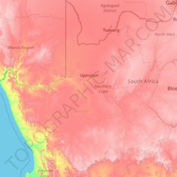
Name: Northern Cape topographic map, elevation, terrain.
Location: Northern Cape, South Africa (-32.94500 16.33352 -24.76375 25.54933)
Average elevation: 3,179 ft
Minimum elevation: 0 ft
Maximum elevation: 7,615 ft
Make a donation
Gear up for your next adventure:
As an Amazon Associate, this site earns from qualifying purchases at no extra cost to you.
Other topographic maps
Click on a map to view its topography, its elevation and its terrain.
Cape Town
South Africa > Western Cape > City of Cape Town
The Cape Peninsula is 52 km long from Mouille Point in the north to Cape Point in the south, with an area of about 470 km2, and it displays more topographical variety than other similar sized areas in southern Africa, and consequently spectacular scenery. There are diverse low-nutrient soils, large rocky…
Average elevation: 174 ft
Pretoria
South Africa > Gauteng > City of Tshwane Metropolitan Municipality
Pretoria is situated approximately 55 km (34 mi) north-northeast of Johannesburg in the northeast of South Africa, in a transitional belt between the plateau of the Highveld to the south and the lower-lying Bushveld to the north. It lies at an altitude of about 1,339 m (4,393 ft) above sea level, in a warm,…
Average elevation: 4,472 ft
Durban North
South Africa > KwaZulu-Natal > eThekwini Metropolitan Municipality
Average elevation: 135 ft
Make a donation
Gear up for your next adventure:
As an Amazon Associate, this site earns from qualifying purchases at no extra cost to you.
Mpuluzi
South Africa > Mpumalanga > Gert Sibande > Albert Luthuli Local Municipality
Average elevation: 4,783 ft
Johannesburg
South Africa > Gauteng > City of Johannesburg Metropolitan Municipality
Johannesburg is located in the eastern plateau area of South Africa known as the Highveld, at an elevation of 1,753 metres (5,751 ft). The former Central Business District is located on the southern side of the prominent ridge called the Witwatersrand (English: White Water's Ridge) and the terrain falls to the…
Average elevation: 5,299 ft
Midrand
South Africa > Gauteng > City of Johannesburg Metropolitan Municipality
Average elevation: 5,059 ft
Gqeberha
South Africa > Eastern Cape > Nelson Mandela Bay Metropolitan Municipality
Average elevation: 121 ft
Make a donation
Gear up for your next adventure:
As an Amazon Associate, this site earns from qualifying purchases at no extra cost to you.
Thohoyandou
South Africa > Limpopo > Vhembe District Municipality > Thulamela Local Municipality
Average elevation: 2,073 ft
KuGompo City
South Africa > Eastern Cape > Buffalo City Metropolitan Municipality
Average elevation: 236 ft
Matsulu
South Africa > Mpumalanga > Ehlanzeni District Municipality > Mbombela
Average elevation: 1,473 ft
Franschhoek
South Africa > Western Cape > Cape Winelands District Municipality > Stellenbosch Local Municipality
Average elevation: 1,647 ft
Make a donation
Gear up for your next adventure:
As an Amazon Associate, this site earns from qualifying purchases at no extra cost to you.
Soweto
South Africa > Gauteng > City of Johannesburg Metropolitan Municipality
Average elevation: 5,374 ft
Tshepisong
South Africa > Gauteng > City of Johannesburg Metropolitan Municipality
Average elevation: 5,505 ft
Johannesburg
South Africa > Gauteng > City of Johannesburg Metropolitan Municipality
Johannesburg is located in the eastern plateau area of South Africa known as the Highveld, at an elevation of 1,753 metres (5,751 ft). The former Central Business District is located on the southern side of the prominent ridge called the Witwatersrand (English: White Water's Ridge) and the terrain falls to the…
Average elevation: 5,299 ft
Cape Town
South Africa > Western Cape > City of Cape Town
The Cape Peninsula is 52 km long from Mouille Point in the north to Cape Point in the south, with an area of about 470 km2, and it displays more topographical variety than other similar sized areas in southern Africa, and consequently spectacular scenery. There are diverse low-nutrient soils, large rocky…
Average elevation: 174 ft
Make a donation
Gear up for your next adventure:
As an Amazon Associate, this site earns from qualifying purchases at no extra cost to you.
Malamulele
South Africa > Limpopo > Vhembe District Municipality > Thulamela Local Municipality
Average elevation: 1,778 ft
Bloemfontein
South Africa > Free State > Mangaung Metropolitan Municipality
Situated at an elevation of 1,395 m (4,577 ft) above sea level, the city is home to approximately 520,000 residents and forms part of the Mangaung Metropolitan Municipality which has a population of 747,431. It was one of the host cities for the 2010 FIFA World Cup.
Average elevation: 4,508 ft
Kempton Park
South Africa > Gauteng > City of Ekurhuleni Metropolitan Municipality
Average elevation: 5,427 ft
Giyani
South Africa > Limpopo > Mopani District Municipality > Greater Giyani Local Municipality
Average elevation: 1,578 ft
Make a donation
Gear up for your next adventure:
As an Amazon Associate, this site earns from qualifying purchases at no extra cost to you.
Umlazi
South Africa > KwaZulu-Natal > eThekwini Metropolitan Municipality
Umlazi is situated on a series of undulating hills at an average elevation of 101 metres above sea level between the uMlaza River to the north and the uMbokodweni River to the south. Another river running through Umlazi is the Siphingo River which also runs towards the south of the township.
Average elevation: 328 ft
Klipgat
South Africa > North West > Bojanala Platinum District Municipality > Madibeng Local Municipality
Average elevation: 3,802 ft
Sebokeng
South Africa > Gauteng > Sedibeng District Municipality > Emfuleni Local Municipality
Average elevation: 4,997 ft
Thembisa
South Africa > Gauteng > City of Ekurhuleni Metropolitan Municipality
Average elevation: 5,230 ft
Make a donation
Gear up for your next adventure:
As an Amazon Associate, this site earns from qualifying purchases at no extra cost to you.
Mpuluzi
South Africa > Mpumalanga > Gert Sibande > Albert Luthuli Local Municipality
Average elevation: 4,783 ft
Make a donation
Gear up for your next adventure:
As an Amazon Associate, this site earns from qualifying purchases at no extra cost to you.
Phuthaditjhaba
South Africa > Free State > Thabo Mofutsanyana District Municipality > Maluti-a-Phofung Local Municipality
Average elevation: 5,696 ft
Soweto
South Africa > Gauteng > City of Johannesburg Metropolitan Municipality
Average elevation: 5,374 ft
Sandton
South Africa > Gauteng > City of Johannesburg Metropolitan Municipality
Average elevation: 5,194 ft
Malavuwe
South Africa > Limpopo > Vhembe District Municipality > Thulamela Local Municipality
Average elevation: 1,713 ft
Make a donation
Gear up for your next adventure:
As an Amazon Associate, this site earns from qualifying purchases at no extra cost to you.
Franschhoek
South Africa > Western Cape > Cape Winelands District Municipality > Stellenbosch Local Municipality
Average elevation: 1,647 ft
Ixopo
South Africa > KwaZulu-Natal > Sisonke District Municipality > Ubuhlebezwe Local Municipality
Average elevation: 3,310 ft
Make a donation
Gear up for your next adventure:
As an Amazon Associate, this site earns from qualifying purchases at no extra cost to you.
Umdloti / eMdloti
South Africa > KwaZulu-Natal > eThekwini Metropolitan Municipality
eMdloti has a permanent population of around 3,000 people but can increase by as much as tenfold during the Christmas and Easter holiday season. Due to eMdloti's single access road (M27) from the M4/N2 interchanges, the topography, the fact that North and South Beach Roads are both cul-de-sacs and limited…
Average elevation: 125 ft
Mahikeng
South Africa > North West > Ngaka Modiri Molema District Municipality
Close to South Africa's border with Botswana, Mafikeng is 1,400 km (870 mi) northeast of Cape Town and 260 km (160 mi) west of Johannesburg. In 2001 it had a population of 49,300. In 2007 Mafikeng was reported to have a population of 250,000, of which the CBD constituted between 69,000 and 75,000. It is built…
Average elevation: 4,334 ft
Elandsrand
South Africa > North West > Bojanala Platinum District Municipality > Madibeng Local Municipality
Average elevation: 3,743 ft
Make a donation
Gear up for your next adventure:
As an Amazon Associate, this site earns from qualifying purchases at no extra cost to you.
Vaal Dam
South Africa > Free State > Fezile Dabi District Municipality > Metsimaholo Local Municipality > Deneysville
Average elevation: 4,859 ft
Mdantsane
South Africa > Eastern Cape > Buffalo City Metropolitan Municipality
Average elevation: 866 ft
Mamelodi
South Africa > Gauteng > City of Tshwane Metropolitan Municipality
Average elevation: 4,327 ft
Make a donation
Gear up for your next adventure:
As an Amazon Associate, this site earns from qualifying purchases at no extra cost to you.
Orkney
South Africa > North West > Dr Kenneth Kaunda District Municipality > Matlosana Local Municipality
Average elevation: 4,265 ft
Butterworth
South Africa > Eastern Cape > Amathole District Municipality > Mnquma Local Municipality
Average elevation: 1,965 ft
Hermanus
South Africa > Western Cape > Overberg District Municipality > Overstrand Local Municipality
Average elevation: 285 ft
Kloof
South Africa > KwaZulu-Natal > eThekwini Metropolitan Municipality
The further subdivisions and sale of portions of Richmond Farm No. 999 by the Field heirs after 1901 resulted in the birth of Kloof as a residential area: numerous plots were sold to wealthy Durban residents and businessmen, who built country house retreats close to the city, but (due to its 550 m above sea…
Average elevation: 1,575 ft
Make a donation
Gear up for your next adventure:
As an Amazon Associate, this site earns from qualifying purchases at no extra cost to you.
Randfontein
South Africa > Gauteng > West Rand District Municipality > Randfontein Local Municipality
As of 2011, Randfontein has a population of 149,286, which incorporates Mohlakeng and Toekomsrus. (In 2001, the population was 128,731.) The average elevation of the town is 1709m above sea level. The total municipal area, after recent restructuring, is 475 km2 (183 sq mi).
Average elevation: 5,581 ft
Qonce
South Africa > Eastern Cape > Buffalo City Metropolitan Municipality
Average elevation: 1,414 ft
Bizana
South Africa > Eastern Cape > Alfred Nzo District Municipality > Mbizana Local Municipality
Average elevation: 2,700 ft
Make a donation
Gear up for your next adventure:
As an Amazon Associate, this site earns from qualifying purchases at no extra cost to you.
Umdloti / eMdloti
South Africa > KwaZulu-Natal > eThekwini Metropolitan Municipality
eMdloti has a permanent population of around 3,000 people but can increase by as much as tenfold during the Christmas and Easter holiday season. Due to eMdloti's single access road (M27) from the M4/N2 interchanges, the topography, the fact that North and South Beach Roads are both cul-de-sacs and limited…
Average elevation: 125 ft
Tzaneen Dam
South Africa > Limpopo > Mopani District Municipality > Greater Tzaneen Local Municipality
Average elevation: 2,365 ft
Himeville
South Africa > KwaZulu-Natal > Sisonke District Municipality > Kwa Sani Local Municipality
Average elevation: 5,036 ft
Lusikisiki
South Africa > Eastern Cape > O.R. Tambo District Municipality > Ingquza Hill Local Municipality
Average elevation: 1,847 ft
Make a donation
Gear up for your next adventure:
As an Amazon Associate, this site earns from qualifying purchases at no extra cost to you.
Evaton
South Africa > Gauteng > Sedibeng District Municipality > Emfuleni Local Municipality
Average elevation: 4,993 ft
Johannesburg
South Africa > Gauteng > City of Johannesburg Metropolitan Municipality
Johannesburg is located in the eastern plateau area of South Africa known as the Highveld, at an elevation of 1,753 metres (5,751 ft). The former Central Business District is located on the southern side of the prominent ridge called the Witwatersrand (English: White Water's Ridge) and the terrain falls to the…
Average elevation: 5,299 ft
Benoni
South Africa > Gauteng > City of Ekurhuleni Metropolitan Municipality
Average elevation: 5,397 ft
Make a donation
Gear up for your next adventure:
As an Amazon Associate, this site earns from qualifying purchases at no extra cost to you.
Table Mountain
South Africa > Western Cape > City of Cape Town > Cape Town
Table Mountain is at the northern end of a sandstone mountain range that forms the spine of the Cape Peninsula that terminates approximately 50 kilometres (30 mi) to the south at the Cape of Good Hope and Cape Point. Immediately to the south of Table Mountain is a rugged "plateau" at a somewhat lower elevation…
Average elevation: 1,913 ft
Roodepoort
South Africa > Gauteng > City of Johannesburg Metropolitan Municipality
Average elevation: 5,226 ft
Tzaneen
South Africa > Limpopo > Mopani District Municipality > Greater Tzaneen Local Municipality
Average elevation: 2,418 ft
Soweto
South Africa > Gauteng > City of Johannesburg Metropolitan Municipality
Average elevation: 5,374 ft
Make a donation
Gear up for your next adventure:
As an Amazon Associate, this site earns from qualifying purchases at no extra cost to you.
Stellenbosch
South Africa > Western Cape > Cape Winelands District Municipality > Stellenbosch Local Municipality
Stellenbosch is 53 km (33 mi) east of Cape Town via National Route N1. Stellenbosch is in a hilly region of the Cape Winelands, and is sheltered in a valley at an average elevation of 136 m (446 ft), flanked on the west by Papegaaiberg (Afrikaans: Parrot Mountain), which is actually a hill. To the south is…
Average elevation: 942 ft
Vryburg
South Africa > North West > Dr Ruth Segomotsi Mompati District Municipality > Naledi Local Municipality
Average elevation: 3,953 ft
Pongola
South Africa > KwaZulu-Natal > Zululand District Municipality > uPhongolo Local Municipality
Average elevation: 955 ft
Centurion
South Africa > Gauteng > City of Tshwane Metropolitan Municipality
Average elevation: 4,760 ft
Make a donation
Gear up for your next adventure:
As an Amazon Associate, this site earns from qualifying purchases at no extra cost to you.
Springs
South Africa > Gauteng > City of Ekurhuleni Metropolitan Municipality
Average elevation: 5,269 ft
Brits
South Africa > North West > Bojanala Platinum District Municipality > Madibeng Local Municipality
Average elevation: 3,675 ft
Mutale
South Africa > Limpopo > Vhembe District Municipality > Thulamela Local Municipality
Average elevation: 3,333 ft
Windsorton
South Africa > Northern Cape > Frances Baard District Municipality > Dikgatlong Local Municipality
Average elevation: 3,694 ft
Make a donation
Gear up for your next adventure:
As an Amazon Associate, this site earns from qualifying purchases at no extra cost to you.
Letlhabile
South Africa > North West > Bojanala Platinum District Municipality > Moses Kotane Local Municipality
Average elevation: 3,727 ft
Carletonville
South Africa > Gauteng > West Rand District Municipality > Merafong City Local Municipality
Average elevation: 5,049 ft
Umbumbulu
South Africa > KwaZulu-Natal > eThekwini Metropolitan Municipality
Average elevation: 1,663 ft
Tarkastad
South Africa > Eastern Cape > Chris Hani District Municipality > Tsolwana Local Municipality
Scientists have stated that Tarkastad has one of the healthiest climates in the world. Winters are cold with frequent snowfalls on high lying mountain tops, while summers are hot and dry. Tarkastad which is situated at an elevation of 1,304 metres normally receives about 335mm of rain per year, with most…
Average elevation: 4,419 ft
Make a donation
Gear up for your next adventure:
As an Amazon Associate, this site earns from qualifying purchases at no extra cost to you.
Thokoza Park
South Africa > Gauteng > City of Johannesburg Metropolitan Municipality > Soweto
Average elevation: 5,262 ft
Rustenburg
South Africa > North West > Bojanala Platinum District Municipality
Rustenburg has a humid subtropical climate (Köppen Cwa), with a relatively high degree of diurnal temperature variation due to the high elevation. It has very warm summers (from December to February) and mild winters (from June to August). Due to the altitude, summers are not quite as hot as one might expect.…
Average elevation: 3,993 ft
Richards Bay
South Africa > KwaZulu-Natal > King Cetswayo District Municipality
Average elevation: 102 ft
Make a donation
Gear up for your next adventure:
As an Amazon Associate, this site earns from qualifying purchases at no extra cost to you.
Lenasia
South Africa > Gauteng > City of Johannesburg Metropolitan Municipality
Average elevation: 5,217 ft
Saldanha
South Africa > Western Cape > West Coast District Municipality > Saldanha Bay Local Municipality
Average elevation: 89 ft
Port Shepstone
South Africa > KwaZulu-Natal > Ugu District Municipality > Hibiscus Coast Local Municipality
Port Shepstone's topography is characterised by a rugged/hilly terrain with the Central Business District (CBD) lying on a large hill overlooking the Indian Ocean. Port Shepstone proper (excluding its extensions) is bordered by the uMzimkhulu River to the north and the N2 freeway to the east and is also…
Average elevation: 108 ft
White River
South Africa > Mpumalanga > Ehlanzeni District Municipality > Mbombela
White River is located in the low altitude subtropical Lowveld climatic zone. Savannah and woodland scattered with granite outcrops form the indigenous habitat. Compared to other parts of South Africa, the climate is mild with good rainfall. Nevertheless, like the rest of South Africa, White River and its…
Average elevation: 2,959 ft
Make a donation
Gear up for your next adventure:
As an Amazon Associate, this site earns from qualifying purchases at no extra cost to you.
Hillcrest
South Africa > KwaZulu-Natal > eThekwini Metropolitan Municipality
Hillcrest is situated in the Upper Highway Area of Durban, approximately 32 kilometres (20 mi) north-west of the city and is bordered by Gillitts and Everton to the east, Waterfall to the north-east and Botha's Hill and Assagay to the north-west. It lies at an altitude of approximately 680 m (2231 ft) above…
Average elevation: 2,051 ft
Vanderbijlpark
South Africa > Gauteng > Sedibeng District Municipality > Emfuleni Local Municipality
Vanderbijlpark is situated on the highveld of South Africa, at an altitude of 1,500 meters on the banks of the Vaal River. Summers in the city are warm to hot with an average high between 31 and 35°C, and an average low between 15 and 22°C. Winters in the city are cool to warm with an average high of between…
Average elevation: 4,836 ft
Randburg
South Africa > Gauteng > City of Johannesburg Metropolitan Municipality
Average elevation: 5,141 ft
Barberton
South Africa > Mpumalanga > Ehlanzeni District Municipality > Umjindi Local Municipality
Average elevation: 3,009 ft
Make a donation
Gear up for your next adventure:
As an Amazon Associate, this site earns from qualifying purchases at no extra cost to you.
Parys
South Africa > Free State > Fezile Dabi District Municipality > Ngwathe Local Municipality
Average elevation: 4,619 ft
Cradock
South Africa > Eastern Cape > Chris Hani District Municipality > Inxuba Yethemba Local Municipality
Average elevation: 3,084 ft
Port Alfred
South Africa > Eastern Cape > Sarah Baartman District Municipality > Ndlambe Local Municipality
Average elevation: 108 ft
Make a donation
Gear up for your next adventure:
As an Amazon Associate, this site earns from qualifying purchases at no extra cost to you.
Bethlehem
South Africa > Free State > Thabo Mofutsanyana District Municipality > Dihlabeng Local Municipality
The city lies at an altitude of 1,700 metres (5,600 ft) and this contributes to its cool climate with frosty winters and mild summers. The average annual temperature is around 14 °C (57 °F).
Average elevation: 5,495 ft
Piet Retief
South Africa > Mpumalanga > Gert Sibande > Mkhondo Local Municipality
Average elevation: 4,186 ft
Mossel Bay
South Africa > Western Cape > George
To the east, the land slopes upwards towards the wave-cut platform (average elevation 245 metres) that characterises the more lush all-year-round rainfall area of the Garden Route. Here the land is mostly covered by grass and farmlands. The deep sandy soils of the western portion of the municipal area also…
Average elevation: 52 ft
Empangeni
South Africa > KwaZulu-Natal > King Cetswayo District Municipality > uMhlathuze Local Municipality
Average elevation: 292 ft
Make a donation
Gear up for your next adventure:
As an Amazon Associate, this site earns from qualifying purchases at no extra cost to you.
Umgeni River
South Africa > KwaZulu-Natal > eThekwini Metropolitan Municipality > Queensburgh
Average elevation: 430 ft
Rosebank
South Africa > Gauteng > City of Johannesburg Metropolitan Municipality
Average elevation: 5,374 ft
Make a donation
Gear up for your next adventure:
As an Amazon Associate, this site earns from qualifying purchases at no extra cost to you.