
Make a donation
Gear up for your next adventure:
As an Amazon Associate, this site earns from qualifying purchases at no extra cost to you.
Los Cristianos topographic map
Click on the map to display elevation.
Make a donation
Gear up for your next adventure:
As an Amazon Associate, this site earns from qualifying purchases at no extra cost to you.
About this map
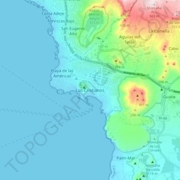
Name: Los Cristianos topographic map, elevation, terrain.
Average elevation: 279 ft
Minimum elevation: -7 ft
Maximum elevation: 1,798 ft
Make a donation
Gear up for your next adventure:
As an Amazon Associate, this site earns from qualifying purchases at no extra cost to you.
Other topographic maps
Click on a map to view its topography, its elevation and its terrain.
Peníscola / Peñíscola
Spain > Valencian Community > Castelló / Castellón > Peníscola / Peñíscola
Average elevation: 167 ft
Lugo
The town lies on a hill surrounded by the rivers Miño, Rato and Chanca. The difference in altitude between the city centre and the river banks is considerable: the former being at an altitude of 465 meters above sea level, whilst the Miño River Walk is at an altitude of only 364 metres (1,194 feet). The…
Average elevation: 1,604 ft
Make a donation
Gear up for your next adventure:
As an Amazon Associate, this site earns from qualifying purchases at no extra cost to you.
Make a donation
Gear up for your next adventure:
As an Amazon Associate, this site earns from qualifying purchases at no extra cost to you.
Huesca
Spain > Aragon > Hoya de Huesca / Plana de Uesca
Huesca lies on a plateau in the northern region of Aragón, with an elevation of 488 m (1,601.05 ft) above sea level. Close to the city lie the Sierra de Guara mountains, which reach 2,077 m. The geographical coordinates of the city are: 42° 08´ N, 0° 24´ W.
Average elevation: 1,732 ft
Jaca
Jaca has a submediterranean climate (Köppen: Cfb) bordering a submediterranean climate (Köppen: Cfa) with strong continental influences caused by the city's high altitude of 820 metres (2,690 ft). Winters are cool and summers are warm, with hot daytime temperatures but relatively cool nights. There isn't any…
Average elevation: 4,012 ft
Make a donation
Gear up for your next adventure:
As an Amazon Associate, this site earns from qualifying purchases at no extra cost to you.
Aras de los Olmos
Spain > Valencian Community > La Serranía
The climate: due to its altitude, this land has cold winters and hot summers, although with mild nights. The snow can sometimes be seen, forming beautiful landscapes.
Average elevation: 3,173 ft
Make a donation
Gear up for your next adventure:
As an Amazon Associate, this site earns from qualifying purchases at no extra cost to you.
Labastida/Bastida
Spain > Autonomous Community of the Basque Country > Arabako Errioxa/Rioja Alavesa
The town is at 529m altitude, and is positioned between the River Ebro and the Sierra de Toloño mountain range.
Average elevation: 2,005 ft
Sabadell
Spain > Catalonia > Vallès Occidental
The city covers an area of 37.79 km2 (14.59 sq mi) and its population density is 5,337.57/km2 (13,824.2/sq mi) as of 2007. The altitude is 200 metres (660 ft).
Average elevation: 600 ft
Make a donation
Gear up for your next adventure:
As an Amazon Associate, this site earns from qualifying purchases at no extra cost to you.
Make a donation
Gear up for your next adventure:
As an Amazon Associate, this site earns from qualifying purchases at no extra cost to you.
Sierra Nevada
Spain > Andalusia > Comarca de Guadix
Parts of the range have been included in the Sierra Nevada National Park. The range has also been declared a biosphere reserve. The Sierra Nevada Observatory, the Calar Alto Observatory, and the IRAM 30m telescope are located on the northern slopes at an elevation of 2,800 metres (9,200 ft).
Average elevation: 4,298 ft
Estepona
Spain > Andalusia > Costa del Sol Occidental
Estepona (Spanish pronunciation: [esteˈpona]) is a town and municipality in the comarca of the Costa del Sol, southern Spain. It is located in the province of Málaga, part of the autonomous community of Andalusia. Its district covers an area of 137 square kilometers in a fertile valley crossed by small…
Average elevation: 869 ft
San Vicente de Leira
Spain > Galicia > Valdeorras > Vilamartín de Valdeorras
Average elevation: 3,110 ft
Tamarite de Litera / Tamarit de Llitera
Spain > Aragon > La Litera / La Llitera
Average elevation: 951 ft
Make a donation
Gear up for your next adventure:
As an Amazon Associate, this site earns from qualifying purchases at no extra cost to you.
Guadalupe
The Guadalupe River has its origins near the town in the Sierra de las Villuercas. Its highest point, the Pico la Villuerca reaches an altitude of 1603 m.
Average elevation: 2,503 ft
Make a donation
Gear up for your next adventure:
As an Amazon Associate, this site earns from qualifying purchases at no extra cost to you.
Make a donation
Gear up for your next adventure:
As an Amazon Associate, this site earns from qualifying purchases at no extra cost to you.
Make a donation
Gear up for your next adventure:
As an Amazon Associate, this site earns from qualifying purchases at no extra cost to you.
Cervantes
Spain > Galicia > Os Ancares
These elevations are located in the nearby mountain ranges of A Trappe, Lóuzara, O Oribio, O Rañadoiro and O Piornal .
Average elevation: 3,255 ft
Make a donation
Gear up for your next adventure:
As an Amazon Associate, this site earns from qualifying purchases at no extra cost to you.
Chinchón
It has an irregular shape in plan with a simple and orderly structure in elevation. The buildings have three floors, with lintelled galleries and 234 wooden balconies called claros, supported by upright wooden pillars.
Average elevation: 2,185 ft
Make a donation
Gear up for your next adventure:
As an Amazon Associate, this site earns from qualifying purchases at no extra cost to you.
Make a donation
Gear up for your next adventure:
As an Amazon Associate, this site earns from qualifying purchases at no extra cost to you.
Corteconcepción
Spain > Andalusia > Sierra de Huelva
Corteconcepción is a town and municipality located in the province of Huelva, Spain. According to the 2005 census, it has a population of 620 inhabitants and covers a 49 km2 (19 sq mi) area( people/km²). It sits at an altitude of 572 m (1,877 ft) above sea level, and is 114 km (71 mi) from the capital.
Average elevation: 1,535 ft
Make a donation
Gear up for your next adventure:
As an Amazon Associate, this site earns from qualifying purchases at no extra cost to you.
Make a donation
Gear up for your next adventure:
As an Amazon Associate, this site earns from qualifying purchases at no extra cost to you.
Guardamar del Segura
Spain > Valencian Community > el Baix Segura / La Vega Baja del Segura
Average elevation: 30 ft
Make a donation
Gear up for your next adventure:
As an Amazon Associate, this site earns from qualifying purchases at no extra cost to you.
Make a donation
Gear up for your next adventure:
As an Amazon Associate, this site earns from qualifying purchases at no extra cost to you.
Make a donation
Gear up for your next adventure:
As an Amazon Associate, this site earns from qualifying purchases at no extra cost to you.
Make a donation
Gear up for your next adventure:
As an Amazon Associate, this site earns from qualifying purchases at no extra cost to you.
Getafe
Getafe is located in the southern zone of the autonomous community of Madrid, Spain, in southwestern Europe. It is physically located in the centre of the Iberian Peninsula, north of the Southern Submeseta (part of the Meseta Central), in the Manzanares River basin. Its elevation is 610 – 640 meters above…
Average elevation: 2,073 ft
Make a donation
Gear up for your next adventure:
As an Amazon Associate, this site earns from qualifying purchases at no extra cost to you.
Make a donation
Gear up for your next adventure:
As an Amazon Associate, this site earns from qualifying purchases at no extra cost to you.
Biescas
Spain > Aragon > Alto Gállego
The town of Biescas is located at 875 meters altitude on the banks of the Gállego river. The municipality extends along a small plain and includes the canyon to access to the Tena Valley. At 72 km north of the main city Huesca, Biescas is a communication hub between the regions of Jacetania and Sobrarbe. The…
Average elevation: 4,829 ft
Make a donation
Gear up for your next adventure:
As an Amazon Associate, this site earns from qualifying purchases at no extra cost to you.
Make a donation
Gear up for your next adventure:
As an Amazon Associate, this site earns from qualifying purchases at no extra cost to you.
Make a donation
Gear up for your next adventure:
As an Amazon Associate, this site earns from qualifying purchases at no extra cost to you.
Make a donation
Gear up for your next adventure:
As an Amazon Associate, this site earns from qualifying purchases at no extra cost to you.