
Dover topographic map
Click on the map to display elevation.
About this map
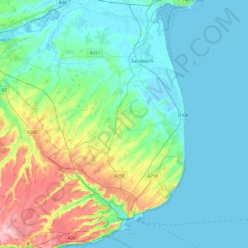
Name: Dover topographic map, elevation, terrain.
Location: Dover, Kent, England, United Kingdom (51.09719 1.14275 51.33238 1.40621)
Average elevation: 128 ft
Minimum elevation: -7 ft
Maximum elevation: 620 ft
Other topographic maps
Click on a map to view its topography, its elevation and its terrain.
Romney, Hythe and Dymchurch Railway
United Kingdom > England > Kent > Folkestone and Hythe > St. Mary in the Marsh
Average elevation: 3 ft
Painter's Forstal
United Kingdom > England > Kent > Swale > Painter's Forstal
Average elevation: 171 ft
Faversham Creek
United Kingdom > England > Kent > Borough of Swale > Faversham > Oare
Average elevation: 26 ft
Sandhurst Cross
United Kingdom > England > Kent > Tunbridge Wells > Sandhurst
Average elevation: 112 ft
Ightham Common
United Kingdom > England > Kent > Tonbridge and Malling > Ightham
Average elevation: 476 ft
Wetham Green
United Kingdom > England > Kent > Swale > Upchurch > Wetham Green
Average elevation: 26 ft
Stowting Common
United Kingdom > England > Kent > Folkestone and Hythe > Lymbridge Green > Stowting Common
Average elevation: 486 ft
Odiam wood
United Kingdom > England > Kent > Ashford > Bethersden > Wissenden
Average elevation: 112 ft
Underground reservoir
United Kingdom > England > Kent > Tunbridge Wells > Hartley > Flishinghurst
Average elevation: 338 ft
South Alkham
United Kingdom > England > Kent > Dover > Alkham > South Alkham
Average elevation: 404 ft
Faversham Creek
United Kingdom > England > Kent > Borough of Swale > Faversham > Oare
Average elevation: 36 ft
Barden Lake
United Kingdom > England > Kent > Tonbridge and Malling > Tonbridge
Average elevation: 108 ft
Whitstable and Seasalter Golf Club
United Kingdom > England > Kent > Whitstable > Seasalter
Average elevation: 46 ft
Kit's Coty
United Kingdom > England > Kent > Tonbridge and Malling > Bluebell Hill
Average elevation: 335 ft
St Margaret's Bay
United Kingdom > England > Kent > Dover > St. Margaret's at Cliffe
Average elevation: 125 ft