
兰家镇 topographic map
Interactive map
Click on the map to display elevation.
About this map
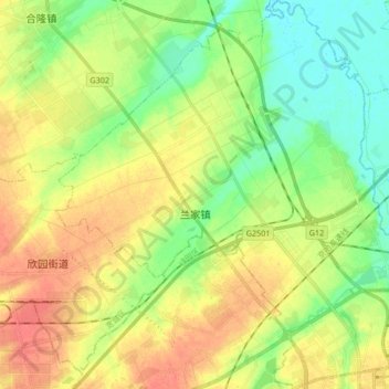
Name: 兰家镇 topographic map, elevation, terrain.
Location: 兰家镇, 宽城区, 长春市, 吉林省, 130000, 中国 (43.94287 125.18050 44.06353 125.34657)
Average elevation: 676 ft
Minimum elevation: 600 ft
Maximum elevation: 758 ft
Other topographic maps
Click on a map to view its topography, its elevation and its terrain.
南岭1932 长春水文化生态园
南岭1932 长春水文化生态园, 鸿城街道, 南关区, 长春市, 吉林省, 130000, 中国
Average elevation: 709 ft