
营城街道 topographic map
Interactive map
Click on the map to display elevation.
About this map
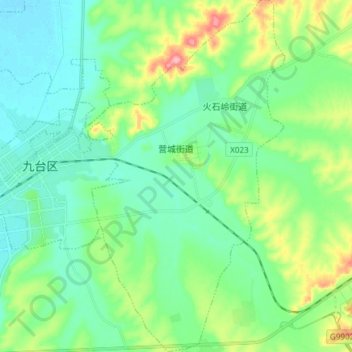
Name: 营城街道 topographic map, elevation, terrain.
Location: 营城街道, 九台区, 长春市, 吉林省, 130500, 中国 (44.09609 125.83569 44.20329 125.94445)
Average elevation: 663 ft
Minimum elevation: 558 ft
Maximum elevation: 961 ft
Other topographic maps
Click on a map to view its topography, its elevation and its terrain.
南岭1932 长春水文化生态园
南岭1932 长春水文化生态园, 鸿城街道, 南关区, 长春市, 吉林省, 130000, 中国
Average elevation: 709 ft