
东湖街道 topographic map
Interactive map
Click on the map to display elevation.
About this map
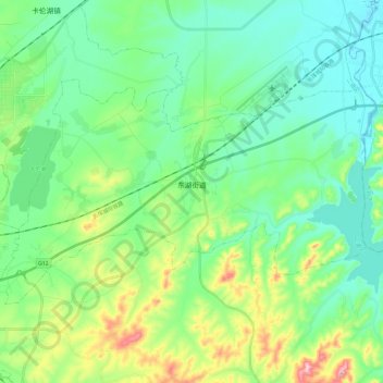
Name: 东湖街道 topographic map, elevation, terrain.
Location: 东湖街道, 二道区, 长春市, 吉林省, 130000, 中国 (43.90049 125.52012 44.00050 125.75643)
Average elevation: 751 ft
Minimum elevation: 558 ft
Maximum elevation: 1,316 ft
Other topographic maps
Click on a map to view its topography, its elevation and its terrain.
南岭1932 长春水文化生态园
南岭1932 长春水文化生态园, 鸿城街道, 南关区, 长春市, 吉林省, 130000, 中国
Average elevation: 709 ft