
长春汽车经济技术开发区 topographic map
Interactive map
Click on the map to display elevation.
About this map
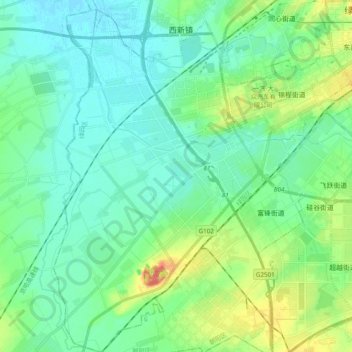
Name: 长春汽车经济技术开发区 topographic map, elevation, terrain.
Location: 长春汽车经济技术开发区, 绿园区, 长春市, 吉林省, 130000, 中国 (43.74193 125.08227 43.88182 125.26949)
Average elevation: 682 ft
Minimum elevation: 630 ft
Maximum elevation: 850 ft
Other topographic maps
Click on a map to view its topography, its elevation and its terrain.
南岭1932 长春水文化生态园
南岭1932 长春水文化生态园, 鸿城街道, 南关区, 长春市, 吉林省, 130000, 中国
Average elevation: 709 ft