
新发街道 topographic map
Interactive map
Click on the map to display elevation.
About this map
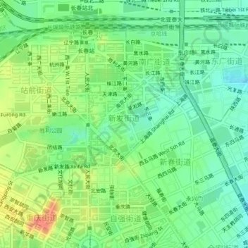
Name: 新发街道 topographic map, elevation, terrain.
Location: 新发街道, 宽城区, 长春市, 吉林省, 130000, 中国 (43.89336 125.31781 43.90248 125.33140)
Average elevation: 728 ft
Minimum elevation: 666 ft
Maximum elevation: 820 ft
Other topographic maps
Click on a map to view its topography, its elevation and its terrain.
南岭1932 长春水文化生态园
南岭1932 长春水文化生态园, 鸿城街道, 南关区, 长春市, 吉林省, 130000, 中国
Average elevation: 709 ft