Zambezi topographic map
Click on the map to display elevation.
Zambezi
The river flows to the southwest into Angola for about 240 km (150 mi), then is joined by sizeable tributaries such as the Luena and the Chifumage flowing from highlands to the north-west. It turns south and develops a floodplain, with extreme width variation between the dry and rainy seasons. It enters dense evergreen Cryptosepalum dry forest, though on its western side, Western Zambezian grasslands also occur. Where it re-enters Zambia, it is nearly 400 m (1,300 ft) wide in the rainy season and flows rapidly, with rapids ending in the Chavuma Falls, where the river flows through a rocky fissure. The river drops about 400 m (1,300 ft) in elevation from its source at 1,500 m (4,900 ft) to the Chavuma Falls at 1,100 m (3,600 ft), over a distance of about 400 km (250 mi). From this point to the Victoria Falls, the level of the basin is very uniform, dropping only by another 180 m (590 ft) across a distance of around 800 km (500 mi).
About this map
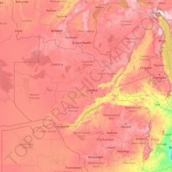
Name: Zambezi topographic map, elevation, terrain.
Location: Zambezi, Zambia (-18.62317 22.54256 -11.07455 36.46460)
Average elevation: 3,330 ft
Minimum elevation: 0 ft
Maximum elevation: 9,259 ft
Other topographic maps
Click on a map to view its topography, its elevation and its terrain.



Nakonde
This is approximately 350 kilometres (217 mi), by road, north of Mpika, the largest city in the province. The geographical coordinates of the town are: 09°19'38.0"S, 32°45'30.0"E (Latitude:-9.327222; Longitude:32.758333). The average elevation of Nakonde is about 1,306 metres (4,285 ft), above sea level.…
Average elevation: 5,292 ft



Mbala
The town is at the edge of the plateau covering most of Zambia, at an elevation of 1670 m, about 900 m higher than Lake Tanganyika, which comes within 22 km (straight-line distance). The escarpment above the lake is the end of the Albertine Rift, the western branch of the East Africa Rift, and the Mbala area…
Average elevation: 5,354 ft
Solwezi
Zambia > North-Western Province
Solwezi is located on the Chingola–Solwezi–Mwinilunga Road (T5 Road of Zambia), approximately 177 kilometres (110 mi) north-west of Chingola and approximately 275 kilometres (171 mi) south-east of Mwinilunga, in the extreme northwest of the country. The geographical coordinates of the city…
Average elevation: 4,436 ft


Chinsali
The geographical coordinates of Chinsali Town are 10°33'08.0"S, 32°04'09.0"E (Latitude:-10.552222; Longitude:32.069167). The town is nestled at an average elevation of 1,383 metres (4,537 ft) above mean sea level.
Average elevation: 4,245 ft



Kawambwa
Kawambwa is a town in the Zambian province of Luapula located on the edge of the northern Zambian plateau above the Luapula valley at an altitude of 1300 m. It was chosen as an administrative district of the same name by the British colonial authorities who preferred the climate of the plateau rather than the…
Average elevation: 4,360 ft
Lusaka
Lusaka (/luːˈsɑːkə/ loo-SAH-kə) is the capital and largest city of Zambia. It is one of the fastest-developing cities in southern Africa. Lusaka is in the southern part of the central plateau at an elevation of about 1,279 metres (4,196 ft). As of 2022, the city's population was approximately 2,204,059.…
Average elevation: 4,026 ft
Lusaka
Lusaka (/luːˈsɑːkə/; loo-SAH-kə) is the capital and largest city of Zambia. It is one of the fastest-developing cities in southern Africa. Lusaka is in the southern part of the central plateau at an elevation of about 1,279 metres (4,196 ft). As of 2019, the city's population was about 3.3 million, while…
Average elevation: 4,026 ft

Chipata
Chipata is located on the Great East Road, approximately 570 kilometres (354 mi) east of Lusaka, the capital city of Zambia. This is about 150 kilometres (93 mi) west of Lilongwe, the capital city of Malawi. The geographical coordinates of Chipata are 13°38′43.0″S, 32°38′47.0″E. The average elevation…
Average elevation: 3,717 ft


Mporokoso
Mporokoso (also spelled and pronounced 'Mpolokoso' and 'Mumpolokoso') is a town in the Northern Province of Zambia, lying at an elevation of nearly 1500 m on the flat plateau about 75 km south east of Lake Mweru Wantipa and 100 km south-west of Lake Tanganyika. It is named for Chief Mporokoso (also spelled…
Average elevation: 4,721 ft


Mwinilunga
Zambia > North-Western Province
Mwinilunga sits in the extreme north-western corner of the country, close to the international borders with Angola and the Democratic Republic of the Congo. The geographical coordinates of Mwinilunga, Zambia are:11°43'02.0"S, 24°25'44.0"E (Latitude:-11.717222; Longitude:24.428889). The average elevation of…
Average elevation: 4,413 ft
Lusaka
Lusaka (/luːˈsɑːkə/ loo-SAH-kə) is the capital and largest city of Zambia. It is one of the fastest-developing cities in southern Africa. Lusaka is in the southern part of the central plateau at an elevation of about 1,279 metres (4,196 ft). As of 2019, the city's population was about 3.3 million, while…
Average elevation: 4,026 ft

Mwinilunga
Zambia > North-Western Province
Mwinilunga sits in the extreme north-western corner of the country, close to the international borders with Angola and the Democratic Republic of the Congo. The geographical coordinates of Mwinilunga, Zambia are:11°43'02.0"S, 24°25'44.0"E (Latitude:-11.717222; Longitude:24.428889). The average elevation of…
Average elevation: 4,413 ft


Solwezi
Zambia > North-Western Province
Solwezi is located on the Chingola–Solwezi–Mwinilunga Road (T5 Road of Zambia), approximately 177 kilometres (110 mi) north-west of Chingola and approximately 275 kilometres (171 mi) south-east of Mwinilunga, in the extreme northwest of the country. The geographical coordinates of the city…
Average elevation: 4,436 ft


Chipata
Chipata is located on the Great East Road, approximately 570 kilometres (354 mi) east of Lusaka, the capital city of Zambia. This is about 150 kilometres (93 mi) west of Lilongwe, the capital city of Malawi. The geographical coordinates of Chipata are 13°38′43.0″S, 32°38′47.0″E. The average elevation…
Average elevation: 3,717 ft


Lusaka
Lusaka (/luːˈsɑːkə/; loo-SAH-kə) is the capital and largest city of Zambia. It is one of the fastest-developing cities in southern Africa. Lusaka is in the southern part of the central plateau at an elevation of about 1,279 metres (4,196 ft). As of 2019, the city's population was about 3.3 million, while…
Average elevation: 4,026 ft
Lusaka
Lusaka (/luːˈsɑːkə/ loo-SAH-kə) is the capital and largest city of Zambia. It is one of the fastest-developing cities in southern Africa. Lusaka is in the southern part of the central plateau at an elevation of about 1,279 metres (4,196 ft). As of 2019, the city's population was about 3.3 million, while…
Average elevation: 4,026 ft

Katete
Katete is a medium-sized town in the Eastern Province of Zambia, and is headquarters of Katete District. The town is at the foot of rocky hills which lie to its east, including Mpangwe Hill and Kangarema Hill, which rise to 1600 m. The hills are surrounded by cultivated fields. Katete lies on the Great East…
Average elevation: 3,507 ft

Solwezi
Zambia > North-Western Province
Solwezi is located on the Chingola–Solwezi–Mwinilunga Road (T5 Road of Zambia), approximately 177 kilometres (110 mi) north-west of Chingola and approximately 275 kilometres (171 mi) south-east of Mwinilunga, in the extreme northwest of the country. The geographical coordinates of the city…
Average elevation: 4,436 ft





Mbala
The town is at the edge of the plateau covering most of Zambia, at an elevation of 1670 m, about 900 m higher than Lake Tanganyika, which comes within 22 km (straight-line distance). The escarpment above the lake is the end of the Albertine Rift, the western branch of the East Africa Rift, and the Mbala area…
Average elevation: 5,354 ft
Lusaka
Lusaka (/luːˈsɑːkə/ loo-SAH-kə) is the capital and largest city of Zambia. It is one of the fastest-developing cities in southern Africa. Lusaka is in the southern part of the central plateau at an elevation of about 1,279 metres (4,196 ft). As of 2019, the city's population was about 3.3 million, while…
Average elevation: 4,026 ft
Mporokoso
Mporokoso (also spelled and pronounced 'Mpolokoso' and 'Mumpolokoso') is a town in the Northern Province of Zambia, lying at an elevation of nearly 1500 m on the flat plateau about 75 km south east of Lake Mweru Wantipa and 100 km south-west of Lake Tanganyika. It is named for Chief Mporokoso (also spelled…
Average elevation: 4,721 ft



Chinsali
The geographical coordinates of Chinsali Town are 10°33'08.0"S, 32°04'09.0"E (Latitude:-10.552222; Longitude:32.069167). The town is nestled at an average elevation of 1,383 metres (4,537 ft) above mean sea level.
Average elevation: 4,245 ft
Lusaka
Lusaka (/luːˈsɑːkə/; loo-SAH-kə) is the capital and largest city of Zambia. It is one of the fastest-developing cities in southern Africa. Lusaka is in the southern part of the central plateau at an elevation of about 1,279 metres (4,196 ft). As of 2019, the city's population was about 3.3 million, while…
Average elevation: 4,026 ft
Lusaka
Lusaka (/luːˈsɑːkə/ loo-SAH-kə) is the capital and largest city of Zambia. It is one of the fastest-developing cities in southern Africa. Lusaka is in the southern part of the central plateau at an elevation of about 1,279 metres (4,196 ft). As of 2019, the city's population was about 3.3 million, while…
Average elevation: 4,026 ft