
鸣音镇 topographic map
Interactive map
Click on the map to display elevation.
About this map
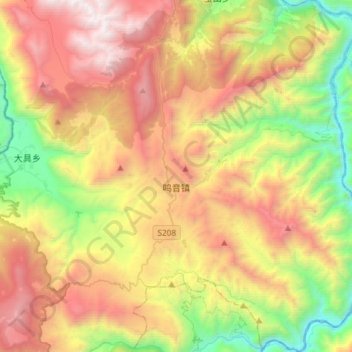
Name: 鸣音镇 topographic map, elevation, terrain.
Location: 鸣音镇, 玉龙纳西族自治县, 丽江市, 云南省, 中国 (27.15886 100.28087 27.41921 100.53915)
Average elevation: 8,852 ft
Minimum elevation: 4,554 ft
Maximum elevation: 14,157 ft
Other topographic maps
Click on a map to view its topography, its elevation and its terrain.