
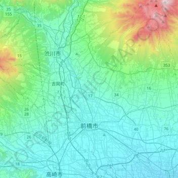
Maebashi topographic map
Interactive map
Click on the map to display elevation.
About this map
Name: Maebashi topographic map, elevation, terrain.
Location: Maebashi, Gunma Prefecture, Japan (36.31621 139.00162 36.56238 139.23014)
Average elevation: 1,115 ft
Minimum elevation: 190 ft
Maximum elevation: 5,919 ft
Maebashi is located at the foot of Mount Akagi in the northeast corner of the Kantō Plain. It is also surrounded by Mount Haruna and Mount Myōgi. Two rivers run through the city: the Tone River, Japan's second-longest, and the Hirose River. Although it is located inland more than 100 kilometers away from the coast, the elevation of the southern part of the city is only around 100 meters. The highest elevation is 1823 meters above sea level on the south side of Mt. Kurohino, a peak of Mount Akagi. Maebashi is the farthest from the sea (about 120 km) of all Japanese prefectural capitals. The surrounding cities comprise an urban zone of over 1 million people, separated by farmland to the south from the built up areas of Greater Tokyo.
Other topographic maps
Click on a map to view its topography, its elevation and its terrain.
Ozora
Ozora, Abashiri County, Okhotsk Subprefecture, Hokkaido Prefecture, Japan
Average elevation: 371 ft
Biratori
Biratori, Saru County, Hidaka Subprefecture, Hokkaido Prefecture, Japan
Average elevation: 607 ft
Toshima Island
Toshima Island, Maizuru, Kyoto Prefecture, Japan
Average elevation: 69 ft
Niseko
Niseko, Abuta County, Shiribeshi Subprefecture, Hokkaido Prefecture, Japan
Average elevation: 1,112 ft
Nichinan
Nichinan, Hino County, Tottori Prefecture, Japan
Average elevation: 1,906 ft
Noto
Noto, Houshi County, Ishikawa Prefecture, Chubu Region, Japan
Average elevation: 184 ft
Kitanakagusuku
Kitanakagusuku, Nakagami, Okinawa Prefecture, Japan
Average elevation: 194 ft
Watarase Usuichi
Watarase Usuichi, Tochigi, Tochigi Prefecture, 374-0112, Japan
Average elevation: 59 ft
Minakami
Minakami, Tone County, Gunma Prefecture, Japan
Average elevation: 3,350 ft
Saza
Saza, Kita-Matsuura County, Nagasaki Prefecture, 857-0322, Japan
Average elevation: 364 ft
Arita
Arita, Nishi-Matsuura County, Saga Prefecture, Japan
Average elevation: 604 ft
Sagara
Sagara, Kuma County, Kumamoto Prefecture, 868-0094, Japan
Average elevation: 1,385 ft
Hakone
Hakone, Ashigarashimo County, Kanagawa Prefecture, Japan
Average elevation: 2,369 ft
Nakaniikawa County
Nakaniikawa County, Toyama Prefecture, Chubu Region, Japan
Average elevation: 2,182 ft
Furuu County
Furuu County, Shiribeshi Subprefecture, Hokkaido Prefecture, Japan
Average elevation: 407 ft
Ashigarashimo County
Ashigarashimo County, Kanagawa Prefecture, Japan
Average elevation: 1,056 ft