Geolocate

Sarikei Division topographic map

Click on the map to display elevation.

About this map

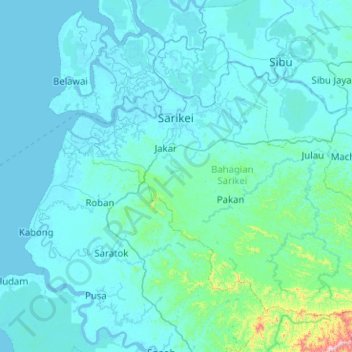
Name: Sarikei Division topographic map, elevation, terrain.

Location: Sarikei Division, Sarawak, 96100, Malaysia (1.56031 111.20291 2.36272 112.21488)

Average elevation: 174 ft

Minimum elevation: -16 ft

Maximum elevation: 4,075 ft

Other topographic maps

Click on a map to view its topography, its elevation and its terrain.

Pijiru

Malaysia > Sarawak > Bau

Average elevation: 112 ft

Kapit

Malaysia > Sarawak > Kapit

Average elevation: 574 ft

Similajau National Park

Malaysia > Sarawak > Bintulu

Average elevation: 95 ft

Kampung Telok Melano

Malaysia > Sarawak > Lundu

Average elevation: 207 ft

Pangkalan

Malaysia > Sarawak > Miri

Average elevation: 13 ft

Sibu

Malaysia > Sarawak > Sibu

Sibu is located near the Rajang delta at the confluence of Rajang and Igan rivers. Peat swamp forests and alluvial plains are particularly prevalent in the Sibu Division. Sibu is located on a deep peat soil, which has caused problems in infrastructure development because buildings and roads slowly sink into…

Average elevation: 33 ft

Balingian

Malaysia > Sarawak > Mukah

Average elevation: 16 ft

Simunjan

Malaysia > Sarawak > Simunjan

Average elevation: 10 ft

Batang Ai

Malaysia > Sarawak > Lubok Antu

Average elevation: 400 ft

Canada Hill

Malaysia > Sarawak > Miri > Miri

Average elevation: 72 ft

Gunung Tempurung

Malaysia > Sarawak > Lundu

Average elevation: 3,583 ft

Engkilili

Malaysia > Sarawak

Average elevation: 79 ft

Batu Niah

Malaysia > Sarawak

Average elevation: 141 ft

Permai Jaya

Malaysia > Sarawak > Permai Jaya

Average elevation: 33 ft

Trusan

Malaysia > Sarawak > Trusan

Average elevation: 138 ft

Happy Garden

Malaysia > Sarawak > Happy Garden

Average elevation: 102 ft

Sarikei

Malaysia > Sarawak > Sarikei

Average elevation: 46 ft

Blue Lake

Malaysia > Sarawak > Bau

Average elevation: 135 ft

Pusa

Malaysia > Sarawak > Pusa

Average elevation: 16 ft

Lawas

Malaysia > Sarawak > Lawas

Average elevation: 85 ft

Batu Bungan

Malaysia > Sarawak

Average elevation: 236 ft

Bario

Malaysia > Sarawak

Bario is a community of 13 to 16 villages located on the Kelabit Highlands in Miri Division, Sarawak, Malaysia, lying at an altitude of 1000 m (3280 ft) above sea level. It is located close to the Sarawak-Kalimantan border, 178 km to the east of Miri. It is the main settlement for the indigenous Kelabit tribe.…

Average elevation: 3,835 ft

Sibu Division

Malaysia > Sarawak > Sibu

Average elevation: 259 ft

Gear up for your next adventure:

📖Nature Tracking Books - Learn to track wildlife and terrain
📱Solar Portable Charger - Solar power bank for charging devices off‑grid
Camping Coffee Makers - Enjoy premium coffee at the summit or campsite
🗺️NatGeo Topo Maps - High-quality waterproof printed topographic maps of US Parks
🍳Camping Cook Set - Complete cookware for outdoor meals

As an Amazon Associate, this site earns from qualifying purchases at no extra cost to you.