Geolocate

Yara topographic map

Click on the map to display elevation.

About this map
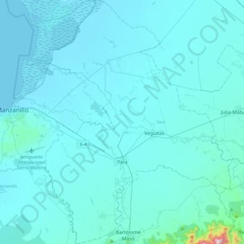
Name: Yara topographic map, elevation, terrain.

Location: Yara, Granma, 87400, Cuba (20.15554 -77.09773 20.50078 -76.78795)

Average elevation: 141 ft

Minimum elevation: 0 ft

Maximum elevation: 2,858 ft

Other topographic maps

Click on a map to view its topography, its elevation and its terrain.

Havana

Cuba

Between 1514 and 1519, the Spanish established the first settlements on the northern coast of Cuba near present-day Havana. One of them was called La Chorrera, on the current site of the Tower of La Chorrera, next to the mouth of the Almendares River. This settlement was in a better location than the first on…

Average elevation: 98 ft

Modesta

Cuba > Camagüey

Average elevation: 213 ft

Aserradero

Cuba > Guamá

Average elevation: 276 ft

Havana

Cuba > Havana > La Habana Vieja

There are low hills on which the city lies rise gently from the waters of the straits. A noteworthy elevation is the 200-foot-high (60-meter) limestone ridge that slopes up from the east and culminates in the heights of La Cabaña and El Morro, the sites of Spanish fortifications overlooking the eastern bay.…

Average elevation: 98 ft

Havana

Cuba

There are low hills on which the city lies rise gently from the waters of the straits. A noteworthy elevation is the 200-foot-high (60-meter) limestone ridge that slopes up from the east and culminates in the heights of La Cabaña and El Morro, the sites of Spanish fortifications overlooking the eastern bay.…

Average elevation: 98 ft

Guantanamo

Cuba > Guantánamo > Guantanamo

Average elevation: 482 ft

Quinta de los Molinos

Cuba > Havana

Average elevation: 66 ft

Havana

Cuba

There are low hills on which the city lies rise gently from the waters of the straits. A noteworthy elevation is the 200-foot-high (60-meter) limestone ridge that slopes up from the east and culminates in the heights of La Cabaña and El Morro, the sites of Spanish fortifications overlooking the eastern bay.…

Average elevation: 98 ft

Yugoslavia

Cuba > Matanzas > Matanzas

Average elevation: 49 ft

Nueva Gerona

Cuba > Isle of Youth

Average elevation: 43 ft

El Cobre

Cuba > Santiago de Cuba > Santiago de Cuba

Average elevation: 797 ft

Cayo Santa María

Cuba > Villa Clara

Average elevation: 3 ft

Covadonga

Cuba > Cienfuegos

Average elevation: 30 ft

Soroa

Cuba > Artemisa > Candelaria

Average elevation: 673 ft

Las Terrazas

Cuba > Artemisa > Candelaria

Average elevation: 830 ft

La Minerva

Cuba > Villa Clara > Santa Clara > Manajanabo

Average elevation: 295 ft

Xavier

Cuba > Santiago de Cuba > Contramaestre

Average elevation: 495 ft

Guanabo

Cuba > Havana > Habana del Este

Average elevation: 43 ft

Bijabo

Cuba > Sancti Spiritus > Trinidad > Meyer

Average elevation: 138 ft

Tapaste

Cuba > Mayabeque > San José de las Lajas

Average elevation: 509 ft

Toa

Cuba > Guantánamo > Baracoa

Average elevation: 545 ft

Centeno

Cuba > Sancti Spiritus > Yaguajay

Average elevation: 118 ft

Maneadero

Cuba > Matanzas > Ciénaga de Zapata

Average elevation: 7 ft

Rancho Mar

Cuba > Artemisa > Bauta > Lazo de la Vega

Average elevation: 66 ft

Turquino National Park

Cuba > Santiago de Cuba > Guamá

Average elevation: 1,624 ft

Bijabo

Cuba > Sancti Spiritus > Trinidad > Meyer

Average elevation: 138 ft

Nueva Gerona

Cuba > Isle of Youth

Average elevation: 43 ft

La Treinta

Cuba > Ciego de Avila > Bolivia

Average elevation: 49 ft

San Pablo

Cuba > Sancti Spiritus > Sancti Spiritus

Average elevation: 243 ft

Covadonga

Cuba > Cienfuegos

Average elevation: 30 ft

La Conchita

Cuba > Artemisa > San Cristóbal

Average elevation: 128 ft

Las Cuevas

Cuba > Santiago de Cuba > Guamá

Average elevation: 584 ft

Meneses

Cuba > Sancti Spiritus

Average elevation: 699 ft

Zapato

Cuba > Matanzas > Martí

Average elevation: 43 ft

Los Jagüeyes

Cuba > Guantánamo > Maisí

Average elevation: 1,211 ft

Indio Hatuey

Cuba > Matanzas > Perico

Average elevation: 75 ft

Yugoslavia

Cuba > Matanzas > Matanzas

Average elevation: 49 ft

Cayo Buba

Cuba > Matanzas > Varadero

Average elevation: 0 ft

Banao

Cuba > Sancti Spiritus > Sancti Spiritus

Average elevation: 669 ft

Caraballo

Cuba > Mayabeque > Caraballo

Average elevation: 361 ft

Clarita

Cuba > Camagüey > Vertientes

Average elevation: 187 ft

Los Jagüeyes

Cuba > Guantánamo > Maisí

Average elevation: 1,211 ft

Cangrejeras

Cuba > Artemisa

Average elevation: 89 ft

Havana

Cuba

There are low hills on which the city lies rise gently from the waters of the straits. A noteworthy elevation is the 200-foot-high (60-meter) limestone ridge that slopes up from the east and culminates in the heights of La Cabaña and El Morro, the sites of Spanish fortifications overlooking the eastern bay.…

Average elevation: 98 ft

Vega Larga

Cuba > Guantánamo > Baracoa

Average elevation: 180 ft

Cayo Largo

Cuba > Isle of Youth

Average elevation: 3 ft

San Francisco

Cuba > Cienfuegos > Cumanayagua > San Francisco

Average elevation: 148 ft

Gear up for your next adventure:

🎒Waterproof Dry Bags - Keep your electronics and maps dry inside your pack
🗺️NatGeo Topo Maps - High-quality waterproof printed topographic maps of US Parks
🪶Fire Starter Kit - Reliable fire starter for survival and camping
🪶Thermal Camp Blanket - Extra warmth for cold nights
🌎3D Topographic Globes - Raised relief globes for a tactile understanding of geography

As an Amazon Associate, this site earns from qualifying purchases at no extra cost to you.