
Havana topographic map
Click on the map to display elevation.
Havana
There are low hills on which the city lies rise gently from the waters of the straits. A noteworthy elevation is the 200-foot-high (60-meter) limestone ridge that slopes up from the east and culminates in the heights of La Cabaña and El Morro, the sites of Spanish fortifications overlooking the eastern bay. Another notable rise is the hill to the west that is occupied by the University of Havana and the Castillo del Príncipe (Havana).
About this map
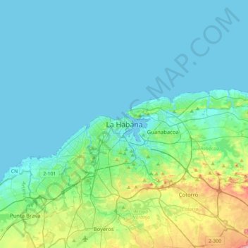
Name: Havana topographic map, elevation, terrain.
Location: Havana, Habana del Este, 10000, Cuba (22.97531 -82.51896 23.29531 -82.19896)
Average elevation: 98 ft
Minimum elevation: 0 ft
Maximum elevation: 643 ft
Other topographic maps
Click on a map to view its topography, its elevation and its terrain.
Venezuela
Cuba > Ciego de Avila > Venezuela
Shaped roughly like a triangle, the country has a 2,800 km (1,700 mi) coastline in the north, which includes numerous islands in the Caribbean and the northeast borders the northern Atlantic Ocean. Most observers describe Venezuela in terms of four fairly well defined topographical regions: the Maracaibo…
Average elevation: 62 ft
Zapata Swamp
The Zapata Swamp lies between 22°01’ and 22°40’ N latitude and between 80°33’ and 82°09’ W longitude. The swamp in total is over one million acres (4,000 km2). Topographically, the maximum height above sea level is only about 10 meters with the top depth in below-sea-level coastal zones as follows:…
Average elevation: 59 ft
Pinar del Rio
The Pinar del Río province is Cuba's westernmost province and contains one of Cuba's three main mountain ranges, the Cordillera de Guaniguanico, divided into the easterly Sierra del Rosario and the westerly Sierra de los Órganos. These form a landscape characterised by steep sided limestone hills (called…
Average elevation: 49 ft
Villa Clara
Around Santa Clara, the land rises into the Alturas de Santa Clara. The highest point in the Santa Clara region is in the Alturas, at 464 m (1,522 ft) above sea level, while the south, dominated by the Escambray Mountains, reach elevations of over 900 m (3,000 ft). Villa Clara also has numerous lakes, which…
Average elevation: 171 ft
Florida
The municipality is located northwest of its province, next to the borders with Ciego de Ávila Province. Its elevation is represented by the Urabo Mountain with a height of 132.5 m. The bordering municipalities are Baraguá, Céspedes, Esmeralda, Camagüey and Vertientes.
Average elevation: 180 ft
Villa Clara
Around Santa Clara, the land rises into the Alturas de Santa Clara. The highest point in the Santa Clara region is in the Alturas, at 464 m (1,522 ft) above sea level, while the south, dominated by the Escambray Mountains, reach elevations of over 900 m (3,000 ft). Villa Clara also has numerous lakes, which…
Average elevation: 171 ft