
Make a donation
Gear up for your next adventure:
As an Amazon Associate, this site earns from qualifying purchases at no extra cost to you.
Muli Tibetan Autonomous County topographic map
Click on the map to display elevation.
Make a donation
Gear up for your next adventure:
As an Amazon Associate, this site earns from qualifying purchases at no extra cost to you.
Muli Tibetan Autonomous County
Since 1987, Muli Monastery has been partly restored and now has about eighty young monks in residence. It is near a modern small town called Wachang, located high up on the western edge of the Litang River Valley at about 3000 metres altitude. The other monasteries are Kulu (now known as Kangwu), which has been partially rebuilt, and Waerdje (now Wa’erzhai) which is still in ruins.
Make a donation
Gear up for your next adventure:
As an Amazon Associate, this site earns from qualifying purchases at no extra cost to you.
About this map
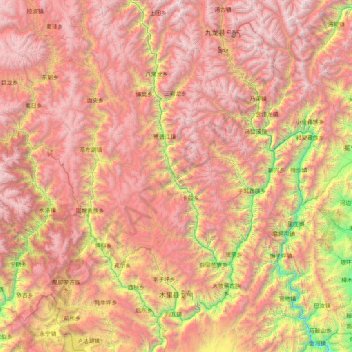
Name: Muli Tibetan Autonomous County topographic map, elevation, terrain.
Average elevation: 11,122 ft
Minimum elevation: 4,150 ft
Maximum elevation: 17,927 ft
Make a donation
Gear up for your next adventure:
As an Amazon Associate, this site earns from qualifying purchases at no extra cost to you.
Other topographic maps
Click on a map to view its topography, its elevation and its terrain.
Batang
It is warmer here than most of Tibet (because of the lower altitude) and is reported to be a friendly, easy-going place, surrounded by barley fields. The plain surrounding the town is unusually fertile and produces two harvests a year. The main products include: rice, maize, barley, wheat, peas, cabbages,…
Average elevation: 12,822 ft
Make a donation
Gear up for your next adventure:
As an Amazon Associate, this site earns from qualifying purchases at no extra cost to you.
Make a donation
Gear up for your next adventure:
As an Amazon Associate, this site earns from qualifying purchases at no extra cost to you.
Make a donation
Gear up for your next adventure:
As an Amazon Associate, this site earns from qualifying purchases at no extra cost to you.
Make a donation
Gear up for your next adventure:
As an Amazon Associate, this site earns from qualifying purchases at no extra cost to you.
Mount Gongga
China > Sichuan > Luding County
Mount Gongga (simplified Chinese: 贡嘎山; traditional Chinese: 貢嘎山; pinyin: Gònggá Shān), also known as Minya Konka (Khams Tibetan pinyin: Mi'nyâg Gong'ga Riwo) and colloquially as "The King of Sichuan Mountains", is the highest mountain in Sichuan province, China. It has an elevation of 7,556 m…
Average elevation: 21,342 ft
Garzê Tibetan Autonomous Prefecture
China > Sichuan > Garzê Tibetan Autonomous Prefecture
Average elevation: 12,792 ft
Garze
China > Sichuan > Garzê County
Due to its elevation, Garzê County has a monsoon-influenced humid continental climate (Köppen Dwb) and subarctic climate, with cold but very dry winters, and warm summers with frequent rain. The monthly 24-hour average temperature ranges from −3.9 °C (25.0 °F) in January to 14.2 °C (57.6 °F) in July,…
Average elevation: 13,688 ft
Make a donation
Gear up for your next adventure:
As an Amazon Associate, this site earns from qualifying purchases at no extra cost to you.
Make a donation
Gear up for your next adventure:
As an Amazon Associate, this site earns from qualifying purchases at no extra cost to you.