
Make a donation
Gear up for your next adventure:
As an Amazon Associate, this site earns from qualifying purchases at no extra cost to you.
Bahamas topographic map
Click on the map to display elevation.
Gear up for your next adventure:
As an Amazon Associate, this site earns from qualifying purchases at no extra cost to you.
Bahamas
The topography of the Bahamas is primarily flat and low-lying, characterized by limestone formations, sandy beaches, and a unique geological feature known as the Great Bahama Bank. Most of the islands have elevations that seldom rise above 30 feet (9 meters) above sea level, with the terrain generally ranging from sea level to slightly elevated plateaus. The largest island, Andros, features extensive wetlands and pine forests on its plateau, contributing to significant biodiversity. The region is also renowned for its blue holes—underwater sinkholes formed from collapsed cave systems—which not only offer stunning natural beauty but also serve as critical habitats for various marine species. The surrounding waters are shallow, creating rich ecosystems that include coral reefs, seagrass beds, and mangrove forests, vital for marine life and as buffers against storm surges. Overall, the Bahamas' terrain plays a crucial role in supporting its diverse ecosystems while also being shaped by climatic influences and geological history.
Make a donation
Gear up for your next adventure:
As an Amazon Associate, this site earns from qualifying purchases at no extra cost to you.
About this map
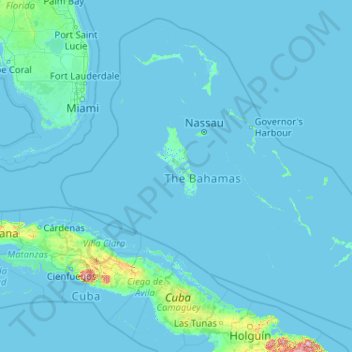
Name: Bahamas topographic map, elevation, terrain.
Location: Bahamas (20.70598 -80.70019 27.47346 -72.44775)
Average elevation: 30 ft
Minimum elevation: -13 ft
Maximum elevation: 3,645 ft
Make a donation
Gear up for your next adventure:
As an Amazon Associate, this site earns from qualifying purchases at no extra cost to you.
Other topographic maps
Click on a map to view its topography, its elevation and its terrain.
Make a donation
Gear up for your next adventure:
As an Amazon Associate, this site earns from qualifying purchases at no extra cost to you.
Make a donation
Gear up for your next adventure:
As an Amazon Associate, this site earns from qualifying purchases at no extra cost to you.
Make a donation
Gear up for your next adventure:
As an Amazon Associate, this site earns from qualifying purchases at no extra cost to you.
Make a donation
Gear up for your next adventure:
As an Amazon Associate, this site earns from qualifying purchases at no extra cost to you.
Make a donation
Gear up for your next adventure:
As an Amazon Associate, this site earns from qualifying purchases at no extra cost to you.
Make a donation
Gear up for your next adventure:
As an Amazon Associate, this site earns from qualifying purchases at no extra cost to you.
Make a donation
Gear up for your next adventure:
As an Amazon Associate, this site earns from qualifying purchases at no extra cost to you.
Make a donation
Gear up for your next adventure:
As an Amazon Associate, this site earns from qualifying purchases at no extra cost to you.