
Ruyigi topographic map
Click on the map to display elevation.
About this map
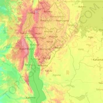
Name: Ruyigi topographic map, elevation, terrain.
Location: Ruyigi, Burundi (-6.11726 27.64804 -0.91726 32.84804)
Average elevation: 4,121 ft
Minimum elevation: 1,883 ft
Maximum elevation: 13,780 ft
Other topographic maps
Click on a map to view its topography, its elevation and its terrain.
Ruvubu
The Ruvubu River originates on the Congo-Nile ridge at Ngoga, at an altitude of 2,300 metres (7,500 ft). It flows from northwest to southeast to Mugera, and from there, takes a northeast direction. It flows for 285 kilometres (177 mi) through Burundi, and drains most of Burundi’s part of the Nile watershed.…
Average elevation: 4,944 ft
Gitega
Burundi is diversifying from the main economic activities of agriculture and livestock farming. One such micro project is in the fisheries sector in Gitega. In 1999, the Dushirehamwe fish farm association was established in the province with 23 men and women. In 2002, they received a grant from Africare. After…
Average elevation: 5,686 ft
Kirundo
88% of the province is in the Bugesera natural region. This is a vast batholithic depression carved out of granite rocks. The central plateau has an altitude of 1,500 to 2,000 metres (4,900 to 6,600 ft), and the north is lower, with an average altitude of 1,300 metres (4,300 ft). The Bugesera region is part of…
Average elevation: 4,813 ft