
Cankuzo topographic map
Click on the map to display elevation.
About this map
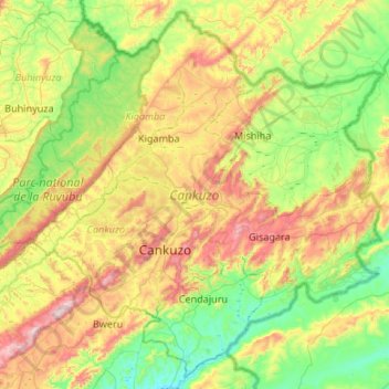
Name: Cankuzo topographic map, elevation, terrain.
Location: Cankuzo, Burundi (-3.39595 30.31471 -2.89404 30.84985)
Average elevation: 4,918 ft
Minimum elevation: 3,976 ft
Maximum elevation: 6,745 ft
Other topographic maps
Click on a map to view its topography, its elevation and its terrain.
Bujumbura
Bujumbura has a tropical savanna climate (Köppen: Aw) bordering on hot semi-arid (BSh). There are distinct wet and dry seasons; the wet season being from October to April. Being close to the equator, average temperatures in the city vary little over the year, though they are affected by its altitude. The high…
Average elevation: 3,629 ft
Itaba
The climate is tropical, and is moderated by altitude. Under normal conditions, the dry season is from three to four months from June to September. In general, the climate is mild with regular and abundant rainfall. The annual average temperature is 19.7 °C (average maximum 25.5 °C, minimum average 13.8…
Average elevation: 5,692 ft
Bujumbura
Bujumbura features a tropical savanna climate (Köppen: Aw) bordering on a hot semi-arid climate (BSh). There are distinct wet and dry seasons. Its wet season is from October to April, while the dry season covers the remaining five months. Despite being located close to the equator, Bujumbura is not as hot as…
Average elevation: 3,629 ft
Bujumbura
Bujumbura has a tropical savanna climate (Köppen: Aw) bordering on hot semi-arid (BSh). There are distinct wet and dry seasons; the wet season being from October to April. Being close to the equator, average temperatures in the city vary little over the year, though they are affected by its altitude. The high…
Average elevation: 3,629 ft