
Gitega topographic map
Click on the map to display elevation.
Gitega
Burundi is diversifying from the main economic activities of agriculture and livestock farming. One such micro project is in the fisheries sector in Gitega. In 1999, the Dushirehamwe fish farm association was established in the province with 23 men and women. In 2002, they received a grant from Africare. After the success of the first fish farm under the grant, the association successfully launched a second project with its own funds in 2003. Africare has also supported measures to strengthen civil society organizations. While the principal hospital in the province is Gitega Hospital in Gitega City, the only state-run rehabilitation center for landmine victims is located in the province. The principal airport is Gitega Airport (IATA: GID, ICAO: HBBE) which has an elevation of 1,750 metres (5,740 ft) with a runway of 1,000 metres (3,300 ft).
About this map
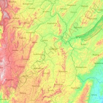
Name: Gitega topographic map, elevation, terrain.
Location: Gitega, Burundi (-3.84476 29.71786 -3.05661 30.10402)
Average elevation: 5,686 ft
Minimum elevation: 3,780 ft
Maximum elevation: 8,750 ft
Other topographic maps
Click on a map to view its topography, its elevation and its terrain.
Bujumbura
Bujumbura has a tropical savanna climate (Köppen: Aw) bordering on hot semi-arid (BSh). There are distinct wet and dry seasons; the wet season being from October to April. Being close to the equator, average temperatures in the city vary little over the year, though they are affected by its altitude. The high…
Average elevation: 3,629 ft
Itaba
The climate is tropical, and is moderated by altitude. Under normal conditions, the dry season is from three to four months from June to September. In general, the climate is mild with regular and abundant rainfall. The annual average temperature is 19.7 °C (average maximum 25.5 °C, minimum average 13.8…
Average elevation: 5,692 ft
Bujumbura
Bujumbura features a tropical savanna climate (Köppen: Aw) bordering on a hot semi-arid climate (BSh). There are distinct wet and dry seasons. Its wet season is from October to April, while the dry season covers the remaining five months. Despite being located close to the equator, Bujumbura is not as hot as…
Average elevation: 3,629 ft
Bujumbura
Bujumbura has a tropical savanna climate (Köppen: Aw) bordering on hot semi-arid (BSh). There are distinct wet and dry seasons; the wet season being from October to April. Being close to the equator, average temperatures in the city vary little over the year, though they are affected by its altitude. The high…
Average elevation: 3,629 ft