
Kirundo topographic map
Click on the map to display elevation.
Kirundo
88% of the province is in the Bugesera natural region. This is a vast batholithic depression carved out of granite rocks. The central plateau has an altitude of 1,500 to 2,000 metres (4,900 to 6,600 ft), and the north is lower, with an average altitude of 1,300 metres (4,300 ft). The Bugesera region is part of the Kirundo district, a depression in the inter-lacustrine zone of East Africa that extends across northeastern Burundi and southeastern Rwanda. It is bounded to the west by the Kanyaru River valley. To the north, east and south it is bounded by dissected plateaus that rise above it. The depression contains large valleys holding Holocene sediments, swamps and shallow lakes.
About this map
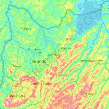
Name: Kirundo topographic map, elevation, terrain.
Location: Kirundo, Burundi (-2.78486 29.92036 -2.32738 30.41747)
Average elevation: 4,813 ft
Minimum elevation: 4,334 ft
Maximum elevation: 6,273 ft
Other topographic maps
Click on a map to view its topography, its elevation and its terrain.
Bujumbura
Bujumbura has a tropical savanna climate (Köppen: Aw) bordering on hot semi-arid (BSh). There are distinct wet and dry seasons; the wet season being from October to April. Being close to the equator, average temperatures in the city vary little over the year, though they are affected by its altitude. The high…
Average elevation: 3,629 ft
Itaba
The climate is tropical, and is moderated by altitude. Under normal conditions, the dry season is from three to four months from June to September. In general, the climate is mild with regular and abundant rainfall. The annual average temperature is 19.7 °C (average maximum 25.5 °C, minimum average 13.8…
Average elevation: 5,692 ft
Bujumbura
Bujumbura features a tropical savanna climate (Köppen: Aw) bordering on a hot semi-arid climate (BSh). There are distinct wet and dry seasons. Its wet season is from October to April, while the dry season covers the remaining five months. Despite being located close to the equator, Bujumbura is not as hot as…
Average elevation: 3,629 ft
Bujumbura
Bujumbura has a tropical savanna climate (Köppen: Aw) bordering on hot semi-arid (BSh). There are distinct wet and dry seasons; the wet season being from October to April. Being close to the equator, average temperatures in the city vary little over the year, though they are affected by its altitude. The high…
Average elevation: 3,629 ft