
Karuzi topographic map
Interactive map
Click on the map to display elevation.
About this map
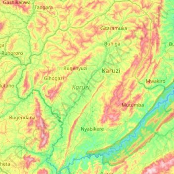
Name: Karuzi topographic map, elevation, terrain.
Location: Karuzi, Burundi (-3.39297 29.89708 -2.90297 30.35020)
Average elevation: 5,236 ft
Minimum elevation: 4,455 ft
Maximum elevation: 6,719 ft
Other topographic maps
Click on a map to view its topography, its elevation and its terrain.
Buterere
Burundi > Bujumbura Mairie > Buterere
Buterere, Bujumbura Mairie, 331, Burundi
Average elevation: 2,589 ft